More From Contributor

£9.99
Camino Francés, the main route of the Way of St. James across northern Spain from Roncesvalles in the Pyrenees to Santiago de Compostela on a double-sided, waterproof & tear-resistant map from IGN France with cartography & tourist information identical to coverage of this route by Kompass map No. 133. The IGN map differs from Kompass map No. 133 by presenting the start of Camino Francés at Roncesvalles rather than from Col de Somport; from Puente la Reina just south of Pamplona, both maps have identical 36 x 8cm panels, with the IGN coverage finishing just west of Santiago, while the Kompass map covers the route onwards to Cape Finisterre. The panels present the route with the surrounding network of local roads & country tracks as well as railway connections. Towns & villages along the route are annotated with symbols indicating availability of various types of accommodation, restaurants & bars, food shops, post offices & medical or first aid facilities. Also marked are viewpoints, churches & monasteries, & other places of interest both along the route itself & in the nearby towns & villages. Each panel is accompanied by a profile with markings for elevation & overall distance from the French/ Spanish border. The panels have no GPS coordinates. Map legend

Includes::
English. Both IGN & Kompass maps include a street plan of central Santiago, while the Kompass map in addition provides plans of Logroño, Burgos & León. The two maps also differ in size & are printed on a different type of synthetic paper (IGN mat surface, Kompass glossy). To see the list of map in this series from IGN please click on the series link.

...
Archived Product
£4.99
Santiago de Compostela in a series of handy pocket street plans from Freytag & Berndt. Each map is laminated, so waterproof & tear-resistant, & highlights the publishers’ recommendations of five best choices in five categories: shopping, restaurants & cafes, culture, nightlife & sights. On one side is an indexed street plan annotated with colour-coded markers highlighting the publishers’ recommendations, all listed on the reverse of the map with brief notes in several languages. In larger cities the plans cover only the central districts. Also provided are a small road map of the city’s environs, if appropriate a diagram of the metro network, & a Fact Box with phone numbers for tourist offices, car hire & emergency services. Map legend & notes on the recommendations include English. To see other titles in this series please click on the series link. ...
Archived Product
£8.75
Santiago de Compostela mini guide is a pictorial celebration of the city, illustrating both the architectural mix of tradition & vanguard, as well as the beauty of its historical quarter, its culinary culture & university atmosphere. The guide contains informative, manageable text on the origins of Santiago, a tour round town & a detailed look at the cathedral & is better viewed as a streamlined, neat commentary on a visit to Santiago de Compostela, rather than a guide book to the city per se, as it is not intended to include listings or specifically detailed tourist data. ...
Archived Product
£6.95
Topographic coverage of mainland Spain at 1:50, 000 in the MTN50 (Mapa Topográfico Nacional) series from the Centro Nacional de Información Geografica, the country’s civilian survey organization. The maps have contours at 20m intervals, enhanced by relief shading, plus colouring and/or graphics to show different types of terrain, vegetation or land use. Boundaries of national parks & other protected areas are marked. In addition to all the usual information featured on topographic mapping at this scale, detailed presentation of the road & rail networks, rural tracks & paths, etc, the maps also show campsites & mountain refuges. On more recent editions some GRs, the official long-distance hiking routes, are also marked (although not as clearly as on hiking maps from other publishers). Each map covers 29.5x 18.5 km (with adjustments in the border or coastal areas). The maps have a 1-km UTM grid, plus margin ticks for latitude & longitude at 1` intervals. Map legend is in Spanish only.HOW TO CHOOSE THE RIGHT 50K MAP: all the titles in CNIG’s 200K Provincial Road Maps series at 1:200, 000 are overprinted with the grid for the 1:50, 000 maps & can be used to see the area covered by each 50K title. TO SEE THE LIST OF TITLES IN THIS SERIES PLEASE CLICK ON THE SERIES LINK.PLEASE NOTE
- MAP TITLES: the grids shown on our website serve both the civilian & the military 1:50, 000 topographic series. Although the areas covered by maps in both series are identical (apart from some border or coastal sheets), occasionally map titles differ – only one title is shown on the grid, usually the military one. In Galicia, the Basque country & in the Catalan speaking areas the tendency now is to use local place names rather than the often better known Castilian ones. Where possible, both versions are included in our titles. Map titles listed on our website are based on information received by us at the time of publication, but sometimes maps arrive showing a completely different title! As long as the map number is as ordered, the correct map has been supplied.
...
Archived Product
£7.99
Santiago in a series of light, laminated & waterproof concertina street plans of Latin American capitals, designed to present each city’s most visited areas. The plans are indexed & include diagrams of metro networks. The plan of Santiago at 1:18, 000 covers the central part of the city from the Quinta Normal museum complex to Esquela Militar & Av. Americo Vespucio. Metro stations & main places of interest are marked. On the reverse is a street index, a basic map of the city with its outer suburbs showing road access to the central districts, a diagram of the metro network, plus lists of main places of interest & useful phone numbers. ...
Archived Product
£17.99
Topographic survey of Portugal at 1:50, 000 from the Instituto Geográfico do Exército, the country’s military survey organisation. The maps have contours at 20m intervals & in addition to the standard features shown on topographic mapping at this scale also indicate various types of terrain or vegetation (s&, terraces, rocks, woodlands, vineyards, etc). Each sheet covers an area of 32 x 20km (20 x 12.5 miles approx). The maps have a 1-km UTM grid plus latitude & longitude coordinates for the map corners. Map legend & a glossary of terms used on the maps include English.EDITION DATES: most titles in this series date from 1990s or later. To see all the titles in this series please click on the series link. ...
Archived Product
£17.99
Topographic survey of Portugal at 1:50, 000 from the Instituto Geográfico Português, the country’s civilian survey organisation. The maps have contours at 25m intervals & in addition to the standard features shown on topographic mapping at this scale also indicate various types of vegetation (vineyards, olive groves, etc). Each sheet covers an area of 32 x 20km (20 x 12.5miles approx). The maps have latitude & longitude margin ticks at 1’ intervals & UTM coordinates for the map corners – each sheet also shows conversion details from BBLx (Bessel-Bonnie system, Datum Lisbon) to UTM. Map legend is in Portuguese only.EDITION DATES: most titles in this series have now been updated in the 1990s or later. To see all the titles in this series please click on the series link. ...
Archived Product
£6.95
Topographic coverage of mainland Spain at 1:50, 000 in the MTN50 (Mapa Topográfico Nacional) series from the Centro Nacional de Información Geografica, the country’s civilian survey organization. The maps have contours at 20m intervals, enhanced by relief shading, plus colouring and/or graphics to show different types of terrain, vegetation or land use. Boundaries of national parks & other protected areas are marked. In addition to all the usual information featured on topographic mapping at this scale, detailed presentation of the road & rail networks, rural tracks & paths, etc, the maps also show campsites & mountain refuges. On more recent editions some GRs, the official long-distance hiking routes, are also marked (although not as clearly as on hiking maps from other publishers). Each map covers 29.5x 18.5 km (with adjustments in the border or coastal areas). The maps have a 1-km UTM grid, plus margin ticks for latitude & longitude at 1` intervals. Map legend is in Spanish only.HOW TO CHOOSE THE RIGHT 50K MAP: all the titles in CNIG’s 200K Provincial Road Maps series at 1:200, 000 are overprinted with the grid for the 1:50, 000 maps & can be used to see the area covered by each 50K title. TO SEE THE LIST OF TITLES IN THIS SERIES PLEASE CLICK ON THE SERIES LINK.PLEASE NOTE
- MAP TITLES: the grids shown on our website serve both the civilian & the military 1:50, 000 topographic series. Although the areas covered by maps in both series are identical (apart from some border or coastal sheets), occasionally map titles differ – only one title is shown on the grid, usually the military one. In Galicia, the Basque country & in the Catalan speaking areas the tendency now is to use local place names rather than the often better known Castilian ones. Where possible, both versions are included in our titles. Map titles listed on our website are based on information received by us at the time of publication, but sometimes maps arrive showing a completely different title! As long as the map number is as ordered, the correct map has been supplied.
...
Archived Product
£6.50
Topographic coverage of the Canary Islands at 1:25, 000 published by the Instituto Geográfico Nacional – Centro Nacional de Información Geografica, the country’s civilian survey organization. The maps have contours at 10m intervals & colouring and/or graphics to show different types of vegetation or land use. Boundaries of national parks & other protected areas are marked. In addition to all the usual information shown on topographic mapping at this scale: detailed presentation of the road network with rural tracks & paths, etc, the maps also show campsites. The maps have a 1-km UTM grid, plus margin ticks for latitude & longitude at 1` intervals. The majority of the titles have been published since late 1990s. Map legend is in Spanish only.COVERAGE: each 25K map covers one quarter of the corresponding 1:50, 000 map, with the numbering system: I = NW quarter, II = NE quarter, III = SW quarter, & IV = SE quarter. To see other titles in this series please click on the series link. ...
Archived Product
£17.99
Topographic survey of Portugal at 1:50, 000 from the Instituto Geográfico do Exército, the country’s military survey organisation. The maps have contours at 20m intervals & in addition to the standard features shown on topographic mapping at this scale also indicate various types of terrain or vegetation (s&, terraces, rocks, woodlands, vineyards, etc). Each sheet covers an area of 32 x 20km (20 x 12.5 miles approx). The maps have a 1-km UTM grid plus latitude & longitude coordinates for the map corners. Map legend & a glossary of terms used on the maps include English.EDITION DATES: most titles in this series date from 1990s or later. To see all the titles in this series please click on the series link. ...
Archived Product

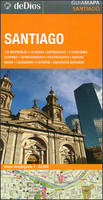
Santiago De Dios Map-Guide

Central districts of Santiago on a street plan highlighting 102 recommended attractions, colour-coded into best sights, restaurants, entertainment and shopping, all accompanied by brief descriptions, plus suggestions for a 48 hours visit to the city and other tourist information. On one side is a street plan of Santiago’s central districts, highlighting locations of the publishers’ recommendations. Metro stops are clearly marked, and the plan is accompanied by a diagram of Santiago’s metro network.. On the reverse, extensive tourist information includes notes describing various districts, suggestions for out-of-town excursions and 50 best “experiences”, a list of interesting events, etc. All the text is in Spanish only.
RIP - This product is no longer available on our network. It was last seen on 25.09.2019

This page now acts as a permanent archive for this product. Add more information using the comments box below to ensure it can still be found by future generations.

Use our search facility to see if it is available from an alternative contributor.
  • External links may include paid for promotion
  • Availability: Out Of Stock
  • Supplier: Stanfords
  • SKU: 9789871551934
Availability: In Stock
£11.99

Product Description

Central districts of Santiago on a street plan highlighting 102 recommended attractions, colour-coded into best sights, restaurants, entertainment & shopping, all accompanied by brief descriptions, plus suggestions for a 48 hours visit to the city & other tourist information. On one side is a street plan of Santiago’s central districts, highlighting locations of the publishers’ recommendations. Metro stops are clearly marked, & the plan is accompanied by a diagram of Santiago’s metro network.. On the reverse, extensive tourist information

Includes::
notes describing various districts, suggestions for out-of-town excursions & 50 best “experiences”, a list of interesting events, etc. All the text is in Spanish only.

Reviews/Comments

Add New

Intelligent Comparison

Oooops!
We couldn't find anything!
Perhaps this product's unique.... Or perhaps we are still looking for comparisons!
Click to bump this page and we'll hurry up.

Price History

Vouchers

No voucher codes found.
Do you know a voucher code for this product or supplier? Add it to Insights for others to use.

Facebook

Jargon Buster

Spanish - The main language spoken in Spain and Latin America.
Entertainment - Something that provides amusement
Colour - The categorised spectrum of light visable to humans
Network - A link and communication between things. Often computers or people.

Supplier Information

Stanfords
Stanfords was established in 1853 and opened their iconic Covent Garden flagship store in 1901. They have become the top retailer of maps, travel books and accessories in the UK and arguably offer the largest selection of maps and travel books worldwide. Famous names such as Captain Robert Falcon Scott, Ranulph Fiennes and Michael Palin have purchased from Stanfords. They now have a shop in Bristol and both stores together with other venues operate a calendar of events including talks, book signings and exhibitions. As a specialist map retailer, the map selection is comprehensive and includes road maps, street maps and walking maps from worldwide destinations, as well as a selection of world atlases and wall maps. Books include travel guides and travel literature. Stanfords also stock globes, from miniatures made of blue marble to magnificent floor-standing globes. The website features a selection of interesting articles on travel topics.
Page Updated: 2023-11-12 20:15:36

Community Generated Product Tags

Oh No! The productWIKI community hasn't generated any tags for this product yet!
Menu