
 United Kingdom
 France
 Germany
 Netherlands
 Sweden
 USA
USA
 Italy
Italy
 Spain
Spain
More From Contributor


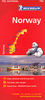
Norway K+F Road Map
Large, indexed map of Norway, presenting the whole country in two panels side by side. Clear, well-presented cartography has fine relief shading and spot heights to indicate the topography, with national parks prominently marked. Detailed presentation of the road network includes scenic routes, roads closed to traffic, seasonal closures of mountain passes, etc. Towns and places of particular interest are highlighted. The map has a latitude/longitude grid at intervals of 1º. Map legend includes English.The map also has an enlargement for the environs of Oslo and an inset showing Svalbard. An index of place names is attached to the map cover. North of Lillehammer coverage extends to include the neighbouring areas of Sweden and northern Finland.
Product Description
Reviews/Comments
Add New
Vouchers
No voucher codes found.
Do you know a voucher code for this product or supplier? Add it to Insights for others to use.
Do you know a voucher code for this product or supplier? Add it to Insights for others to use.
 Denmark