
 United Kingdom
 France
 Germany
 Netherlands
 Sweden
 USA
USA
 Italy
Italy
 Spain
Spain
More From Contributor


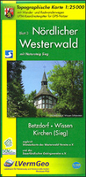
Northern Westerwald 3-Map Set
The northern part of the Westerwald hills along the border of Rhineland-Palatinate and North Rhine-Westphalia on a set of three maps in a series of contoured and GPS-compatible maps at 1:25, 000 with cartography of the German topographic survey and extensive overprint highlighting waymarked hiking trails and/or cycling routes, plus numerous recreational facilities including campsites, youth hostels, huts, Houses of Nature and other types of accommodation, sites for various outdoor pursuits, historic buildings and other cultural heritage, etc. The maps have a 1km UTM grid. Map legend and additional notes about the area are in German only.The northern part of the Westerwald is covered at 1:25, 000 by three maps, available either separately or as a set.Cartography in this recreational
series from the state survey organization of Rheinland-Pfalz is identical to the Germany’s official topographic survey and the maps provide all the information expected of survey mapping at this scale including landmarks, forest cover, etc. Contours are at 5m intervals, with additional relief shading. Many titles are double-sided to provide wider coverage on one map and/or include on the reverse additional tourist information. The maps have a UTM grid for GPS navigation. Most map legends now include English; additional tourist information such as route descriptions, notes about the region and its heritage, etc, vary – some are in German only.To see the list of titles in this series please click on the series link.
series from the state survey organization of Rheinland-Pfalz is identical to the Germany’s official topographic survey and the maps provide all the information expected of survey mapping at this scale including landmarks, forest cover, etc. Contours are at 5m intervals, with additional relief shading. Many titles are double-sided to provide wider coverage on one map and/or include on the reverse additional tourist information. The maps have a UTM grid for GPS navigation. Most map legends now include English; additional tourist information such as route descriptions, notes about the region and its heritage, etc, vary – some are in German only.To see the list of titles in this series please click on the series link.

Product Description
Reviews/Comments
Add New
Vouchers
No voucher codes found.
Do you know a voucher code for this product or supplier? Add it to Insights for others to use.
Do you know a voucher code for this product or supplier? Add it to Insights for others to use.
 Denmark