
 United Kingdom
 France
 Germany
 Netherlands
 Sweden
 USA
USA
 Italy
Italy
 Spain
Spain
More From Contributor

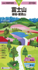


Mount Fuji
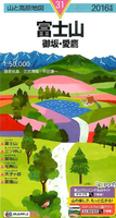
Mount Fuji, in Japanese, on an excellent map from Mapple providing topographic coverage at 1:50, 000/1:25, 000/1:10, 000 with hiking routes annotated in detail with ascent and descent times, plus maps of other nearby hiking areas. The map is printed on light, waterproof and tear resistant plastic paper.IMPORTANT – PLEASE NOTE BEFORE ORDERING: nearly all of the information in this title is in Japanese only, and so is the map legend. Only occasionally an important place name or names of well-known hiking routes name are also shown in the Latin alphabet.On one side a topographic map at 1:50, 000 with contours at 20m intervals and altitude colouring covers Mount Fuji and the area mainly to the north of it, including Lake Yamanakako, Lake Motusuko and Lake Saiko. Coverage is extended
further north beyond Lake Kawaguchiko by one of the panels on the reverse side. Hiking routes are highlighted and annotated with ascent and descent times, shown in detail for individual sections of the routes. On the reverse approaches to the summit of Mount Fuji from the north, east and south are shown enlarged to 1:25, 000, with the summit area itself presented at 1:10, 000. Also provided is a circular diagram showing names of other mountains and localities visible from the summit of Mount Fuji. Another panel at 1:50, 000 shows hiking routes around Mount Ashitakayama to the south of Mount Fuji. A further panel provides a road map at 1:300, 000 of the surrounding area indicating which sections of it are covered by the more detailed maps described above. The three maps at 1:50, 000 have
latitude at longitude lines at intervals of 1’. A separate 44-page booklet, in Japanese only, provides more information on the hiking routes.

Product Description
Reviews/Comments
Add New
Vouchers
No voucher codes found.
Do you know a voucher code for this product or supplier? Add it to Insights for others to use.
Do you know a voucher code for this product or supplier? Add it to Insights for others to use.
 Denmark