
 United Kingdom
 France
 Germany
 Netherlands
 Sweden
 USA
USA
 Italy
Italy
 Spain
Spain
More From Contributor

Morocco F&B
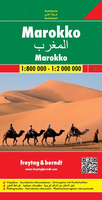
Morocco at 1:800, 000 with the Western Sahara at 1:2, 000, 000 on a large map from Freytag and Berndt with an index booklet attached to the cover providing street plans of central Casablanca, Fès, Marrakesh, Rabat/Salé and Tangier.Relief shading with spot heights, graphics for sandy or rocky deserts, swamps, seasonal streams, etc. show the topography. Road network includes desert tracks and indicates distances on main routes. Railway lines are included and local airports are marked. Places of interest including the country’s UNESCO World Heritage sites are highlighted. All place names are shown in the Latin alphabet only, except major cities which are also given their Arabic names. The map has latitude and longitude lines at intervals of 1°. Multilingual map legend includes
English.The index, in a separate booklet attached to the map cover shows most localities with their post codes and includes plans of central Casablanca, Fès, Marrakesh, Rabat/Salé and Tangier, naming main streets and indicating principal traffic arteries.
English.The index, in a separate booklet attached to the map cover shows most localities with their post codes and includes plans of central Casablanca, Fès, Marrakesh, Rabat/Salé and Tangier, naming main streets and indicating principal traffic arteries.

Product Description
Reviews/Comments
Add New
Vouchers
No voucher codes found.
Do you know a voucher code for this product or supplier? Add it to Insights for others to use.
Do you know a voucher code for this product or supplier? Add it to Insights for others to use.
 Denmark