
 United Kingdom
 France
 Germany
 Netherlands
 Sweden
 USA
USA
 Italy
Italy
 Spain
Spain
More From Contributor


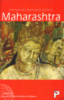
Maharashtra Map-Guide
Indian state of Maharashtra on road map from the Delhi-based International Publications, showing many small towns and villages, with a 38-page booklet describing the state and its sights. Additional features include an enlargement showing in greater detail road and railway connections around Mumbai; a physical map of the state with altitude colouring; a distance chart; a table listing administrative units with size, population, literacy, etc. Illustrated booklet includes notes on beaches and hill stations, fairs and festivals, pilgrimage pales, wildlife, etc.Unless indicated to the contrary in the individual description, maps in this series present the state with its constituent districts in different colours and also show the division of districts into talukas. Town symbols
indicate both district and taluka headquarters. Road network includes many local roads, some with driving distances, although sometimes locations are marked without road access to them shown on the map. Railway lines are included and local airports are marked. Symbols indicate various locations of interest, including historical sites, wildlife sanctuaries, beaches, etc.In many titles additional panels around the main map and/or in the accompanying booklet provide more information: enlargements with more detailed presentation of the road network, street plans of main cities, etc. The booklets, which also include a general introduction to the state and district-by-district descriptions, are published on high quality paper and are illustrated with numerous colour photos.To see the
list of titles in this series please click on the series link.

Product Description
Reviews/Comments
Add New
Vouchers
No voucher codes found.
Do you know a voucher code for this product or supplier? Add it to Insights for others to use.
Do you know a voucher code for this product or supplier? Add it to Insights for others to use.
 Denmark