More From Contributor

£11.50
Topographic survey of France at 1:25, 000 in IGN`s excellent TOP25 / Série Bleue series. All the maps are GPS compatible, with a 1km UTM grid plus latitude & longitude lines at 5’ intervals. Contours are at 5m intervals except for mountainous areas where the maps have contours at 10m intervals, vividly enhanced by hill shading & graphics for rocky terrain. Colouring with graphics indicates different types of vegetation or land use (deciduous or coniferous forests, moors, orchards, vineyards, etc). PLEASE NOTE: coverage of France at this scale is currently being revised – the format & the presentation of each title are indicated by the letters at the end of its Sheet Reference number (e.g. 0416ET, 3531ETR, 1923SB, etc.)MAPS WITH FULL TOURIST OVERPRINT & AN ENGLISH MAP LEGEND: all TOP25 maps & the SB editions of Série Bleue have an overprint highlighting waymarked walking trails including long-distance GR routes &, where appropriate, ski routes. Symbols indicate campsites, gîtes d’etape, refuges, equestrian centres & other recreational facilities or sites, tourist information centres, cultural heritage, etc. Towns & locations of particular interest are highlighted.- ET or OT = single-sided TOP25 map covering approx. 29x 21 km / 18x 13 miles.- ETR or OTR = waterproof & tear resistant TOP25 map covering the same area as the corresponding ET or OT number, but double-sided, printed on a smaller size sheet with a good overlap between the sides.- SB = Série Bleue map with full tourist overprint; these maps, first introduced in summer 2014, each cover approx. 29x 24km / 18x 15 miles.SÉRIE BLEUE maps with numbers ending in E (Est) or O (Ouest): most editions now indicate the GR routes, but do not show any other tourist information. Map legend is in French only. Each map covers approx. 14x 20km / 9x 12 miles. ...
Archived Product
£3.50
Jarrow in 1912 in a fascinating series of reproductions of old Ordnance Survey plans in the Alan Godfrey Editions, ideal for anyone interested in the history of their neighbourhood or family. Coverage starts at Randolph Street & Pearson Place & continues into Hebburn through to St Cuthbert`s Church. Features include Hebburn Colliery, Jarrow Park, NER Railway line & station, St Oswalds Church & Tyne Lead Works. Main streets include Western Road, Argyle Street, Albert Road, Victoria Road & Wagonway Road. On the reverse is an extract from a directory for the area. About the Alan Godfrey Editions of the 25” OS Series: Selected towns in Great Britain & Ireland are covered by maps showing the extent of urban development in the last decades of the 19th & early 20th century. The plans have been taken from the Ordnance Survey mapping & reprinted at about 15 inches to one mile (1:4, 340). On the reverse most maps have historical notes & many also include extracts from contemporary directories. Most maps cover about one mile (1.6kms) north/south, one & a half miles (2.4kms) across; adjoining sheets can be combined to provide wider coverage.FOR MORE INFORMATION & A COMPLETE LIST OF ALL AVAILABLE TITLES PLEASE CLICK ON THE SERIES LINK. ...
Archived Product
£7.99
Nicola Naylor had always been enthralled by India, but her travel fantasies dissolved when she lost her sight. Overcoming her own private fears & disregarding the warnings, Naylor set out to experience India alone. This is the inspiring account of her unique journey. Told with a vivid & evocative insight, Jasmine & Arnica is a story of a young woman`s determination, a celebration of the power of vision, beyond sight, to reveal what`s closest to the heart, & to uncover life`s most precious, unseen joys. ...
Archived Product
£9.99
Now in a riveting new verse translation Jason & the Argonauts (also known as the Argonautica), is the only surviving full account of Jason`s voyage on the Argo in quest of the Golden Fleece aided by the sorceress princess Medea. Written in third century B.C., this epic story of one of the most beloved heroes of Greek mythology, with its combination of the fantastical & the real, its engagement with traditions of science, astronomy & medicine, winged heroes, & a magical vessel that speaks, is truly without exact parallel in classical or contemporary Greek literature & is now available in an accessible & engaging translation. Apollonius of Rhodes published his first version of the Argonautica sometime in the middle of the third century B.C. At the end of his life he was director of the famous Library of Alexandria, which was the principal storehouse of all literature & learning at the time. Aaron Poochigian, born in 1973, is a poet & an associated lecturer in Classics at The Ohio State University & has translated the Penguin Classics edition of Stung with Love: Poems & Fragments by Sappho, as well as works by Aeschylus & Aratus. He lives in New York City. Benjamin Acosta-Hughes is Professor of Greek & Latin at The Ohio State University. He is the author of several works of nonfiction, including Arion`s Lyre: Archaic Lyric into Hellenistic Poetry. ...
Archived Product
£7.99
Award-winning children's author James Riordan boldly retells this story from Greek mythology, introducing readers to the first great European hero to undertake a grand journey. Accompanied by some of ancient Greece's bravest heroes, Jason leads an expedition to retrieve the Golden Fleece, the property of a king in a far-off l&. Traveling by sea, they encounter trial after trial along their route
- shrieking Harpies, deadly clashing rocks, & fierce Amazon warrior women
- & yet more challenges await them at their destination. For before he will give up the fleece, the king devises a test for Jason that will certainly be the death of him
- unless the king's daughter, Medea, agrees out of love for Jason to lend him her magical powers. This is a classic tale of high adventure that holds appeal for boys & girls alike.


...
Archived Product
£10.95
Jasper
- Maligne Lake in a series of detailed hiking maps of the Canadian Rockies, covering the most popular areas of the Banff,
...
Archived Product
£14.95
Jasper
- Maligne Lake in a series of detailed hiking maps of the Canadian Rockies, covering the most popular areas of the Banff,
...
Archived Product
£7.99
Summer, 1965. Late one night, thirteen-year-old Charlie Bucktin is startled by a knock on his window. His visitor is Jasper Jones. Rebellious, mixed-race & solitary, Jasper is intriguing. & he needs Charlie`s help. In the dead of night, the boys steal through town, & Charlie learns of Jasper`s horrible discovery. Burdened by a terrible secret & the weight of a town`s suspicion, Charlie feels his world closing in. After this summer nothing will ever be the same again. ...
Archived Product
£9.99
Jasper National Park & Northern Alberta on a double-sided map from ITMB combining coverage of the park with mapping from the Canadian topographic survey at 1:250, 000 & a road map of northern part of Alberta province at 1:1, 000, 000 showing access to the park from Edmonton. On one side is coverage of the Jasper National Park & the adjoining Mount Robson Provincial Park in British Columbia presented on mapping at 1:250, 000 from the Canadian topographic survey. Contour lines are at 200 feet intervals below 5000 feet & at 500 above that level. Additional overprint, mainly along the Icefield Parkway & the Yellowhead Highway, highlights campsites & other tourist accommodation. The map has a 10km UTM grid plus margin ticks for latitude & longitude at 15’ intervals. An inset shows a street plan of Jasper indicating accommodation, restaurants & other places of interest. On the reverse is an indexed road map of northern Alberta showing access to the park from Edmonton. Altitude colouring shows the topography. Symbols highlight various places of interest including other protected areas, campsites, etc. Also provided is a street plan of central Edmonton. To see other titles in this series please click on the series link. ...
Archived Product
£9.99
The northern part of the Jasper National Park on a double-sided, contoured, GPS compatible recreational map at 1:100, 000 from the National Geographic printed on light, waterproof & tear-resistant synthetic paper. Coverage extends along the Icefields Parkway from Jasper Village & the Yellowhead Highway to the northern boundary of the park. This title is part of a series of four recreational maps of the Banff & Jasper National Parks from the National Geographic Society. Each map is double-sided to cover a wider area. Topography is very vividly presented by contours at 30m intervals enhanced by relief shading & altitude colouring. Heights are given both in feet & metres. Boundaries of the region’s numerous protected areas indicate their official status, from national parks to provincial natural areas. Road network shows enhanced roads, routes requiring high clearance vehicles & restricted access administrative roads. The marking for maintained trails differentiates between routes for hiking & horse riding & those also suitable for bikes. The trails are annotated with distances in both miles & kilometres. A very wide range of symbols highlights local facilities & recreational areas: different types of accommodation including campgrounds, cabins & hostels, parking & picnic areas, trailheads, horse riding facilities, boat tours, etc. The maps have a 1-km UTM grid plus latitude & longitude crosshairs at 10’. Each title also

Includes::
general information about the region, safety tips, & useful contact details.

...
Archived Product

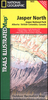
Jasper & Maligne Lake Gem Trek

Jasper - Maligne Lake area of the Jasper National Park at 1:100, 000 on a GPS compatible, waterproof and tear-resistant map from Gem Trek, with very extensive tourist information including recommendations for day or longer hikes, mountain biking trails, notes on camping permits, more detailed enlargements, etc.The map covers the most popular hiking and mountain biking terrain in the Jasper National Park, extending from the Pocahontas Station in the north to Fortress Lake in the south, west beyond Jasper Townsite to Mount Fraser, and east to Coronet Creek at the southern tip of Lake Maligne. The map has contours at 50m intervals, vividly enhanced by relief shading, colouring and spot heights (given in metres and feet). An overprint highlights hiking and/or mountain biking and/or
horse riding trails, indicating less well maintained routes, several types of tourist accommodation, picnic areas, viewpoints, etc. The map has a 1km UTM grid. On the reverse is extensive tourist information. 20 descriptions of day hikes cover trails from various locations: near or south of Jasper Town, Mt. Edith Cavell, Maligne Road and Lake, Miette Hot Springs. Also provided are suggestions for two- or three-day trips. Eight recommendations for mountain biking trails are graded according to difficulty. Enlargements show in greater detail Jasper Townsite, facilities at the northern end of Maligne Lake, plus Maligne Canyon. Also provided is information about backcountry camping permits, useful contact numbers, etc.To see the full list of all the titles in this series please
click on the series link.
RIP - This product is no longer available on our network. It was last seen on 25.09.2019

This page now acts as a permanent archive for this product. Add more information using the comments box below to ensure it can still be found by future generations.

Use our search facility to see if it is available from an alternative contributor.
  • External links may include paid for promotion
  • Availability: Out Of Stock
  • Supplier: Stanfords
  • SKU: 9781895526882
Availability: In Stock
£14.99

Product Description

Jasper
- Maligne Lake area of the Jasper National Park at 1:100, 000 on a GPS compatible, waterproof & tear-resistant map from Gem Trek, with very extensive tourist information including recommendations for day or longer hikes, mountain biking trails, notes on camping permits, more detailed enlargements, etc. The map covers the most popular hiking & mountain biking terrain in the Jasper National Park, extending from the Pocahontas Station in the north to Fortress Lake in the south, west beyond Jasper Townsite to Mount Fraser, & east to Coronet Creek at the southern tip of Lake Maligne. The map has contours at 50m intervals, vividly enhanced by relief shading, colouring & spot heights (given in metres & feet). An overprint highlights hiking and/or mountain biking and/or horse riding trails, indicating less well maintained routes, several types of tourist accommodation, picnic areas, viewpoints, etc. The map has a 1km UTM grid. On the reverse is extensive tourist information. 20 descriptions of day hikes cover trails from various locations: near or south of Jasper Town, Mt. Edith Cavell, Maligne Road & Lake, Miette Hot Springs. Also provided are suggestions for two- or three-day trips. Eight recommendations for mountain biking trails are graded according to difficulty. Enlargements show in greater detail Jasper Townsite, facilities at the northern end of Maligne Lake, plus Maligne Canyon. Also provided is information about backcountry camping permits, useful contact numbers, etc. To see the full list of all the titles in this series please click on the series link.

Reviews/Comments

Add New

Intelligent Comparison

Oooops!
We couldn't find anything!
Perhaps this product's unique.... Or perhaps we are still looking for comparisons!
Click to bump this page and we'll hurry up.

Price History

Vouchers

No voucher codes found.
Do you know a voucher code for this product or supplier? Add it to Insights for others to use.

Facebook

Jargon Buster

GPS - Global Positioning System - Global position using satellites
Hiking - An outdoor activity envolving walking in nature
Metres - A unit of measure, one metre equals 100 centimetres
hot - An indication of the temperature being high and a sensation of heat to the tough
Waterproof - Resistant to water, usualy specified by depth in metres
Day - The time it takes a planet or other space objects to complete one rotation.
Road - a manmade lane or a path that is used to speed up travel.
Resistant - Something that can repel against something.
Horse - A large animal with four legs that tends to be ridden.
Accommodation - A room in which someone can live in, for example in a hotel
Popular - Something that is admired and liked by many people.

Supplier Information

Stanfords
Stanfords was established in 1853 and opened their iconic Covent Garden flagship store in 1901. They have become the top retailer of maps, travel books and accessories in the UK and arguably offer the largest selection of maps and travel books worldwide. Famous names such as Captain Robert Falcon Scott, Ranulph Fiennes and Michael Palin have purchased from Stanfords. They now have a shop in Bristol and both stores together with other venues operate a calendar of events including talks, book signings and exhibitions. As a specialist map retailer, the map selection is comprehensive and includes road maps, street maps and walking maps from worldwide destinations, as well as a selection of world atlases and wall maps. Books include travel guides and travel literature. Stanfords also stock globes, from miniatures made of blue marble to magnificent floor-standing globes. The website features a selection of interesting articles on travel topics.
Page Updated: 2023-11-12 20:15:36

Community Generated Product Tags

Oh No! The productWIKI community hasn't generated any tags for this product yet!
Menu