
 United Kingdom
 France
 Germany
 Netherlands
 Sweden
 USA
USA
 Italy
Italy
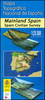
 Spain
Spain
More From Contributor


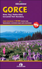


Gorce
Gorczanski National Park in a series of detailed maps of Poland’s most popular recreational areas, showing waymarked hiking and cycling routes and various types of overnight accommodation, including local hotels, youth hostels, shelters and mountain huts, campsites, camping on local farms, etc. The maps also show various sport and recreational facilities: swimming pools, equestrian and watersport centres, etc. A wide range of other symbols highlight places of interest, local restaurants and bars, fuels supplies and other facilities. The base map is contoured (interval 5m, 10m, or 20m depending on the terrain), with, where appropriate, relief shading and graphic relief to enhance the presentation of the terrain. The maps also indicate various types of vegetation or land
use. Road network includes unsurfaced country tracks and railway lines show local stations. The maps have 1km UTM grid. *Map legend includes English.**In this title:* one of the most beautiful parts of the Beskidy Mountains with the Gorczanski National Park. The map covers an area from the Sieniawska Pass and Raba Wyzna in the west to the valley of the Dunajec and Kroscienko nad Dunajcem in the east. Coverage north/south is from Mszana Dolna to the Czorsztynskie Lake in the south. Information on the reverse includes lists of various types of accommodation, including mountain shelters, hotels and pensions, agritourist farms, etc., all with contact details. Descriptions of the area, accompanied by colour photos are in Polish only.
use. Road network includes unsurfaced country tracks and railway lines show local stations. The maps have 1km UTM grid. *Map legend includes English.**In this title:* one of the most beautiful parts of the Beskidy Mountains with the Gorczanski National Park. The map covers an area from the Sieniawska Pass and Raba Wyzna in the west to the valley of the Dunajec and Kroscienko nad Dunajcem in the east. Coverage north/south is from Mszana Dolna to the Czorsztynskie Lake in the south. Information on the reverse includes lists of various types of accommodation, including mountain shelters, hotels and pensions, agritourist farms, etc., all with contact details. Descriptions of the area, accompanied by colour photos are in Polish only.

Product Description
Reviews/Comments
Add New
Vouchers
No voucher codes found.
Do you know a voucher code for this product or supplier? Add it to Insights for others to use.
Do you know a voucher code for this product or supplier? Add it to Insights for others to use.
 Denmark