
 United Kingdom
 France
 Germany
 Netherlands
 Sweden
 USA
USA
 Italy
Italy
 Spain
Spain
More From Contributor


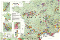
France Wine Wall Map
France Wine Wall Map from De Long Company, size 61 x 92 cm / 24” x 36”, presents in an attractive pastel colouring the country’s wine regions according to their official classifications: AOC, AOP, VDP/IGP and VDF. Colouring and graphics are carefully designed to show overlapping zones. The base map has colouring according the mean annual temperature, with graphics to indicate mountainous and/or forested areas, main rivers and roads, plus selected towns and locations within the wine regions. Insets present in greater detail sub-zones of Bordeaux and two areas of Burgundy: Côte d’Or and Beaujolais. Colouring and graphics extend to show wine regions in the adjoining areas of Germany, Switzerland, Italy and Spain. For general reference, there is also a small map of France
showing the country’s main wine growing regions. An interesting feature is the inclusion of latitude lines to provide comparisons with other wine growing areas, e.g. at 46°06’ Beaujolais is at the same latitude as the Walla Walla Valley in Washington State. The map is supplied with a separate brochure which includes two indexes: by region, plus alphabetically by the AOC/AOP names. Map legend and all the text are in English.
showing the country’s main wine growing regions. An interesting feature is the inclusion of latitude lines to provide comparisons with other wine growing areas, e.g. at 46°06’ Beaujolais is at the same latitude as the Walla Walla Valley in Washington State. The map is supplied with a separate brochure which includes two indexes: by region, plus alphabetically by the AOC/AOP names. Map legend and all the text are in English.

Product Description
Reviews/Comments
Add New
Vouchers
No voucher codes found.
Do you know a voucher code for this product or supplier? Add it to Insights for others to use.
Do you know a voucher code for this product or supplier? Add it to Insights for others to use.
 Denmark