
 United Kingdom
 France
 Germany
 Netherlands
 Sweden
 USA
USA
 Italy
Italy
 Spain
Spain
More From Contributor


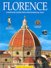

Florence Michelin City Map
Michelin’s street plan of Florence at 1:10, 000 is primarily designed to be used for access to and travel across the city by car, given its wide coverage of the outer suburbs, including Fiesole, and detailed presentation of the surrounding motorway network. The city’s historic centre is shown on the reverse enlarged to 1:5, 000.Main traffic routes are highlighted and motorway junctions are clearly laid out. One way streets and car parks are marked. The plan also indicates what appear to be locations of petrol station, although no reference is made to it in its legend. Public buildings and various facilities, including churches, museums, etc, are highlighted and named, but without particular emphasis on popular tourist sights. Map legend which includes English and the street
index are on the reverse side, together with a road map of the city’s environs at 1:150, 000.PLEASE NOTE: the choice of type face and the placing of street names make some parts of the plan more difficult to read than may appear from our sample.To see the list of titles in this series please click on the series link.
index are on the reverse side, together with a road map of the city’s environs at 1:150, 000.PLEASE NOTE: the choice of type face and the placing of street names make some parts of the plan more difficult to read than may appear from our sample.To see the list of titles in this series please click on the series link.

Product Description
Reviews/Comments
Add New
Vouchers
No voucher codes found.
Do you know a voucher code for this product or supplier? Add it to Insights for others to use.
Do you know a voucher code for this product or supplier? Add it to Insights for others to use.
 Denmark