More From Contributor

£6.99
Europe on a very large double-sided, indexed map from Insight Guides covering most of the continent at 1:2, 500, 000, with western Russia, eastern Ukraine & Turkey shown at 1:4, 500, 000. The map provides an overview of the road network: main railway lines & ferry routes are also included. Locations of interest are prominently highlighted. A very wide range of symbols indicate sights of natural or geographical interest including national parks, historical or archaeological remains, remarkable buildings, etc. The map has latitude & longitude lines at intervals of 1 ...
Archived Product
£14.99
Collected here for the first time are some of the numerous essays & lectures by Norman Davies, author of the bestselling & critically acclaimed Europe, The Isles & Rising '44. Spanning more than fifteen years of his remarkable career, this highly accessible collection addresses many of the issues that continue to dominate the political & cultural climate of Europe today. From the classical origins of the idea of Europe to the division between East & West during the Cold War; from the Jewish & Islamic strands in European history to the expansion of Europe to other continents; from the misunderstood Allied victory in 1945 to Britain's place in Europe; from reflections on the use & abuse of history to personal recollections on learning languages
- this companion volume to the bestselling Europe looks at European history from a variety of unusual & entertaining angles in an equally stimulating & accessible way.
...
Archived Product
£10.99
Double-sided, political road map encomapssing a large area. One side depicts Eastern Europe from the Crimea to Karelia, & from Gdansk in Poland to Nisjnij Novgorod in Russia. South-west Finland is excluded, but there is an inset at 1:3, 000, 000 showing the Kola Peninsula region. The reverse side reaches further into Russia, extending from Moscow & Rostov-na-Donu to the Urals, & from the Caucasus region to Syktyvkar in the north. The Caucasus region is portrayed in an inset. Main roads & railways are clearly drawn, & intermediate driving distances are marked on the map. Administrative districts & border checkpoints are marked, & different symbols are used to classify towns according to population size. Territories with undefined political status are highlighted, eg. Nagorno Karabakh. Hill shading gives an impression of the relief. Latitude & longitude lines are drawn at 2degree intervals. Place names are in Roman alphabet only & the map legend

Includes::
English, but there is no index.

...
Archived Product
£10.99
Eastern Europe at 1:2, 000, 000 from Freytag & Berndt, with a separate 72-page booklet with an extensive index listing locations with postcodes plus providing street plans of central areas in the region’s 12 capital cities. The map shows road & rail networks at the level appropriate to its scale, clearly indicating on main routes their road numbers, including where appropriate the E-numbers. Also marked are ferry connections, local airports, & within larger countries internal administrative boundaries. Within the countries using the Cyrillic & in Greece names of larger town are given in both Latin & local alphabet. Latitude/longitude grid is drawn at intervals of 1º. Map legend

Includes::
English. The index, arranged by country & showing locations with their postcodes, is in a separate booklet attached to the map cover. The booklet also

Includes::
street plans of city centres in 12 capitals: Athens, Belgrade, Budapest, Bucharest, Kiev, Minsk, Moscow, Riga, Sofia, Tallinn, Vilnius & Warsaw. All street names are is Latin alphabet.


...
Archived Product
£24.99
Wall map of wine producing regions of western, central & southern Europe from Editions Benoit. A different colour is used for each country to highlight its wine growing regions & a table gives overall production figures. Information is provided only for the regions up the eastern border of Germany & the northern borders of the Czech Republic, Slovakia, Hungary & Romania. Areas outside that line, e.g. the vineyards of southern Ukraine are not included.A base with shading for mountain chains & main towns is overprinted with colours highlighting wine growing areas. Principal wine producing regions are named, although the degree of detail varies from country to country; more, inevitably, in France where regions such as Bordeaux or Burgundy are divided into sectors (Médoc, Graves, Côte de Nuits, Maconnais, etc.), whilst in Italy only names of administrative regions are given, i.e. Tuscany but not Chianti (no colouring within England although Sussex & Essex are designated as wine growing regions). Also included is a table showing various wine production figures both for the counties covered by the map & for the remaining European wine producers. All information is in French. ...
Archived Product
£29.00
Dirk Leyman became interested at a very young age in these peculiar accordion postcard albums, which every self-respecting tourist & souvenir hunter used to take home from their holiday. Dirk started to systematically collect them as time went by. The snapshots, which are folded in zig-zag fashion, are like relics of a long-gone era. Some are veritable typographical & photographic gems. Others are borderline kitsch, with their heavy-handed use of colour. Europe Express spans the decades between the two World Wars to the early Eighties, with photos of San Marco in Venice & the elegant Grand Hotels & the utopian, upstanding world of the former Soviet Union. ...
Archived Product
£19.99
Europe Eyewitness travel guide from Dorling Kindersley is a lavishly illustrated book concerned with providing the visitor with detailed background information to Europe's key sightseeing destinations & a broad cultural introduction to each country. Popular historical buildings & museums are often described with cutaway diagrams allowing you to view ...
Archived Product
£19.99
Europe Eyewitness travel guide from Dorling Kindersley is a lavishly illustrated book concerned with providing the visitor with detailed background information to Europe`s key sightseeing destinations & a broad cultural introduction to each country. Popular historical buildings & museums are often described with cutaway diagrams allowing you to view “inside” your destination, sites are shown with bird’s eye plans & small, more conventional maps contextualise regions & pinpoint places of interest. The guide is grouped into regions of The British Isles, France & the Low Countries, Iberian Peninsula, Italy & Greece, Germany, Austria & Switzerl&, Scandinavia, Central & Eastern Europe. A selection of places to stay & places to eat have been given for each nation, often divided into venues within popular city destinations of each country. Practical travel information is provided in the introduction & a simple plan of Europe`s rail network is shown inside the back cover. ...
Archived Product
£9.99
Compact Road Atlas of Europe from Freytag & Berndt in an A4 paperback format, with coverage at 1:1, 500, 000 for route planning extending east beyond Moscow & to include the Aegean coast of Turkey. Plus town centre street plans of most capital cities within the coverage area. The atlas presents the network of main & selected secondary & local roads on a base with relief shading & colouring for forested regions. Driving distances are marked on main routes. Place names, particularly of main towns, are in larger size print that found in most mapping at this scale, but this unfortunately obscures the road network & other information within areas such as the Ruhr, the Netherlands, Paris or London conurbations, etc. Outside these densely populated areas the mapping is much clearer. Within Greece & countries using the Cyrillic alphabet names of larger towns are in the local & Latin alphabets. The maps have latitude & longitude lines at 1° intervals. The index, which

Includes::
postcodes, is arranged by country. The atlas also

Includes::
34 one- or two-page city centre street plans of European capitals plus Istanbul (no plans of Sofia, Tirana, Skopje, Podgorica, Pristina & Chisinau). Map legend

Includes::
English.


...
Archived Product

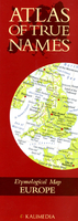
Europe Etymological Map (Atlas Of True Names)

The Atlas of True Names reveals the etymological roots, or original meanings, of the familiar terms on today`s map of Europe. For instance, where you would normally expect to see London indicated, the ‘Atlas’ gives you ”Hillfort. The `True Names` of 1500 cities, countries, rivers, oceans and mountain ranges are displayed on this fascinating map, which includes a comprehensive index of derivations.Etymology is the study of the origin and history of words. For the first time, the Atlas of True Names uses etymology to give us an unusual insight into familiar geographical names - with intriguing results......Many geographical names are clearly rooted in Man’s observation of his natural environment; the physical location of a settlement: “At the Foot of the Mountain” -
Piedmont, the character of an important water course: “The Gentle One” - The Seine or even just the local vegetation: “Under the Oaks” - Potsdam.Unsurprisingly, countries and landscapes often derive their names from the characteristics of the people who lived there: “Great Land of the Tattooed” - Great Britain, whilst local mythology and regional rulers also frequently leave their legacy: “Isle of the Monster’s Eye” - Peleponnese or “Illustrious Emperor” - Zaragoza.The Atlas of True Names restores an element of enchantment to the world we all think we know so well. It takes the reader on a journey into the unknown - a unique exploration of uncharted territory in that familiar place we all know as ‘home’.Take a look at the world through fresh eyes!
RIP - This product is no longer available on our network. It was last seen on 25.09.2019

This page now acts as a permanent archive for this product. Add more information using the comments box below to ensure it can still be found by future generations.

Use our search facility to see if it is available from an alternative contributor.
  • Availability: Out Of Stock
  • Supplier: Stanfords
  • SKU: 9780755830008
Availability: In Stock
£4.99

Product Description

The Atlas of True Names reveals the etymological roots, or original meanings, of the familiar terms on today`s map of Europe. For instance, where you would normally expect to see London indicated, the ‘ Atlas’ gives you ” Hillfort. The ` True Names` of 1500 cities, countries, rivers, oceans & mountain ranges are displayed on this fascinating map, which

Includes::
a comprehensive index of derivations. Etymology is the study of the origin & history of words. For the first time, the Atlas of True Names uses etymology to give us an unusual insight into familiar geographical names
- with intriguing results...... Many geographical names are clearly rooted in Man’s observation of his natural environment; the physical location of a settlement: “ At the Foot of the Mountain”
- Piedmont, the character of an important water course: “ The Gentle One”
- The Seine or even just the local vegetation: “ Under the Oaks”
- Potsdam. Unsurprisingly, countries & landscapes often derive their names from the characteristics of the people who lived there: “ Great Land of the Tattooed”
- Great Britain, whilst local mythology & regional rulers also frequently leave their legacy: “ Isle of the Monster’s Eye”
- Peleponnese or “ Illustrious Emperor”
- Zaragoza. The Atlas of True Names restores an element of enchantment to the world we all think we know so well. It takes the reader on a journey into the unknown
- a unique exploration of uncharted territory in that familiar place we all know as ‘home’. Take a look at the world through fresh eyes!

Reviews/Comments

Add New

Intelligent Comparison

Oooops!
We couldn't find anything!
Perhaps this product's unique.... Or perhaps we are still looking for comparisons!
Click to bump this page and we'll hurry up.

Price History

Vouchers

No voucher codes found.
Do you know a voucher code for this product or supplier? Add it to Insights for others to use.

Facebook

Jargon Buster

Eye - An organ which detects light
Foot - A part of the body at the bottom end of the leg
Foot - or Feet - a measurement equivilent to 30cm
water - A chemical substance. Chemical formula H2O.
Physical - Used to describe strength or visual properties of an item
History - Anything that happens in the past. An acedemic subject.
World - A physical grouping, commonly used to describe earth and everything associated with ti
Natural - not manmade
Unusual - Something unique and different.
Home - A place of permanent residence for families.
Regional - An adjective to describe a set geographic area.
Environment - The conditions and surrounding area.

Supplier Information

Stanfords
Stanfords was established in 1853 and opened their iconic Covent Garden flagship store in 1901. They have become the top retailer of maps, travel books and accessories in the UK and arguably offer the largest selection of maps and travel books worldwide. Famous names such as Captain Robert Falcon Scott, Ranulph Fiennes and Michael Palin have purchased from Stanfords. They now have a shop in Bristol and both stores together with other venues operate a calendar of events including talks, book signings and exhibitions. As a specialist map retailer, the map selection is comprehensive and includes road maps, street maps and walking maps from worldwide destinations, as well as a selection of world atlases and wall maps. Books include travel guides and travel literature. Stanfords also stock globes, from miniatures made of blue marble to magnificent floor-standing globes. The website features a selection of interesting articles on travel topics.
Page Updated: 2023-11-12 20:15:36

Community Generated Product Tags

Oh No! The productWIKI community hasn't generated any tags for this product yet!
Menu