
 United Kingdom
 France
 Germany
 Netherlands
 Sweden
 USA
USA
 Italy
Italy
 Spain
Spain
More From Contributor


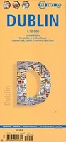
Dublin Borch
Central districts of Dublin on a laminated and waterproof tourist plan from Borch, with an enlargement for the city centre, a plan of Phoenix Park, and road maps of the capital’s environs and of the whole of the east coast between Dundalk and Waterford. The main plan at 1:12, 000 extends from Dublin Bay Passenger and Ferry Terminal to Phoenix Park, with the park itself shown on the reverse at 1:25, 000. Coverage north/south extends from Drumcondra and Marino districts to the Grand Canal. On the reverse the city centre, the Temple Bar and Grafton Street area, is shown in greater detail at 1:10, 000. The plans shows metro stations, one way street and car parks, public buildings and places of interest, selected hotels, etc.The whole of the city and its environs are shown at 1:125,
000. A road map at 1:700, 000 shows the eastern coast of Ireland from Dundalk to Waterford, extending inland to beyond Kilkenny and Carrick-on-Suir and highlighting places of interest, golf courses, etc. All the plans and the road maps are indexed for streets/localities, places of interest, shopping centres, parks, etc. Also included is a diagram of the metro and suburban rail connections, and information on the city’s climate.
000. A road map at 1:700, 000 shows the eastern coast of Ireland from Dundalk to Waterford, extending inland to beyond Kilkenny and Carrick-on-Suir and highlighting places of interest, golf courses, etc. All the plans and the road maps are indexed for streets/localities, places of interest, shopping centres, parks, etc. Also included is a diagram of the metro and suburban rail connections, and information on the city’s climate.

Product Description
Reviews/Comments
Add New
Vouchers
No voucher codes found.
Do you know a voucher code for this product or supplier? Add it to Insights for others to use.
Do you know a voucher code for this product or supplier? Add it to Insights for others to use.
 Denmark