
 United Kingdom
 France
 Germany
 Netherlands
 Sweden
 USA
USA
 Italy
Italy
 Spain
Spain
More From Contributor


Argentina Borch
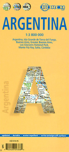
Laminated, waterproof tourist map of Argentina from Borch, with street plans of central Buenos Aires, Córdoba and Salta, plus enlargements for the environs of the capital, Los Glaciares National Park and Tierra del Fuego. The main map presents the whole of the country at 1:3, 800, 000, with its north-eastern tip leading to the Iguazú Falls as an inset, and highlights numerous national parks and protected areas, as well as places of interest. Road network includes many minor roads and tracks. Topography is shown by relief shading and spot heights, with names of mountain and hill ranges and main peaks. Coverage extends to the Pacific Coast to include Chile south of Calama, with similar information as for Argentina.The environs of Buenos Aires are shown at 1:600, 000. Further
enlargements cover the Los Glaciares National Park (1:750, 000, plus Monte Fitz Roy area at 1:250, 000), and Tierra del Fuego (1:1, 900, 000, plus Ushuaia National Park at 1:500, 000) with additional symbols for selected accommodation and campsites.Also included are street plans of central Buenos Aires, Córdoba and Salta, annotated with places of interest and various facilities. All the maps and the street plans are indexed, with separate lists for accommodation, places of interest, etc. Map legend includes English. Also provided is an administrative map showing the division of Argentina into provinces and climate charts with average monthly temperature, precipitation, etc.
enlargements cover the Los Glaciares National Park (1:750, 000, plus Monte Fitz Roy area at 1:250, 000), and Tierra del Fuego (1:1, 900, 000, plus Ushuaia National Park at 1:500, 000) with additional symbols for selected accommodation and campsites.Also included are street plans of central Buenos Aires, Córdoba and Salta, annotated with places of interest and various facilities. All the maps and the street plans are indexed, with separate lists for accommodation, places of interest, etc. Map legend includes English. Also provided is an administrative map showing the division of Argentina into provinces and climate charts with average monthly temperature, precipitation, etc.

Product Description
Reviews/Comments
Add New
Vouchers
No voucher codes found.
Do you know a voucher code for this product or supplier? Add it to Insights for others to use.
Do you know a voucher code for this product or supplier? Add it to Insights for others to use.
 Denmark