More From Contributor

£10.99
Alpi Giulie Occidentali – Tarvisiano area in a series of Tabacco maps at 1:25, 000 covering the Dolomites & the mountains of north-eastern Italy
- Stanfords’ most popular coverage for this region, with excellent cartography & extensive overprint for hiking routes & other recreational activities, local bus stops, etc. Additional overprint in this title shows ski routes. To see the list of titles in this series please click on the series link. Maps in the Tabacco 25K series have contours at 25m intervals, shading & graphic relief to provide a vivid picture of the topography. An overprint highlights local footpaths as well as long-distance trails including all the Alte Vie (the Dolomites high level routes), indicating the degree of difficulty, the state of waymarking, & the ”via ferrata” sections. Most titles now also highlight cycling routes & mountain bike trails; some also include ski routes. Six different types of accommodation are marked, from isolated hotels & inns to campsites & refuges, local bus stops, cable car lines & chair lifts, plus places of interest & sport facilities. Unless indicated to the contrary in the individual description, the maps have a 1km UTM grid & the map legend

Includes::
English.


...
Archived Product
£11.99
Parco Naturale delle Alpi Marittime in the southern part of the Italian Alps on a detailed, contoured map at 1:25, 000 from Edizioni Blu, highlighting local hiking trails, huts & refuges, various facilities, etc. Coverage extends from the adjoining areas of the Mercantour National Park in France to the Juniperus Phoenicea Nature Reserve, indicating cross-border trails. The map has contours at 20m intervals, enhanced by relief shading. Highlighting for local trails indicated which routes have brief descriptions on the reverse & shows the course of the GTA – Grande Traversata delle Alpi. Symbols mark locations of huts, refuges, gîtes d’etape, campsites & other types of tourist accommodation, various places of interest, etc. The map has 1km grid lines but does not give their UTM coordinates. Map legend

Includes::
English. The reverse side provides extensive tourist information: descriptions of 20 hiking trails varying from one to seven hours, notes on five longer 2 to 6 days routes & four mountain bike trails, contact details for accommodation & other useful organization, plus general notes about the area. All the text is bilingual Italian / French.

...
Archived Product
£13.99
Alpi Orobie (Bergamasker Alps) between Bergamo & Sondrio including Lago d’ Iseo, on a GPS compatible hiking & recreational map at 1:50, 000 from Kompass, printed on durable, waterproof & tear-resistant synthetic paper.KOMPASS HIKING MAPS OF ITALY – TO SEE THE OTHER TITLES IN THIS SERIES PLEASE CLICK ON THE SERIES LINK. The series covers the northern part of the Italian Alps, the lake region of Lombardy, the Dolomites, selected parts of Tuscany & Umbria, the Sorrento Peninsula, central Sardinia & the islands of the Tyrrhenian Sea. Coverage of the Dolomites by Kompass at more detailed scales (mainly 1:25, 000) is listed on our website in a separate series.CARTOGRAPHY: Contour interval varies according to the terrain from 20m to 10om. Colouring and/or graphics show different types of the terrain, including woodlands, vineyards, heath, exposed rock, etc. All the maps highlight local hiking paths indicating, where appropriate, long-distance routes or via ferrata trails. Symbols show various types of accommodation such as selected inns & hotels, campsites, mountain huts & refuges, etc. Most titles also include cycle or mountain bike trails and/or ski routes. GPS COMPATIBILITY & MAP LEGEND: All the titles are GPS compatible with a UTM grid, unless indicated to the contrary in the individual description. Map legend

Includes::
English.DURABILITY: New editions are now published on sturdy, waterproof & tear-resistant synthetic paper, as indicated in the individual description.BOOKLETS: PLEASE NOTE BEFORE ORDERING!
- Many titles come with a booklet describing the area and/or various hiking routes. Unless indicated in the individual description that the booklet

Includes::
English, these booklets are in Italian & German only. The booklets are not necessary to use the maps since, as stated above, full English language map legend is provided. Kompass are Europe’s largest publishers of walking maps, with extensive coverage of hiking areas in other countries, all listed on our website.


...
Archived Product
£9.99
Southern Carinthia, north-easternmost part Italy plus north-western Slovenia at 1:200, 000 on a light, waterproof at tear-resistant map published by Freytag & Berndt in their “ World Compact” series which combines a road map with street plans & additional tourist information. The map is double-sided; coverage extends west/east from Lienz & Pordenone to beyond Klagenfurt & Ljubljana, with Trieste at the southern edge of the map. Topography is shown by shading with spot heights. Detailed presentation of the road network

Includes::
scenic roads & special tourist routes, seasonal closures, roads closed to motorized traffic or not recommended for caravans, etc. Icons highlight various places of interest. The map is indexed & has latitude & longitude lines drawn at 10’ intervals. A special feature of Freytag & Berndt’s World Compact series are additional street plans, here showing central Klagenfurt, Villach, Trieste & Ljubljana, plus information panels with descriptions of main tourist destinations & a “ Smalltalk” phrasebook. Map legend & all the text in the information panels is in German, Italian & Slovenian only.

...
Archived Product
£14.99
Our list of 122 cycling climbs in the alps. The map shows the location of each coll with the climb distance & gradient labelled from a specific starting location. The climbs are categorised into level of difficulty based on the height gained & distance travelled
- length of climb & total height Green
- Easy (Hard) Blue
- Medium (Difficult) Red
- Difficult (Extreme) Information Key: Name of the Coll, height of the coll Second line: distance start point climbed from start point, height gained, maximum gradient. Print: 170 gsm silk art print with scratch coating. Frame not supplied. Packaged in a well designed quality tube perfect for the gifting.


...
Archived Product
£16.00
This Collect & Scratch print shows the 265 major alpine peaks that are over 3000m, including their heights, covered by a scratch-off latex. This means that you can document each one you have climbed by scratching off the foil to reveal some colour underneath. Also featured on the map is a tally that you can scratch-off as you go along so you can see how many more you need to collect. This map is a great gift for a walking/climbing enthusiast whether they have never climbed an Alp or have climbed them all! This is an inspiring map designed with avid climbers in mind aiming to fuel their enthusiasm encouraging them to climb as many as they can! Print: 170gsm silk art print with scratch coating. Frame not supplied. Packaged in a well designed quality tube perfect for the gifting. ...
Archived Product
£35.00
In Alpine Exposures, mountain sports photographer Jon Griffith presents over ten years of breathtaking photography in the Western Alps. Written in English, French & German languages, & with a foreword by leading alpinist Ueli Steck, Alpine Exposures takes the reader on a tour of cutting edge climbs deep in the heart of the Alps` most celebrated mountains. ...
Archived Product
£11.95
This pocket field guide to identifying 230 common Alpine flowers is packed with all the information you need to recognise your favourites while out in the mountains. Designed for the non-specialist, this little handbook is arranged by colour & also

Includes::
a glossary of flower parts & an introduction which describes the amazing lengths that these tiny gems go to to survive at altitude. Alpine expert author Gillian Price says: ` It never ceases to amaze me that such tiny plants can spend months on end buried under metres of snow & ice
- weathering temperatures as low as minus 25i??C
- then sprout back to life when things thaw out & warm up. In springtime you can spot the fragile violet petals of the Alpine Snowbell pushing their way through snow
- they contain an anti-freeze that enables them to melt it. Masters of adaptation & survival, alpine flowers can trap insects, store precious water, expel excess minerals & fool insects.` Each flower entry

Includes::
a clear photograph & essential description along with its name in English, Latin, German, French & Italian & interesting information about the origins of some of the more curious flower names. Each one is also indexed by its English & its Latin name so you can follow up a hunch about a name or find out more about a flower.


...
Archived Product
£8.50
Alpine Flowers Nature Guide from Kompass, specialist in publishing walking maps of central Europe, presented in a handy pocket format & showing colour photos of 70 alpine flowers, each with a description. Information on each flower gives its Latin name, family, character (size, colour, leaf pattern, etc), flowering time, habitat, distribution & special remarks (poisonous, medicinal, and/or protected). Additional information

Includes::
notes on the altitude belts of alpine areas, various habitats (rock crevices, scree, etc), plant parts including flower shapes & leaf margins, etc. The guide has two indexes, arranged by the English & the Latin names. The guide

Includes::
alpine flowers found not only in the Alps but also in other parts of Europe including the Pyrenees, the Carpathians, the Apennines & parts of northern Europe.


...
Archived Product
£9.99
Map No. 825, Alpine Lakes Wilderness Area
- Mount Baker-Snoqualmie Wilderness Areas & Okanogan-Wenatchee National Forests, WA,
...
Archived Product

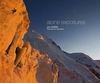
Alpine Countries Motorcycle Atlas

The alpine regions of Europe presented by Switzerland’s leading cartographic publisher Hallwag as a set of 71 handy size, waterproof and tear-resistant road maps at 1:275, 000, each with a list of biker-friendly accommodation and bike repair workshops, plus a separate index booklet which also provides a multilingual motorbike-related phrasebook. Each separate map, folded to 17x28cm, opens up to 34x28cm to cover an area of approximately 89x77km The maps present the road network graded from motorways to small local roads, indicating toll roads, roads closed to motorized traffic or subject to seasonal closures, steep gradients, etc. Scenic roads and viewpoints are highlighted. Topography is indicted by effective but unobtrusive relief shading, with plenty of names of mountain
ranges, valley, peaks, passes, etc. The maps also highlight numerous places of interest. On the reverse each sheet has a list of addresses and phone numbers of biker-friendly accommodation including campsites, plus a list of repair workshops.Multilingual map legend and the index are in a separate 62-page booklet which also includes a motorbike-related phrasebook for 18 European languages. The whole set is presented in a zip-up plastic cover.
RIP - This product is no longer available on our network. It was last seen on 25.09.2019

This page now acts as a permanent archive for this product. Add more information using the comments box below to ensure it can still be found by future generations.

Use our search facility to see if it is available from an alternative contributor.
  • External links may include paid for promotion
  • Availability: Out Of Stock
  • Supplier: Stanfords
  • SKU: 9783828307902
Availability: In Stock
£29.99

Product Description

The alpine regions of Europe presented by Switzerland’s leading cartographic publisher Hallwag as a set of 71 handy size, waterproof & tear-resistant road maps at 1:275, 000, each with a list of biker-friendly accommodation & bike repair workshops, plus a separate index booklet which also provides a multilingual motorbike-related phrasebook. Each separate map, folded to 17x 28cm, opens up to 34x 28cm to cover an area of Approx. 89x 77km The maps present the road network graded from motorways to small local roads, indicating toll roads, roads closed to motorized traffic or subject to seasonal closures, steep gradients, etc. Scenic roads & viewpoints are highlighted. Topography is indicted by effective but unobtrusive relief shading, with plenty of names of mountain ranges, valley, peaks, passes, etc. The maps also highlight numerous places of interest. On the reverse each sheet has a list of addresses & phone numbers of biker-friendly accommodation including campsites, plus a list of repair workshops. Multilingual map legend & the index are in a separate 62-page booklet which also

Includes::
a motorbike-related phrasebook for 18 European languages. The whole set is presented in a zip-up plastic cover.

Reviews/Comments

Add New

Intelligent Comparison

Oooops!
We couldn't find anything!
Perhaps this product's unique.... Or perhaps we are still looking for comparisons!
Click to bump this page and we'll hurry up.

Price History

Vouchers

No voucher codes found.
Do you know a voucher code for this product or supplier? Add it to Insights for others to use.

Facebook

Jargon Buster

ZIP - A device (Usualy Metal) used for temporarily attaching two pieces of fabric together
Plastic - A generic term for a synthetic product used in the manufacture of products
phone - Short for telephone. A device that transmits sound allowing point to point communication over long distances
switzerland - A landlocked country in western Europe. One of the richest countries in the world
Waterproof - Resistant to water, usualy specified by depth in metres
Set - a group of items usually related to one another. Some objects cannot function without the complete set of items.
Size - is the measurement of how big an object is in space.
Network - A link and communication between things. Often computers or people.
Small - something that takes up less space than normal.
Road - a manmade lane or a path that is used to speed up travel.
Zip - A Fastening which can open and close to get inside.
Resistant - Something that can repel against something.
Accommodation - A room in which someone can live in, for example in a hotel

Supplier Information

Stanfords
Stanfords was established in 1853 and opened their iconic Covent Garden flagship store in 1901. They have become the top retailer of maps, travel books and accessories in the UK and arguably offer the largest selection of maps and travel books worldwide. Famous names such as Captain Robert Falcon Scott, Ranulph Fiennes and Michael Palin have purchased from Stanfords. They now have a shop in Bristol and both stores together with other venues operate a calendar of events including talks, book signings and exhibitions. As a specialist map retailer, the map selection is comprehensive and includes road maps, street maps and walking maps from worldwide destinations, as well as a selection of world atlases and wall maps. Books include travel guides and travel literature. Stanfords also stock globes, from miniatures made of blue marble to magnificent floor-standing globes. The website features a selection of interesting articles on travel topics.
Page Updated: 2023-11-12 20:15:36

Community Generated Product Tags

Oh No! The productWIKI community hasn't generated any tags for this product yet!
Menu