
 United Kingdom
 France
 Germany
 Netherlands
 Sweden
 USA
USA
 Italy
Italy
 Spain
Spain
More From Contributor


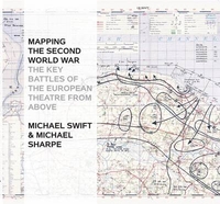
Mapping The Second World War: The Key Battles Of The European Theatre
From Above
The Second World War was a watershed in world history: the seizing of power by Hitler and the Nazis, the slowly building crescendo of annexations that led to Blitzkrieg, the conquest of Europe, the U-boat war, the strategic bombing campaign, the invasion of Russia, Stalingrad and D-Day, and the long German retreat to unconditional surrender. Mapping the Second World War does not try to retell every point in the story of the war in Europe, rather it seeks to provide - through contemporary documents - a different view of the war and suggest avenues for further research. Presenting over 100 maps it looks both at the broad sweep of events - such as the invasion of Europe in June 1944 - and at details - the two-man X-craft attack on the battleship Tirpitz - to provide a fascinating
sample of how events during the war were mapped out. Charts and maps were vital to the conduct of the war: before each military event there was planning, the reconnaissance, the conjecture as to enemy dispositions: after the event there would be debriefing, analysis of success and failure, and a redrawing of maps to show new troop positions and boundaries.Many of the maps selected have been used in actual combat and are marked up accordingly. Such battlefield annotations add to this fascinating overview of some of the key events in the Second World War and are referenced in the extended accompanying map captions. The volume is complete with a detailed narrative introduction to the progress of the war.
sample of how events during the war were mapped out. Charts and maps were vital to the conduct of the war: before each military event there was planning, the reconnaissance, the conjecture as to enemy dispositions: after the event there would be debriefing, analysis of success and failure, and a redrawing of maps to show new troop positions and boundaries.Many of the maps selected have been used in actual combat and are marked up accordingly. Such battlefield annotations add to this fascinating overview of some of the key events in the Second World War and are referenced in the extended accompanying map captions. The volume is complete with a detailed narrative introduction to the progress of the war.

Product Description
Reviews/Comments
Add New
Vouchers
No voucher codes found.
Do you know a voucher code for this product or supplier? Add it to Insights for others to use.
Do you know a voucher code for this product or supplier? Add it to Insights for others to use.
 Denmark