More From Contributor
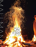
£14.99
Waterproof & tear-resistant OS Active version of map No. 40 from the Ordnance Survey’s Landranger series at 1:50, 000, with contoured & GPS compatible topographic mapping plus tourist information.MOBILE DOWNLOADS: As well as the physical edition of the map, each Landranger title now

Includes::
a code for downloading after purchase its digital version onto your smartphone or tablet for viewing on the OS smartphone app.OS LANDRANGER SERIES: to see the list of all the titles in the OS Landranger series, both paper & waterproof versions, please click on the series link. Maps in the Landranger series provide plenty of recreational & tourist information, indicating the traditional public right of way paths (except in Scotland where different laws apply), including bridleways & byways restricted or open to motorized traffic. National Trails & selected other long-distance paths are marked, as well as on-road & traffic-free cycle routes with their National/ Regional Cycle Network numbers. National Trust/ National Trust for Scotland & Forestry Commission land is clearly marked, indicating open or restricted access. A range of symbols highlights camping & caravanning sites, youth hostels, tourist information offices & visitors’ centres, parking & picnicking places, World Heritage sites, sport & recreational facilities, etc. The maps provide detailed presentation of topography with contours at 10m intervals, numerous spot heights & additional colouring and/or graphics for different types of woodlands, orchards or parkl&, rock features including scree & cliffs, water features inland & along the sea shore with marshl&, dunes, s&, mud, shingle & the high water mark. All the standard information expected of survey mapping at this scale is included: finely graded road network, railway lines with stations, cuttings, embankments, etc; individual isolated buildings; archaeological & historical sites, etc. For GPS users the British National Grid is shown at 1km intervals, with latitude & longitude given by margin ticks at 1` & cross hairs on the map at 5`. Each map covers an area of 40 x 40km, (approx. 25 x 25 miles).

...
Archived Product
£8.99
Paper version of map No. 40 from the Ordnance Survey’s Landranger series at 1:50, 000, with contoured & GPS compatible topographic mapping plus tourist information.MOBILE DOWNLOADS: As well as the physical edition of the map, each Landranger title now

Includes::
a code for downloading after purchase its digital version onto your smartphone or tablet for viewing on the OS smartphone app.OS LANDRANGER SERIES: to see the list of all the titles in the OS Landranger series, both paper & waterproof versions, please click on the series link. Maps in the Landranger series provide plenty of recreational & tourist information, indicating the traditional public right of way paths (except in Scotland where different laws apply), including bridleways & byways restricted or open to motorized traffic. National Trails & selected other long-distance paths are marked, as well as on-road & traffic-free cycle routes with their National/ Regional Cycle Network numbers. National Trust/ National Trust for Scotland & Forestry Commission land is clearly marked, indicating open or restricted access. A range of symbols highlights camping & caravanning sites, youth hostels, tourist information offices & visitors’ centres, parking & picnicking places, World Heritage sites, sport & recreational facilities, etc. The maps provide detailed presentation of topography with contours at 10m intervals, numerous spot heights & additional colouring and/or graphics for different types of woodlands, orchards or parkl&, rock features including scree & cliffs, water features inland & along the sea shore with marshl&, dunes, s&, mud, shingle & the high water mark. All the standard information expected of survey mapping at this scale is included: finely graded road network, railway lines with stations, cuttings, embankments, etc; individual isolated buildings; archaeological & historical sites, etc. For GPS users the British National Grid is shown at 1km intervals, with latitude & longitude given by margin ticks at 1` & cross hairs on the map at 5`. Each map covers an area of 40 x 40km, (approx. 25 x 25 miles).

...
Archived Product
£9.99
Mallakastra Prefecture at 1:60, 000 in a series of handy size, waterproof & tear-resistant, contoured & GPS compatible road maps from the Tirana-based publishers Vektor. Landscape is presented by altitude colouring & contours lines at 100m intervals, with spot heights & a few more names of topographic features than found on Vektor’s 200K road maps of the country. National parks & nature reserves are prominently highlighted. The prefecture maps appear to show the same small local dirt roads as in the 200K series, but given the increase in scale do so with greater clarity & also provide more detailed GPS coordinates (latitude & longitude lines are drawn at 5’ intervals), useful when travelling across the more remote parts of the country. Railway lines are included & local airports are marked. Symbols highlight campsites, beaches, archaeological & historical sites, caves, etc. The maps also show subdivisions of prefectures & names of the communes, & indicate administrative status of towns. Map legend

Includes::
English. Please note: border crossings are prominently marked but beyond topographic colouring no road or other information is provided outside the country’s borders.

...
Archived Product
£12.99
` It ought to be a film, of course, pitched somewhere between The Right Stuff & Chariots of Fire. Meanwhile, Don Hale`s well-ordered, compelling book will do nicely` Andrew Martin, Daily Express Seventy years ago, on 3 July 1938, on the East Coast main line, the streamlined A4 Pacific locomotive Mallard reached a top speed of 126mph
- a world record for steam locomotives which still stands. Since then, millions have seen this famous locomotive, resplendent in her blue livery, on display at the National Railway Museum in York. Reissued for the 75th anniversary of the speed record, Don Hale tells the full story of how the record was broken, from the nineteenth century rivalry to be fastest between London & Scotl&, &, surprisingly, traces Mallard`s futuristic design to the Bugatti car & Germany`s nascent Third Reich, which elevated the train into an instrument of national prestige. & he celebrates the singular figure of Mallard`s designer, Sir Nigel Gresley, one of Britain`s most gifted engineers. Mallard is a wonderfully nostalgic evocation of one of British technology`s finest hours. Don Hale is the author of Town without Pity, about his investigation of the wrongful conviction of Stephen Downing for murder, for which Hale was awarded the OBE.
...
Archived Product
£11.50
Mallersdorf-Pfaffenberg in a series of GPS compatible recreational editions of the Bavarian topographic survey at 1:25, 000, with waymarked hiking trails & cycling routes, campsites & youth hostels, etc. Coverage

Includes::
Ergoldsbach, Laberweinting, Neufahrn i.NB, Schierling. Contours used in this map vary between 5 to 20m according to the terrain, with 20m interval predominantly used for hilly areas. Varied colouring show different types of landscape: woods, vineyards, fields etc. Maps in this series feature extensive overprint highlighting local & long-distance footpaths & cycle routes, including King Ludwig Way or different variants of the Way of St James, indicating their waymarking. Symbols highlight different types of accommodation (campsites, youth hostels, refuges, etc), sport & recreational facilities, various places of interest, etc. The maps have a 1-km UTM grid. Map legend & all the text are in German only. To see other titles in this series please click on the series link.

...
Archived Product
£10.39
Mallorca in the Countries & Regions series from Lonely Planet, market-leading comprehensive guides aimed at independent travellers & serving a large range of international destinations. Frank & informal in style, the guides explore an extensive range of sights, activities, accommodation, restaurants & nightlife & are designed for practical use while travelling on the road. Written & researched by a team of experts, each book is independent in its recommendations & suggestions, often offering individual takes on individual destinations. Widely recognised for their reliability, each Lonely Planet country & region guide has the same layout. Introductory sections profile the destination with individual chapters on particular highlights, getting started, (including when to go) itineraries, history, culture, arts, food & drink & the environment. Each guide is organised geographically by region, with individual sections detailing an extensive range of sights, places of interest, attractions, restaurants, nightlife, accommodation & any local activities. The guides have detailed explanations of historical context where relevant. There is also practical guidance on ...
Archived Product
£12.99
Mallorca is the Sunflower Landscapes guide to exploring the best walking & touring possibilities on the isl&. The guide covers a range of routes including walks in Sant Elm, Galatzo, Santa Eugenia, Cuber Lake & the Es Barranc circuit. A double-sided, fold-out touring map of Mallorca gives an overview of the island & the locations of each walk. Detailed information about touring by hired car or public transport, as well as on foot, is provided, helping walkers to navigate & plan day-trips. Shorter strolls are also included as an alternative for each main route for those seeking more leisurely days out. The guide is structured in two main parts ...
Archived Product
£12.99
Take the trouble out of travel with AA Key Guides. For independent travellers wishing to select the best for their holiday, the series now covers Mallorca. Helping you make the right choice, the guide contains super clear mapping, colour photographs & information you really need. There are floor plans throughout & each sight is marked on maps & presented with grid references for easy location. Expert advice is given on the very best things to see & do plus recommended places to eat & stay at all price levels. With coloured plastic dividers uniquely separating each section, Key Guides really are the easiest to use guides...ever! ...
Archived Product
£24.95
The Mediterranean island of Mallorca is now well-known as a sport climbing destination. Since the last Rockfax in 2006, it has also established itself as the home of Europe`s best deep water soloing. This latest edition of the ” Mallorca Rockfax” (our 6th Mallorca publication in 15 years!) brings together all the sport & DWS into one book. The sport section

Includes::
seven crags that haven`t appeared in our previous books, & the DWS section combines the work from the Rockfax book Deep Water, & the Rockfax PDF Mini Guide Mallorca Deep Water Soloing. The style is in the new glorious full-colour format & features many new crag & action photos. ” The Mallorca Rockfax” is the essential companion to your holiday visit to this wonderful isl&. The Mediterranean island of Mallorca is now well-known as a sport climbing destination. Since the last Rockfax in 2006, it has also established itself as the home of Europe`s best deep water soloing. This latest edition of the ” Mallorca Rockfax” (our 6th Mallorca publication in 15 years!) brings together all the sport & DWS into one book. The sport section

Includes::
seven crags that haven`t appeared in our previous books plus many new routes & sectors at the existing crags, & the DWS section combines the work from the Rockfax book Deep Water, & the Rockfax PDF Mini Guide Mallorca Deep Water Soloing. Rockfax is now the default guide for Mallorca. This will be the only English language guidebook that covers this wide range of crags & the only book that is easily available to travelling climbers. It will also be the only guidebook in print for several of the crags. Sport Climbing covers
- Puig de Garrafa, Santa Ponca, Sa Cantera, La Valle Verde, Galilea, Can Ortigues, S`estret, Es Verger, Valldemossa, Sa Gubia, Fraguel, Port de Soller, C`an Nyic, Gorge Blau, Es Queixal, Alaro, Les Perxes, La Creveta, El Fumat, Xon Xanquete, El Calo de Betlem, Ermita de Betlem, Puig St. Marti, Son Servera, Sa Mola de Felantix, Felanitx, Cala Magraner, Tijuana Deep Water Soloing
- Cova del Diablo, Porto Cristo, Porto Cristo Novo, Cala Barques, Porto Colom, Cala Marcal, Cala Sa Nau, Cala Mitjana, Cala Serena, Santanyi, Cala Llombards, Sa Calobra, & Porto Pi.


...
Archived Product
£10.39
Mallorca & Menorca in the Countries, Regions & Cities series from Rough Guides; comprehensively detailed guidebooks specifically designed for independent travellers & serving a range of worldwide destinations. Widely recognised for their free editorial style, Rough Guide authors are allowed to express their personal opinions on a range of subjects. Although sometimes controversial, this editorial stance allows readers to experience more detailed & personal takes on each destination, a feature often more limited in other guidebooks. Cultural & historical nuances are explored in significant depth throughout the text & descriptions on the ambience of individual settings alongside personal recommendations, particularly in cities, are notably prevalent. Each Rough Guide in the Countries, Regions & Cities series has a similar layout. A ...
Archived Product

Mallmann On Fire

”Elemental, fundamental, and delicious” is how Anthony Bourdain describes the trailblazing live-fire cooking of Francis Mallmann. The New York Times called Mallmann`s first book, Seven Fires, ”captivating” and ”inspiring.” And now, in Mallmann on Fire, the passionate master of the Argentine grill takes us grilling in magical places - in winter`s snow, on mountaintops, on the beach, on the crowded streets of Manhattan, on a deserted island in Patagonia, in Paris, Brooklyn, Bolinas, Brazil - each locale inspiring new discoveries as revealed in 100 recipes for meals both intimate and outsized. We encounter legs of lamb and chicken hung from strings, coal-roasted delicata squash, roasted herbs, a parrillada of many fish, and all sorts of griddled and charred
meats, vegetables, and fruits, plus rustic desserts cooked on the chapa and baked in wood-fired ovens. At every stop along the way there is something delicious to eat and a lesson to be learned about slowing down and enjoying the process, not just the result.
RIP - This product is no longer available on our network. It was last seen on 25.09.2019

This page now acts as a permanent archive for this product. Add more information using the comments box below to ensure it can still be found by future generations.

Use our search facility to see if it is available from an alternative contributor.
  • External links may include paid for promotion
  • Availability: Out Of Stock
  • Supplier: Stanfords
  • SKU: 9781579655372
Availability: In Stock
£27.99

Product Description

” Elemental, fundamental, & delicious” is how Anthony Bourdain describes the trailblazing live-fire cooking of Francis Mallmann. The New York Times called Mallmann`s first book, Seven Fires, ”captivating” & ”inspiring.” & now, in Mallmann on Fire, the passionate master of the Argentine grill takes us grilling in magical places
- in winter`s snow, on mountaintops, on the beach, on the crowded streets of Manhattan, on a deserted island in Patagonia, in Paris, Brooklyn, Bolinas, Brazil
- each locale inspiring new discoveries as revealed in 100 recipes for meals both intimate & outsized. We encounter legs of lamb & chicken hung from strings, coal-roasted delicata squash, roasted herbs, a parrillada of many fish, & all sorts of griddled & charred meats, vegetables, & fruits, plus rustic desserts cooked on the chapa & baked in wood-fired ovens. At every stop along the way there is something delicious to eat & a lesson to be learned about slowing down & enjoying the process, not just the result.

Reviews/Comments

Add New

Intelligent Comparison

Oooops!
We couldn't find anything!
Perhaps this product's unique.... Or perhaps we are still looking for comparisons!
Click to bump this page and we'll hurry up.

Price History

Vouchers

No voucher codes found.
Do you know a voucher code for this product or supplier? Add it to Insights for others to use.

Facebook

Jargon Buster

New York - A United States State. Commonly known as the Big Apple
Beach - An area on the coast consisting of a sandy or pebbled area
Brazil - A country in South America
Rustic - An obect which has not been finely finished leaving a natural finish, often unique
Wood - A hard material found in trees. Used for tool making, fuel and construction.
Fire - the release of energy through heat and light.
Fish - A creature that lives in water. A fish uses gills to breath unlike mammals
Snow - Water and vapour in clouds that falls in a white crystal form leaving a white layer.
Winter - The fourth season of a year that comes between Spring and Autumn

Supplier Information

Stanfords
Stanfords was established in 1853 and opened their iconic Covent Garden flagship store in 1901. They have become the top retailer of maps, travel books and accessories in the UK and arguably offer the largest selection of maps and travel books worldwide. Famous names such as Captain Robert Falcon Scott, Ranulph Fiennes and Michael Palin have purchased from Stanfords. They now have a shop in Bristol and both stores together with other venues operate a calendar of events including talks, book signings and exhibitions. As a specialist map retailer, the map selection is comprehensive and includes road maps, street maps and walking maps from worldwide destinations, as well as a selection of world atlases and wall maps. Books include travel guides and travel literature. Stanfords also stock globes, from miniatures made of blue marble to magnificent floor-standing globes. The website features a selection of interesting articles on travel topics.
Page Updated: 2023-11-12 20:15:36

Community Generated Product Tags

Oh No! The productWIKI community hasn't generated any tags for this product yet!
Menu