More From Contributor
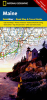
£17.99
Enjoy the best of hotels & restaurants in Europe, with MICHELIN Main cities of Europe. Over 3000 hotels & restaurants have been selected for the constant quality of their services. MICHELIN Guide Europe caters for individual tastes & budgets: from Bib Gourmand for an affordable & enjoyable meal & starred restaurants for special occasions in 44 cities across 20 different countries... You can also choose a hotel in all confidence from cosy guesthouses to luxury hotels. The MICHELIN red Guide to Europe will open your appetite with its short & inviting description for each venue illustrated with colour photographs. To add to your Michelin experience, you will also find a lively introduction to big cities & information on tourist sights & attractions. ...
Archived Product
£740.00
Imagine being at sea in a large freighter in the early 20th century. In the 20`s you might have found a similar lamp in large stairwells, aircraft hangers & factories or the cargo hold in a ship. Use as a room light, a shop lamp over the table, dinning room table lamp
- or use to light your cargo hold. Featuring a polished aluminum with stainless steel exterior, the authentic Models Main Hold pendant lamp is an addition that is sure to put a unique spin on your home decor. Perfect for a classic or modern interior, this lamp is sure to draw the eye. Compatible with a 100-watt incandescent or 23-watt CFL bulb.

Includes::
a ceiling bracket. If we do not have this item in stock we will order it for you from our supplier. Delivery generally takes 3 weeks within the UK. For overseas delivery queries please email sales@stanfords.co.uk


...
Archived Product
£5.95
One of the titles in a series of small, double-sided maps showing each route in sections. An overprint highlights the route, indicating sections shared with motorized traffic, intermediate distances, & stretches with poor road surface, as well as recommended overnight stops, campsites, youth hostels, & sites worth visiting. The maps include street plans of selected towns & descriptions, in German only, of the main places of interest along the route. The maps have no geographical coordinates. Map legend is in German only. Most titles come with a separate small booklet giving addresses & telephone numbers of tourist information centres, cycle repair facilities, & accommodation. Only the titles listed here are still available from the initial much longer list published by Kompass.. ...
Archived Product
£17.50
The Main River Cycle Route, a 520-km long cycle route from Bayreuth across the beautiful cities of Bamberg & Würzburg, to Frankfurt & Mainz
- ideal relaxation after the Rings, Tristans or Parsifals, presented by the Verlag Esterbauer in a guide with maps at 1:75, 000 showing the route & its variants. Extensive information is conveyed by symbols, indicating road surface, campsites & other accommodation, repair workshops, recreational facilities, places of interest, etc. A list of various types of accommodation facilities is included.IMPORTANT
- PLEASE NOTE BEFORE ORDERING
- ALL THE TEXT IN THIS TITLE IS GERMAN ONLY. MAP LEGEND

Includes::
ENGLISH (please see our sample image) & the information provided on the maps is sufficient to use this title without any knowledge of German.ABOUT THE BIKELINE SERIES: all the titles have been meticulously researched & are highly regarded in their native Germany. Most titles, as indicated in their individual descriptions, also include a separate section listing selected accommodation, from hotels to campsites, youth hostels & rooms in private houses, all with addresses, telephone numbers & price range. Information on towns along each route

Includes::
a list of places of interest, with opening hours, etc. Several of the guides also have street plans. To see the list of other titles in the Bikeline series please click on the series link.


...
Archived Product
£11.50
Mainburg in a series of GPS compatible recreational editions of the Bavarian topographic survey at 1:25, 000, with waymarked hiking trails & cycling routes, campsites & youth hostels, etc. Coverage

Includes::
Nandlstadt, Rudelzhausen, Au i.d. Hallertau, Attenkirchen, Wolnzach, Hörgertshausen. Contours used in this map vary between 5 to 20m according to the terrain, with 20m interval predominantly used for hilly areas. Varied colouring show different types of landscape: woods, vineyards, fields etc. Maps in this series feature extensive overprint highlighting local & long-distance footpaths & cycle routes, including King Ludwig Way or different variants of the Way of St James, indicating their waymarking. Symbols highlight different types of accommodation (campsites, youth hostels, refuges, etc), sport & recreational facilities, various places of interest, etc. The maps have a 1-km UTM grid. Map legend & all the text are in German only. To see other titles in this series please click on the series link.

...
Archived Product
£6.99
Maine in a series of US state maps from the National Geographic with cartography from Mapquest, including city maps of Portland with an enlargement for the downtown area, Bangor, Lewiston
- Auburn, Augusta, Freeport
- Yarmouth & Bar Harbour, an enlargement for the Acadia National Park, plus a scenic drive route along the coast from Kittery to Lubec overlooking more than 60 lighthouses. The map is printed on lightweight, waterproof & tear-resistant plastic paper. Maps in the NGS State Series clearly show each state’s national parks, forests & other protected areas, with topography indicated by subtle relief shading & plenty of names of mountain ranges, valleys, deserts, etc. Indian Reservations are also marked & various places of interest are highlighted, including historical or natural sites, visitor information centres, campsites, etc. Road network indicates toll roads, rest areas & services, & shows driving distances on main routes. Scenic roads are highlighted. The maps have no geographical coordinates. The index lists both counties, shown on the maps with their administrative boundaries, & towns or cities. Each title

Includes::
several enlargements showing in greater detail local towns, national parks & other popular destination, all annotated with places of interest. Also provided are general notes about the state with descriptions of its main sights, a recommendation for a scenic drive, a table of services available in the local sites (both national parks & historical monuments), a calendar of local special events, a distance table & a climate chart.


...
Archived Product
£3.99
Maine Biking in the Moon Spotlight guide series; covering a range of specific local cities, districts, areas & regions in North, Central & South America & targeted at those seeking to travel to a specific area within a country. Each of the guides has been extracted in full from the relevant country Moon Handbook & individual titles focus on a particular city, region or notable area of the destination. Many of the guides in the series are unique in their coverage, although are limited in putting the destination into its wider geographical context that a more comprehensive guide would provide. Stylistically, Moon ...
Archived Product
£8.99
Maine in the Frommer`s Day By Day series is a pocket-sized guide ideal for short trips, covering a variety of budgets. The best sights of each destination are listed in convenient full-day tours for one, two or three days such as: thematic tours for interests including art, architecture & history are described, allowing you to get the most out of your time; walking tours take you around each destination’s principal neighbourhoods, detailing selected parks, activities, notable sights, shops & eateries. Categorized listings are given for the best of the area’s hotels & accommodation, shopping, food & drink, nightlife, music, outdoor activities, day-trips, & arts & entertainment, whilst a “ Savvy Traveller” section provides practical travel information, as well as a brief background & history of the destination. The guide is illustrated with colour photography & simple, easy-to-use bulleted maps with locations cross-referenced to the text, as well as having a removable tear-proof folded map in a pouch inside the back cover. ...
Archived Product
£9.99
Maine on a laminated & waterproof Easy-to-Fold map from Rand Mc Nally, the country’s leading publisher of road maps & street plans. For clarity of road information Rand Mc Nally state maps present the road network on a plain background, with no or little topographic detail. Driving distances are indicated on all principal highways & on many local routes. National or state parks & other protected areas, Indian Reservations & restricted entry military zones are highlighted & symbols indicate campsites, rest areas, various places of interest, etc. Each map shows local administrative boundaries with names of the counties, is indexed & gives geographical coordinates as margin ticks usually at 1° intervals. Rand Mc Nally state maps are available in two formats: double-sided Easy-to-Read maps with numerous enlargements for cities and/or most visited areas, & laminated Easy-to-Fold maps in a more handy format but with smaller print. TO SEE THE LIST OF RAND Mc NALLY STATE MAPS PLEASE CLICK ON THE SERIES LINK. ...
Archived Product
£6.99
Maine Easy-to-Read map from Rand Mc Nally, US leading publisher of road maps & street plans, in their extensive series of state maps. Additional panels provide enlargements for: Acadia National Park, Augusta, Bangor, Brunswick
- Bath, Kittery
- Portsmouth NH, Lewiston
- Auburn, Portland & Saco
- Biddleford. For clarity of road information Rand Mc Nally state maps present the road network on a plain background, with no or little topographic detail. Driving distances are indicated on all principal highways & on many local routes. National or state parks & other protected areas, Indian Reservations & restricted entry military zones are highlighted & symbols indicate campsites, rest areas, various places of interest, etc. Each map shows local administrative boundaries with names of the counties, is indexed & gives geographical coordinates as margin ticks usually at 1° intervals. Rand Mc Nally state maps are available in two formats: double-sided Easy-to-Read maps with numerous enlargements for cities and/or most visited areas, & laminated Easy-to-Fold maps in a more handy format but with smaller print. TO SEE THE LIST OF RAND Mc NALLY STATE MAPS PLEASE CLICK ON THE SERIES LINK.


...
Archived Product

Maine

Maine in a series of US state maps from the National Geographic with cartography from Mapquest, including city maps of Portland with an enlargement for the downtown area, Bangor, Lewiston - Auburn, Augusta, Freeport - Yarmouth and Bar Harbour, an enlargement for the Acadia National Park, plus a scenic drive route along the coast from Kittery to Lubec overlooking more than 60 lighthouses. The map is laminated and waterproof.Maps in the NGS State Series clearly show each state
RIP - This product is no longer available on our network. It was last seen on 25.09.2019

This page now acts as a permanent archive for this product. Add more information using the comments box below to ensure it can still be found by future generations.

Use our search facility to see if it is available from an alternative contributor.
  • External links may include paid for promotion
  • Availability: Out Of Stock
  • Supplier: Stanfords
  • SKU: 9780792235934
Availability: In Stock
£8.50

Product Description

Maine in a series of US state maps from the National Geographic with cartography from Mapquest, including city maps of Portland with an enlargement for the downtown area, Bangor, Lewiston
- Auburn, Augusta, Freeport
- Yarmouth & Bar Harbour, an enlargement for the Acadia National Park, plus a scenic drive route along the coast from Kittery to Lubec overlooking more than 60 lighthouses. The map is laminated & waterproof. Maps in the NGS State Series clearly show each state

Reviews/Comments

Add New

Price History

Vouchers

No voucher codes found.
Do you know a voucher code for this product or supplier? Add it to Insights for others to use.

Facebook

Jargon Buster

Waterproof - Resistant to water, usualy specified by depth in metres
Laminated - A thin layer of plastic that gives a coating and shine to a material.

Supplier Information

Stanfords
Stanfords was established in 1853 and opened their iconic Covent Garden flagship store in 1901. They have become the top retailer of maps, travel books and accessories in the UK and arguably offer the largest selection of maps and travel books worldwide. Famous names such as Captain Robert Falcon Scott, Ranulph Fiennes and Michael Palin have purchased from Stanfords. They now have a shop in Bristol and both stores together with other venues operate a calendar of events including talks, book signings and exhibitions. As a specialist map retailer, the map selection is comprehensive and includes road maps, street maps and walking maps from worldwide destinations, as well as a selection of world atlases and wall maps. Books include travel guides and travel literature. Stanfords also stock globes, from miniatures made of blue marble to magnificent floor-standing globes. The website features a selection of interesting articles on travel topics.
Page Updated: 2023-11-12 20:15:36

Community Generated Product Tags

Oh No! The productWIKI community hasn't generated any tags for this product yet!
Menu