
 United Kingdom
 France
 Germany
 Netherlands
 Sweden
 USA
USA
 Italy
Italy
 Spain
Spain
More From Contributor


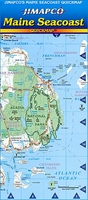
Maine Seacoast Quickmap
The seacoast of Maine shown in three sections on a double-sided, indexed, laminated map from Jimapco at 1:270, 000, with seven insets providing enlargements to show the most popular areas in greater detail. The coastline is presented on three larger panels at 1:270, 000, indicating which areas are presented in greater detail on the surrounding enlargements. The map clearly shows road numbers and includes local country roads. Colouring indicates urban areas and highlights national and state parks/forests and other protected areas. Symbols mark various places of interest including campsites, wineries, golf sources, etc. The map is indeed for communities and places of interest.

Product Description
Reviews/Comments
Add New
Vouchers
No voucher codes found.
Do you know a voucher code for this product or supplier? Add it to Insights for others to use.
Do you know a voucher code for this product or supplier? Add it to Insights for others to use.
 Denmark