More From Contributor
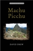
£7.95
Macerata Province in a series of handy size road maps from Litografia Artistica Cartografica (LAC) with more minor local roads & tracks than can be found on most regional maps. The series is gradually being changed to a new style of digitally derived cartography, so presentation of adjoining titles may vary. All the maps have hill shading to represent the general relief with spot heights for selected peaks, & show a few more local roads & rough tracks than the other road map series. Intermediate road distances are indicated. Regional, provincial & communal borders are marked, & railways, funiculars, airports, sea ferry links & campsites are shown. The legend is in Italian only. The new, digitally produced editions are indexed & have enhanced, more finely drawn cartography: the hill-shading is less bold, motorway service areas are marked, natural parks are highlighted & an expanded range of symbols indicates various landmarks & sites, e.g. antiquities, churches, etc. Two styles of the new cartography are produced, differing only in the colour of the predominant background shading: grey or yellow/green. Some of the new editions include geographical coordinates for the map corners. The index of localities is on the reverse. This title is still produced in the traditional cartographic style. ...
Archived Product
£10.95
Macgillycuddy's Reeks at 1:30, 000 on a waterproof & tear-resistant, GPS compatible map from Harvey Map Services in their Superwalker series covering popular hiking areas of Great Britain & Irel&, annotated with additional information for walkers. The maps have contours at 15m intervals, with additional graphics for various types of terrain (crags, large boulders, scattered rocks) & colouring for different kinds of land use or vegetation (pastures, bogs, forests or woodl&, etc). The maps show local hiking paths, indicating, where appropriate, long-distance routes & boundaries of national parks or other protected areas. Scottish titles also indicate Munro, Corbett & Graham hills. Some maps in addition highlight local cycle routes.A range of symbols mark various facilities for walkers including youth or independent hostels, campsites & caravan sites, information points, etc. Each map has a 1-km with British or Irish national grid. ...
Archived Product
£12.50
Macgillycuddy`s Reeks & the Killarney National Park on a double-sided, GPS compatible map at 1:25, 000 from the Ordnance Survey Ireland with cartography of the country’s topographic survey, plus the central part of the Reeks at 1:12, 500. Coverage extends from Killarney westwards to Lough Caragh. Where appropriate place names are given in both Irish & English versions. Topography is vividly presented by contours at 10m intervals with additional graphics and/or colouring to show bogs, moraine, scree, different types of woodlands, etc. Waymarked hiking paths & their trailheads are highlighted, & the map also shows the Ring of Kerry cycle route. Symbols indicate camping & caravan sites, youth hostels, locarions for horse riding or angling, information offices, bus stops, etc. The map has a 1km ITM (Irish Transverse Mercator) grid, plus latitude & longitude margin ticks at 1’. An enlargement presents the central part of the Macgillycuddy’s Reeks, around Carrauntoohil & Lough Callee in greater detail & clarity at 1:12, 500. ...
Archived Product
£12.95
Cairn Gorm & Ben Avon area in the heart of the Scottish Highlands at 1:25, 000 on a waterproof & tear-resistant map from Harvey Map Services in their Superwalker series. The peak of Cairn Gorm is on the eastern side of the map, with coverage extending north to Glanmore & the outskirts of Aviemore, west to Achlean & River Feshie & south to the Glenfeshire Forest & Sgòr Mòr.PLEASE NOTE: this title is also available as a pocket-size Ultramap with its scale reduced to 1:40, 000
- to see the list of titles available in this series please click on the series link. Maps in Harvey’s Superwalker series have contours at 15m intervals, with additional graphics for various types of terrain (crags, large boulders, scattered rocks) & colouring for different kinds of land use or vegetation (pastures, bogs, forests or woodl&, etc). The maps show local hiking paths, indicating where appropriate long-distance routes, & boundaries of national parks or other protected areas. Scottish titles also indicate Munro, Corbett & Graham hills. Some maps in addition highlight local cycle routes. A range of symbols mark various facilities for walkers including youth or independent hostels, campsites & caravan sites, information points, etc. Each map has a 1-km British or Irish national grid.
...
Archived Product
£17.99
Topographic survey of Portugal at 1:25, 000 from the Instituto Geográfico do Exército, the country’s military survey organisation. Map legend & a glossary of terms used on the maps include English. To see all the titles in this series please click on the series link. ...
Archived Product
£15.99
This title describes the site that is voted one of the new seven wonders of the world in 2007. A hundred years ago in July 1911, Hiram Bingham discovered, or more correctly, came across, the iconic `lost city of the Incas` in the Peruvian Andes
- now threatened both by tourism & by the climate. Published for the centenary, ” Machu Picchu” tells the story of this astonishing site, & examines how interpretations of the site have been transformed over the last twenty years. Using the evidence of early Spanish documents, new archaeology &, significantly, looking at material controversially removed from Peru by Bingham, this book breaks exciting new ground on this immense subject.
...
Archived Product
£11.99
Detailed archaeological plan of Machu Picchu showing tourist routes across the site, including the summit of the Huayna Picchu, prepared by the Wright Paleohydrological Institute in Denver & published in conjunction with Peru’s Instituto Nacional de Cultura. All complexes & units are shown with their numbers. Colouring indicates principal Inca routes & corrals, as well as gardens & agricultural areas. Structural walls are shows with doorways, windows, & niches. The plan also indicates double jamb doorways, stairways, fountains, etc, plus shows the site’s drainage system. Symbols mark locations of shrines, temples, observatories, subterranean caves & points of special archaeological interest. On the reverse are photographs of notable features cross-referenced to their locations & annotated with brief descriptions. ...
Archived Product
£11.99
Travel writer Ben Westwood covers Peru`s most popular destination in ” Moon Machu Picchu.” Westwood offers his seasoned advice on can`t-miss attractions, as well as unique trip ideas, such as The 14-Day Adventure Tour. Complete with tips on shopping & dining in Cusco, getting to & from the ruins, & exploring every inch of the legendary ” Lost City of the Incas, ” ” Moon Machu Picchu” gives travelers the tools they need to create a more personal & memorable experience. This edition of ” Moon Machu Picchu” is full-color throughout. ...
Archived Product
£29.99
One of the maps in the topographic survey of Peru from the country’s national survey organization, Instituto Geográfico Nacional. Contours are at 25m intervals & colouring/symbols indicate different types of terrain & vegetation. Some of the maps may contain small blank spaces representing as yet unmapped areas. Each sheet covers 30’ latitude by 30’ longitude. The maps have a 1km UTM grid & margin ticks for latitude & longitude at intervals of 1’. Publication dates vary; most maps were published in 1960s to 1990s, with some sheets revised more recently. Map legend is in Spanish only, except in the more recent editions which also include English. ...
Archived Product
£3.50
Machynlleth in 1900 in a fascinating series of reproductions of old Ordnance Survey plans in the Alan Godfrey Editions, ideal for anyone interested in the history of their neighbourhood or family. The map covers an important mid-Wales market town, where Owain Glyndwr is said to have held his Parliament in 1404; the site of the Parliament House is shown in Maengwyn Street. Other features include the Workhouse, Plas Machynlleth, Graig-fach, Llynlloedd, stations for Cambrian & Corris Railways, St Peter`s church. The map extends about a mile east of the town, including Park Common, Dol-gau Woollen Factory, Afon Dulas, Felin-gerig Woollen Factory, old copper levels, Newlands, etc. The introduction is in Welsh & English & a brief trade directory are also included. About the Alan Godfrey Editions of the 25” OS Series: Selected towns in Great Britain & Ireland are covered by maps showing the extent of urban development in the last decades of the 19th & early 20th century. The plans have been taken from the Ordnance Survey mapping & reprinted at about 15 inches to one mile (1:4, 340). On the reverse most maps have historical notes & many also include extracts from contemporary directories. Most maps cover about one mile (1.6kms) north/south, one & a half miles (2.4kms) across; adjoining sheets can be combined to provide wider coverage.FOR MORE INFORMATION & A COMPLETE LIST OF ALL AVAILABLE TITLES PLEASE CLICK ON THE SERIES LINK. ...
Archived Product

Machu Picchu

Situated high in the Peruvian Andes, the fifteenth-century Inca palace complex at Machu Picchu is one of the most spectacular archaeological sites in the world. In this beautifully illustrated book, leading American and Peruvian scholars provide an unprecedented overview of the site, its place within the Inca empire, the mysteries surrounding its establishment and abandonment, and the discoveries made there since the excavations by archaeologist Hiram Bingham III in the early twentieth century.Drawing upon the most recent scientific findings, the authors vividly describe the royal estate in the cloud forest where the Inca emperor and his guests went to escape the pressures of the capital. In addition to Bingham`s exciting account of his first expedition in 1911, the book includes
new and archival photographs of the site as well as colour illustrations and explanations of some 120 gold, silver, ceramic, bone, and textile works recovered at Machu Picchu.It was selected by ”Choice Magazine” as an Outstanding Academic Title for 2005. It is the winner of the 2007 Philip Johnson Award of the Society of Architectural Historians.
RIP - This product is no longer available on our network. It was last seen on 25.09.2019

This page now acts as a permanent archive for this product. Add more information using the comments box below to ensure it can still be found by future generations.

Use our search facility to see if it is available from an alternative contributor.
  • External links may include paid for promotion
  • Availability: Out Of Stock
  • Supplier: Stanfords
  • SKU: 9780300136456
Availability: In Stock
£14.99

Product Description

Situated high in the Peruvian Andes, the fifteenth-century Inca palace complex at Machu Picchu is one of the most spectacular archaeological sites in the world. In this beautifully illustrated book, leading American & Peruvian scholars provide an unprecedented overview of the site, its place within the Inca empire, the mysteries surrounding its establishment & abandonment, & the discoveries made there since the excavations by archaeologist Hiram Bingham III in the early twentieth century. Drawing upon the most recent scientific findings, the authors vividly describe the royal estate in the cloud forest where the Inca emperor & his guests went to escape the pressures of the capital. In addition to Bingham`s exciting account of his first expedition in 1911, the book

Includes::
new & archival photographs of the site as well as colour illustrations & explanations of some 120 gold, silver, ceramic, bone, & textile works recovered at Machu Picchu. It was selected by ” Choice Magazine” as an Outstanding Academic Title for 2005. It is the winner of the 2007 Philip Johnson Award of the Society of Architectural Historians.

Reviews/Comments

Add New

Intelligent Comparison

Oooops!
We couldn't find anything!
Perhaps this product's unique.... Or perhaps we are still looking for comparisons!
Click to bump this page and we'll hurry up.

Price History

Vouchers

No voucher codes found.
Do you know a voucher code for this product or supplier? Add it to Insights for others to use.

Facebook

Jargon Buster

Gold - A precious highly conductive metal
Silver - A colour based on the colour of the metal
Silver - A chemical element, metalic. Has the highest elctrical conductance of any element. Also known for its exceptional anitmicrobal properties
Forest - A area with a high density of trees
Ceramic - A hard material with excellent heat resistance made by heating a crystaline substance such as clay
World - A physical grouping, commonly used to describe earth and everything associated with ti
Colour - The categorised spectrum of light visable to humans
Gold - A colour, a type of rich metal. Chemical symbol AU.
Spectacular - Something that catches that eye due to its eye catchingness.
illustrations - Pictures typically in books and newspapers.
Estate - A group of houses on the same land or area.

Supplier Information

Stanfords
Stanfords was established in 1853 and opened their iconic Covent Garden flagship store in 1901. They have become the top retailer of maps, travel books and accessories in the UK and arguably offer the largest selection of maps and travel books worldwide. Famous names such as Captain Robert Falcon Scott, Ranulph Fiennes and Michael Palin have purchased from Stanfords. They now have a shop in Bristol and both stores together with other venues operate a calendar of events including talks, book signings and exhibitions. As a specialist map retailer, the map selection is comprehensive and includes road maps, street maps and walking maps from worldwide destinations, as well as a selection of world atlases and wall maps. Books include travel guides and travel literature. Stanfords also stock globes, from miniatures made of blue marble to magnificent floor-standing globes. The website features a selection of interesting articles on travel topics.
Page Updated: 2023-11-12 20:15:36

Community Generated Product Tags

Oh No! The productWIKI community hasn't generated any tags for this product yet!
Menu