
 United Kingdom
 France
 Germany
 Netherlands
 Sweden
 USA
USA
 Italy
Italy
 Spain
Spain
More From Contributor


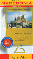
Macedonia
Indexed road map of Macedonia at 1:250, 000 from Gizi Map with a street plan of central Skopje. The map offers a vivid presentation of the country’s mountainous topography through relief shading, altitude colouring, peak heights and plenty of names of mountain ranges, plus highlighting of the national parks. Names of many towns are also shown in Cyrillic alphabet.Road network includes local roads and tracks, shows driving distances on main and many secondary routes, and indicates border crossings from the neighbouring countries. Railway lines and local airports are included. Symbols indicate locations with tourist accommodation, campsites, and other places of interest. Latitude and longitude lines are drawn at intervals of 15’. The index is next to the map. Map legend includes
English. Also provided is a street plan of central Skopje annotated with places interest.Please note: this title is also available as a wall map.
English. Also provided is a street plan of central Skopje annotated with places interest.Please note: this title is also available as a wall map.

Product Description
Reviews/Comments
Add New
Vouchers
No voucher codes found.
Do you know a voucher code for this product or supplier? Add it to Insights for others to use.
Do you know a voucher code for this product or supplier? Add it to Insights for others to use.
 Denmark