More From Contributor
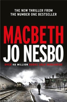
£30.00
This is a facsimile of Macauley`s Station Map of the Railways of Great Britain published in 1881 showing all the lines built & planned at that date & the owners of each line. By this date the railway network in Britain was largely complete but many changes took place between 1881 & the eve of the Grouping in 1923
- some of the planned lines were never built & many of the original owning companies were taken over by other companies. This is a portrait of Britain`s railways as the well known large companies (which ultimately came to be be narrowed down to the Big Four) were vying with a myriad of local lines to rationalise a network which had been built on the various demands of local communities & business interests throughout Britain. The book also comprises the 4th edition of Airey`s Railway Junction Diagrams which was published in 1880. This is the perfect complement to Macauley`s railway atlas as it shows in detail each contemporary railway junction in Britain where different (often competing) railway companies met on the network. The original volume of junction diagrams comprises 130 pages of maps which have been interposed in this edition with the relevant pages of the atlas.
...
Archived Product
£9.99
Young readers will love searching for Macavity, the Mystery Cat in this fun & witty lift-the-flap book, based on one of the most famous of all T. S. Eliot`s cats. Beautifully illustrated by Arthur Robins & with an appeal extending beyond Eliot fans, Macavity`s Not There! will sit alongside classic lift-the-flap books such as Where`s Spot? & Dear Zoo. ...
Archived Product
£19.99
Cute & cuddly Macaw soft toy with excellent detailing. Swing tag

Includes::
educational facts about the animal,

...
Archived Product
£12.99
Topographic survey of France at 1:25, 000 in IGN`s excellent TOP25 / Série Bleue series. All the maps are GPS compatible, with a 1km UTM grid plus latitude & longitude lines at 5’ intervals. Contours are at 5m intervals except for mountainous areas where the maps have contours at 10m intervals, vividly enhanced by hill shading & graphics for rocky terrain. Colouring with graphics indicates different types of vegetation or land use (deciduous or coniferous forests, moors, orchards, vineyards, etc). PLEASE NOTE: coverage of France at this scale is currently being revised – the format & the presentation of each title are indicated by the letters at the end of its Sheet Reference number (e.g. 0416ET, 3531ETR, 1923SB, etc.)MAPS WITH FULL TOURIST OVERPRINT & AN ENGLISH MAP LEGEND: all TOP25 maps & the SB editions of Série Bleue have an overprint highlighting waymarked walking trails including long-distance GR routes &, where appropriate, ski routes. Symbols indicate campsites, gîtes d’etape, refuges, equestrian centres & other recreational facilities or sites, tourist information centres, cultural heritage, etc. Towns & locations of particular interest are highlighted.- ET or OT = single-sided TOP25 map covering approx. 29x 21 km / 18x 13 miles.- ETR or OTR = waterproof & tear resistant TOP25 map covering the same area as the corresponding ET or OT number, but double-sided, printed on a smaller size sheet with a good overlap between the sides.- SB = Série Bleue map with full tourist overprint; these maps, first introduced in summer 2014, each cover approx. 29x 24km / 18x 15 miles.SÉRIE BLEUE maps with numbers ending in E (Est) or O (Ouest): most editions now indicate the GR routes, but do not show any other tourist information. Map legend is in French only. Each map covers approx. 14x 20km / 9x 12 miles. ...
Archived Product
£1.99
Macbeth is one of Shakespeare's four great tragedies, encompassing witchcraft, bloody murder, ghostly apparitions as well as high poetry, blended in such a way as to demonstrate the assured dramatic touch of Shakespeare's maturity. Macbeth's tragedy is that of a good, brave & honourable man turned into the personification of evil by the workings of unreasonable ambition. It was a lesson lost on King James I & VI, for whom the play was written. ...
Archived Product
£3.99
Street by Street Macclesfield Midi has been fully updated with a stylish new cover design, in a handy glovebox size. Quick to navigate & easy-to-use, the maps clearly show AA recommended restaurants, pubs, hotels, one-way streets & car parks. Featuring a clever use of colour to ensure they can be read under street lighting, & National Grid referencing, the Street by Street Macclesfield Midi map is all you need to keep you on the move. ...
Archived Product
£3.50
Macclesfield North in 1907 in a fascinating series of reproductions of old Ordnance Survey plans in the Alan Godfrey Editions, ideal for anyone interested in the history of their neighbourhood or family. The map covers the northern part of Macclesfield, stretching from Great King Street northward to Beech Hall, & from Mount Pleasant eastward to Holy Trinity church. Features include Central station, Hibel Road station, engine shed & goods shed, Lower Heys Mill, Albert Mills, Hurdsfield House, Red House Farm, St Michael`s church, Infirmary, Free Grammar School, Market Place, Town Hall, Victoria Park, Macclesfield Union Workhouse, cemetery, West Park, shirt factory, etc. About the Alan Godfrey Editions of the 25” OS Series: Selected towns in Great Britain & Ireland are covered by maps showing the extent of urban development in the last decades of the 19th & early 20th century. The plans have been taken from the Ordnance Survey mapping & reprinted at about 15 inches to one mile (1:4, 340). On the reverse most maps have historical notes & many also include extracts from contemporary directories. Most maps cover about one mile (1.6kms) north/south, one & a half miles (2.4kms) across; adjoining sheets can be combined to provide wider coverage.FOR MORE INFORMATION & A COMPLETE LIST OF ALL AVAILABLE TITLES PLEASE CLICK ON THE SERIES LINK. ...
Archived Product
£2.95
Macclesfield South in 1907 in a fascinating series of reproductions of old Ordnance Survey plans in the Alan Godfrey Editions, ideal for anyone interested in the history of their neighbourhood or family. Selected towns in Great Britain & Ireland are covered by maps showing the extent of urban development in the last decades of the 19th & early 20th century. In this title: the map covers the southern part of Macclesfield, with coverage stretching from Derby Street southward to Byron's Lane, & from Oxford Road eastward to Blakelow Road. Features include railway but no stations, Park House, Sutton Pottery, Sunnyside Mill, Sutton Mills, Soho Mill, Macclesfield Canal, Hovis Flour Mill, St Paul's church, St John's church, Library, St George's church, Christ Church, Militia Barracks, Oxford Road Mill, silk mills, etc. About the Alan Godfrey Editions of the 25 ...
Archived Product
£3.50
Macclesfield South in 1907 in a fascinating series of reproductions of old Ordnance Survey plans in the Alan Godfrey Editions, ideal for anyone interested in the history of their neighbourhood or family. The map covers the southern part of Macclesfield, stretching from Derby Street southward to Byron`s Lane, & from Oxford Road eastward to Blakelow Road. Features include railway but no stations, Park House, Sutton Pottery, Sunnyside Mill, Sutton Mills, Soho Mill, Macclesfield Canal, Hovis Flour Mill, St Paul`s church, St John`s church, Library, St George`s church, Christ Church, Militia Barracks, Oxford Road Mill, silk mills, etc. About the Alan Godfrey Editions of the 25” OS Series: Selected towns in Great Britain & Ireland are covered by maps showing the extent of urban development in the last decades of the 19th & early 20th century. The plans have been taken from the Ordnance Survey mapping & reprinted at about 15 inches to one mile (1:4, 340). On the reverse most maps have historical notes & many also include extracts from contemporary directories. Most maps cover about one mile (1.6kms) north/south, one & a half miles (2.4kms) across; adjoining sheets can be combined to provide wider coverage.FOR MORE INFORMATION & A COMPLETE LIST OF ALL AVAILABLE TITLES PLEASE CLICK ON THE SERIES LINK. ...
Archived Product
£3.50
Macclesfield, Congleton & District in 1898 in a series of reproductions of Ordnance Survey’s famous ” Inch to the Mile” maps published in the Alan Godfrey Editions to provide a historical record of England & Wales in the second half of 19th & early 20th century. In this title coverage stretches from Middlewich eastward to Wincle, & from Macclesfield southward to the northern part of Crewe. Features include part of the Churnet Valley railway, the Macclesfield Canal, stretches of the North Staffordshire Railway, the Somerford Hall parkland (in the centre of the map), Rudheath, the Trent & Mersey Canal etc. Other locations include: in CHESHIRE Alsager, Astbury, Capesthorne, Cranage, Eaton, Gawsworth, Goostrey cum Barnshaw, Henbury cum Pexall, Holmes Chapel, Hulmewalfield, Lostock Green, Monks Coppenhall, Mow Cop, Peover, Rode Heath, Sutton, Swettenham, Warmingham, Wheelock, Winterley & Withington Green; plus in STAFFORDSHIRE Biddulph, Bradley Green, Horton & Rudyard. On the reverse is a detailed map of Elworth, Marsh Green & Boothlane Head, including Sandbach station. About the Alan Godfrey Editions of the OS Inch to the Mile Maps: the maps provide an invaluable overview of a wider area, typically 18 x 12 miles (29 x 19 kms approx.), & offer historical mapping for small towns & villages not covered by the more detailed series for which the Godfrey Editions are better known. On the reverse all the maps have historical notes & most titles also include a more detailed, large scale map of a small town or a village in the area. To see other titles in this series please click on the series link. ...
Archived Product

Macbeth

JO NESBO: 1 Sunday Times bestseller, 1 New York Times bestseller, 40 million books sold worldwide He`s the best cop they`ve got. When a drug bust turns into a bloodbath it`s up to Inspector Macbeth and his team to clean up the mess. He`s also an ex-drug addict with a troubled past. He`s rewarded for his success. Power. Money. Respect. They`re all within reach. But a man like him won`t get to the top.Plagued by hallucinations and paranoia, Macbeth starts to unravel. He`s convinced he won`t get what is rightfully his. Unless he kills for it.
RIP - This product is no longer available on our network. It was last seen on 25.09.2019

This page now acts as a permanent archive for this product. Add more information using the comments box below to ensure it can still be found by future generations.

Use our search facility to see if it is available from an alternative contributor.
  • Availability: Out Of Stock
  • Supplier: Stanfords
  • SKU: 9781781090251
Availability: In Stock
£20.00

Product Description

JO NESBO: 1 Sunday Times bestseller, 1 New York Times bestseller, 40 million books sold worldwide He`s the best cop they`ve got. When a drug bust turns into a bloodbath it`s up to Inspector Macbeth & his team to clean up the mess. He`s also an ex-drug addict with a troubled past. He`s rewarded for his success. Power. Money. Respect. They`re all within reach. But a man like him won`t get to the top. Plagued by hallucinations & paranoia, Macbeth starts to unravel. He`s convinced he won`t get what is rightfully his. Unless he kills for it.

Reviews/Comments

Add New

Intelligent Comparison

Oooops!
We couldn't find anything!
Perhaps this product's unique.... Or perhaps we are still looking for comparisons!
Click to bump this page and we'll hurry up.

Price History

Vouchers

No voucher codes found.
Do you know a voucher code for this product or supplier? Add it to Insights for others to use.

Facebook

Jargon Buster

New York - A United States State. Commonly known as the Big Apple
team - A group of people or animals linked by a common purpose.

Supplier Information

Stanfords
Stanfords was established in 1853 and opened their iconic Covent Garden flagship store in 1901. They have become the top retailer of maps, travel books and accessories in the UK and arguably offer the largest selection of maps and travel books worldwide. Famous names such as Captain Robert Falcon Scott, Ranulph Fiennes and Michael Palin have purchased from Stanfords. They now have a shop in Bristol and both stores together with other venues operate a calendar of events including talks, book signings and exhibitions. As a specialist map retailer, the map selection is comprehensive and includes road maps, street maps and walking maps from worldwide destinations, as well as a selection of world atlases and wall maps. Books include travel guides and travel literature. Stanfords also stock globes, from miniatures made of blue marble to magnificent floor-standing globes. The website features a selection of interesting articles on travel topics.
Page Updated: 2023-11-12 20:15:36

Community Generated Product Tags

Oh No! The productWIKI community hasn't generated any tags for this product yet!
Menu