More From Contributor

£5.50
Maastricht & Valkenburg in a series of handy size, detailed & indexed city centre street plans of main towns in the Netherlands & Flanders including Brussels from Falk, highlighting recommended walks & places of interest, with six best sights prominently marked & cross-referenced to brief descriptions. The plans also indicate publishers’ recommendations for shopping and/or bars & restaurants. The network of streets & small connecting passages is very clearly presented. Metro stations are marked & tram routes are shown with line numbers & stops. The plans show cycle paths & for drivers indicate main traffic arteries & car parks. Symbols show various facilities such as tourist information centres, markets, canal cruise offices, etc. On the reverse, the street index is accompanied by a calendar of main events, a list of museums, plus contact details for publishers’ recommendations. Map legend & all the text about recommended sights, etc, include English. To see the list of other titles in this series please click on the series link. ...
Archived Product
£17.99
Kadaster, Holland`s national survey organization, produces one of the most attractive topographic surveys in Europe. The maps are very colourful, with their characteristic patchwork of polders & an unusually large amount of land use information: meadows, arable l&, different types of forest, marshes, sand dunes, etc. Contours are shown at 5-metre intervals with numerous spot heights &, with such a large part of the country below the sea level, ”spot depths”. Each map covers an area of Approx. 25 x 20 km / 15 x 12 miles, with some sheets slightly larger. The maps have a 1-km Dutch national grid, plus latitude & longitude at intervals of 1`. Map legend

Includes::
English.IMPORTANT
- PLEASE NOTE BEFORE ORDERING: both the west (W) & the east (O) sheet of each number has the same name, although the town after which the two maps are named appears only on one of the sheets. For example: maps 41W & 41O are both called Arnhem, although the city of Arnhem appears only on sheet 40W, etc. To see the list of titles available in this series please click on the series link.


...
Archived Product
£8.99
Surland Falk, leading publishers of street plans of Dutch towns, produce clear & detailed maps that make strong use of colour. The plans extend into the outlying suburbs & include an enlarged inset of the central area. One-way streets & public transport routes are clearly shown. Useful addresses for tourists & a full street index can be found on the reverse. Map legend

Includes::
English.

...
Archived Product
£6.95
Maastricht in the Wallpaper* City Guide series, published by Phaidon & encompassing a collection of pocket-size guides dedicated to the best design elements in major cities. Compiled by experts at the Wallpaper* magazine, the guides are widely recognized for appealing to design-conscious travellers & are aimed at those interested in art, design & architecture. Each guide identifies the best bars, restaurants, hotels, places to shop, leisure activities & excursions with a unique emphasis on the finest examples of unusual architecture & design. Each Wallpaper* City Guide has the same layout, with separate tabs allowing readers & travellers to access individual sections easily. The tabs consist of Landmarks, Hotels, 24 Hours, Urban Life, Architour, Shopping, Sports & Escapes. High quality colour photographs appear alongside brief descriptions of each hotel, bar or attraction, highlighting distinctive & unusual styles of architecture & design. Extra pages are provided at the back of each guide, allowing readers to record their own notes & sketches. ...
Archived Product
£17.99
Kadaster, Holland`s national survey organization, produces one of the most attractive topographic surveys in Europe. The maps are very colourful, with their characteristic patchwork of polders & an unusually large amount of land use information: meadows, arable l&, different types of forest, marshes, sand dunes, etc. Contours are shown at 5-metre intervals with numerous spot heights &, with such a large part of the country below the sea level, ”spot depths”. Each map covers an area of Approx. 25 x 20 km / 15 x 12 miles, with some sheets slightly larger. The maps have a 1-km Dutch national grid, plus latitude & longitude at intervals of 1`. Map legend

Includes::
English.IMPORTANT
- PLEASE NOTE BEFORE ORDERING: both the west (W) & the east (O) sheet of each number has the same name, although the town after which the two maps are named appears only on one of the sheets. For example: maps 41W & 41O are both called Arnhem, although the city of Arnhem appears only on sheet 40W, etc. To see the list of titles available in this series please click on the series link.


...
Archived Product
£14.99
Lewis Carroll`s Alice has been enchanting children for 150 years. Curious Alice, the bossy White Rabbit, the formidable Queen of Hearts & the Mad Hatter are among the best-loved, most iconic literary creations of all time. Mabel Lucie Attwell`s gentle illustrations & distinctive style have been the nursery staple of generations of children. Her illustrated edition of Alice`s Adventures in Wonderland was first published in 1911. As the original Alice publishers, Macmillan are proud to return Mabel Lucie Attwell`s Alice in Wonderland to print in a beautiful hardback gift edition, featuring original full colour plates & line artwork. ...
Archived Product
£14.99
J. M. Barrie`s Peter Pan is a thrilling adventure for all ages
- the story of the boy who refuses to grow up is a tale that never
...
Archived Product
£6.99
A young spy gets entangled in an action-filled, whodunit mystery! When Mabel`s parents leave town without warning, she isn`t worried. They`re spies, after all. But when her beloved Aunt Gertie is arrested for leading a smuggling ring, then her obnoxious Uncle Frank & Aunt Stella show up, demanding to be let into the family`s private museum... things begin to look fishy. Especially since Mabel hasn`t heard from her parents in days. Tackling a mystery like this one is what she has been training for her whole, short life. Using her self-authored spy handbook, will Mabel be able to find her parents & unmask the real criminal before it`s too late? Rife with quirky characters, zany twists, & an unflinching look at the difficulty of learning to trust, Amanda Hosch`s debut is sure to capture the hearts of secret-keepers, sleuths, & everyone in between. ...
Archived Product
£6.95
Topographic coverage of mainland Spain at 1:50, 000 in the MTN50 (Mapa Topográfico Nacional) series from the Centro Nacional de Información Geografica, the country’s civilian survey organization. The maps have contours at 20m intervals, enhanced by relief shading, plus colouring and/or graphics to show different types of terrain, vegetation or land use. Boundaries of national parks & other protected areas are marked. In addition to all the usual information featured on topographic mapping at this scale, detailed presentation of the road & rail networks, rural tracks & paths, etc, the maps also show campsites & mountain refuges. On more recent editions some GRs, the official long-distance hiking routes, are also marked (although not as clearly as on hiking maps from other publishers). Each map covers 29.5x 18.5 km (with adjustments in the border or coastal areas). The maps have a 1-km UTM grid, plus margin ticks for latitude & longitude at 1` intervals. Map legend is in Spanish only.HOW TO CHOOSE THE RIGHT 50K MAP: all the titles in CNIG’s 200K Provincial Road Maps series at 1:200, 000 are overprinted with the grid for the 1:50, 000 maps & can be used to see the area covered by each 50K title. TO SEE THE LIST OF TITLES IN THIS SERIES PLEASE CLICK ON THE SERIES LINK.PLEASE NOTE
- MAP TITLES: the grids shown on our website serve both the civilian & the military 1:50, 000 topographic series. Although the areas covered by maps in both series are identical (apart from some border or coastal sheets), occasionally map titles differ – only one title is shown on the grid, usually the military one. In Galicia, the Basque country & in the Catalan speaking areas the tendency now is to use local place names rather than the often better known Castilian ones. Where possible, both versions are included in our titles. Map titles listed on our website are based on information received by us at the time of publication, but sometimes maps arrive showing a completely different title! As long as the map number is as ordered, the correct map has been supplied.
...
Archived Product
£6.50
Topographic coverage of mainland Spain at 1:25, 000 published by the Centro Nacional de Información Geograficá, the country’s civilian survey organization. The maps have contours at 10m intervals & colouring and/or graphics to show different types of vegetation or land use. Boundaries of national parks & other protected areas are marked. In addition to all the usual information shown on topographic maps at this scale, detailed presentation of the road & rail networks, rural tracks & paths, etc, the maps also show campsites. The maps have a 1-km UTM grid, with margin ticks for latitude & longitude at 1` intervals. Map legend is in Spanish only.PLEASE NOTE: our grid for the whole of Spain is in preparation
- in the meantime, for areas other than those shown on the attached grid please use CNIG’s topographic survey at 1:50, 000 by searching for ‘SI00000832’. Each 25K map covers one quarter of the corresponding 50K map, with the numbering system: I = NW quarter, II = NE quarter, III = SW quarter & IV = SE quarter. CNIG maps in the Provincial Road Maps series at 1:200, 000 are overprinted with the grid for the 1:50, 000 survey & can be used to see the area covered by each 50K or 25K title in more detail. To see the list of titles in this series please click on the series grid
- for map numbers not yet listed on our website please contact us by email.

...
Archived Product

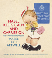
Mabel Keeps Calm And Carries On

`During the Second World War, I worked in an empty building by the Thames. It had been used by the Thames Conservancy Board. When war came, they moved out and I was moved in. I stayed there for most of the war. I never went down to an air raid shelter. I was too busy trying to make people laugh about wartime bread and sausages, instead of crying about them.` Mabel Lucie Attwell Mabel Lucie Attwell was one of Britain`s best-loved artists with her work touching generations, from those who grew up with her classic characters, Bunty and the Boo-Boos, to those who have read Charles Kingsley`s The Water Babies, which she famously illustrated. Her art has found its way into homes across the world through figurines, bathroom plaques and gift cards featuring her charming designs. Yet, many
of her most poignant and humorous illustrations were created to cheer a world at war. She painted prolifically throughout the First and Second World Wars, with postcards featuring her child-like characters and tongue-in-cheek captions that were typical of her saucy sense of humour. Despite suffering loss and hardship herself during the wars she continued to encourage people to `smile through the tears`.This book which brings a collection of her wartime postcards together exclusively for the first time, pays tribute to the indomitable spirit of this incredible woman and to her art that cannot fail to raise a smile today for young and old alike.
RIP - This product is no longer available on our network. It was last seen on 25.09.2019

This page now acts as a permanent archive for this product. Add more information using the comments box below to ensure it can still be found by future generations.

Use our search facility to see if it is available from an alternative contributor.
  • Availability: Out Of Stock
  • Supplier: Stanfords
  • SKU: 9780752489193
Availability: In Stock
£9.99

Product Description

` During the Second World War, I worked in an empty building by the Thames. It had been used by the Thames Conservancy Board. When war came, they moved out & I was moved in. I stayed there for most of the war. I never went down to an air raid shelter. I was too busy trying to make people laugh about wartime bread & sausages, instead of crying about them.` Mabel Lucie Attwell Mabel Lucie Attwell was one of Britain`s best-loved artists with her work touching generations, from those who grew up with her classic characters, Bunty & the Boo-Boos, to those who have read Charles Kingsley`s The Water Babies, which she famously illustrated. Her art has found its way into homes across the world through figurines, bathroom plaques & gift cards featuring her charming designs. Yet, many of her most poignant & humorous illustrations were created to cheer a world at war. She painted prolifically throughout the First & Second World Wars, with postcards featuring her child-like characters & tongue-in-cheek captions that were typical of her saucy sense of humour. Despite suffering loss & hardship herself during the wars she continued to encourage people to `smile through the tears`. This book which brings a collection of her wartime postcards together exclusively for the first time, pays tribute to the indomitable spirit of this incredible woman & to her art that cannot fail to make you smile today for young & old alike.

Reviews/Comments

Add New

Intelligent Comparison

Oooops!
We couldn't find anything!
Perhaps this product's unique.... Or perhaps we are still looking for comparisons!
Click to bump this page and we'll hurry up.

Price History

Vouchers

No voucher codes found.
Do you know a voucher code for this product or supplier? Add it to Insights for others to use.

Facebook

Jargon Buster

Bathroom - A room usually with a bath and/or shower
Humour - Something either verbal of physical that provides amusement and can provoke laughter
water - A chemical substance. Chemical formula H2O.
World - A physical grouping, commonly used to describe earth and everything associated with ti
Gift - Something that is presented without expecting anything in return
illustrations - Pictures typically in books and newspapers.
Classic - Something that is still like it was originally a high quality standard.
Tongue - The muscular organ found inside the mouth used for tasting.

Supplier Information

Stanfords
Stanfords was established in 1853 and opened their iconic Covent Garden flagship store in 1901. They have become the top retailer of maps, travel books and accessories in the UK and arguably offer the largest selection of maps and travel books worldwide. Famous names such as Captain Robert Falcon Scott, Ranulph Fiennes and Michael Palin have purchased from Stanfords. They now have a shop in Bristol and both stores together with other venues operate a calendar of events including talks, book signings and exhibitions. As a specialist map retailer, the map selection is comprehensive and includes road maps, street maps and walking maps from worldwide destinations, as well as a selection of world atlases and wall maps. Books include travel guides and travel literature. Stanfords also stock globes, from miniatures made of blue marble to magnificent floor-standing globes. The website features a selection of interesting articles on travel topics.
Page Updated: 2023-11-12 20:15:36

Community Generated Product Tags

Oh No! The productWIKI community hasn't generated any tags for this product yet!
Menu