More From Contributor

£12.99
Solimar Castro-Valdez is 18 & drunk on optimism when she embarks on a perilous journey across the US/ Mexican border. Weeks later she arrives on her cousin`s doorstep in Berkeley, California, dazed by first love, & pregnant. This was not the plan. But amid the uncertainty of new motherhood & her American identity, Soli learns that when you have just one precious possession, you guard it with your life. For Soli, motherhood becomes her dwelling & the boy at her breast becomes her hearth. Kavya Reddy has always followed her heart, much to her parents chagrin. A mostly contented chef at a UC Berkeley sorority house, the unexpected desire to have a child descends like a cyclone in Kavya`s mid-thirties. When she can`t get pregnant, this desire will test her marriage & her sanity. More than that, it will set Kavya & her husband on a collision course with Soli when she is detained & her infant son comes under Kavya`s care. As Kavya learns to be a mother
- the singing, story-telling, inventor-of-the-universe kind of mother she always fantasized about being
- she builds her love on a fault line, her heart wrapped around someone else`s child.LUCKY BOY is an emotional journey that will leave you certain of the redemptive beauty of this world. There are no bad guys in this story, no single obvious hero. Sekaran has taken real life & applied it to fiction; the results are moving & revelatory.

...
Archived Product
£9.99
Its beckoning paw has a cult fanbase, but the lucky cat is more than just a cute ornament. The iconic creature is a symbol of good fortune & used as a powerful lucky charm in shops & homes across Japan, China & beyond. The lucky cat (or maneki neko in Japanese) has a long history dating back to the 17th century that`s packed with fascinating folklore, serious symbolism & countless contemporary cat spin-offs. Its paw, bib, coin, collar & colours all have meaning. Did you know a pink cat will bring you luck in love, while a gold cat is all about wealth? Or that a left-pawed cat is used by businesses to attract customers, while a cat with a beckoning right paw is found in homes as talisman? Dive into this adorable book to find out all you need to know about the beautiful lucky cat. ...
Archived Product
£5.99
Originating in Japanese culture, Lucky Cat, or maneki-neko, is regarded as a charm that brings good fortune to its owner. Included herein is a mini Lucky Cat figure with motorized arm & a 32-page illustrated book on the history of this ancient talisman. ...
Archived Product
£8.99
Kingsley Amis` witty campus novel, ” Lucky Jim” is a comedy that skewers the hypocrisies & vanities of 1950s academic life. This ” Penguin Modern Classics” edition contains an introduction by David Lodge. Jim Dixon has accidentally fallen into a job at one of Britain`s new red brick universities. A moderately successful future in the History Department beckons
- as long as Jim can stave off the unwelcome advances of fellow lecturer Margaret, survive a madrigal-singing weekend at Professor Welch`s, deliver a lecture on ` Merrie England` & resist Christine, the hopelessly desirable girlfriend of Welch`s awful son Bertr&. Inspired by Amis`s friend, the poet Philip Larkin, Jim Dixon is a timeless comic character, adrift in a hopelessly gauche & pretentious world. Kingsley Amis (1922-1995), born in London, wrote poetry, criticism, & short stories, but is best remembered as the novelist whose works offered a comic deconstruction of post-war Britain. Amis explored his disillusionment with British society in novels such as ” Lucky Jim” (1954) & ” That Uncertain Feeling” (1955); his other works include ” The Green Man” (1970) ” Stanley & the Women” (1984), & ” The Old Devils” (1986) which won the Booker Prize. If you enjoyed ” Lucky Jim”, you might like Amis`s ” The King`s English”, also available in ” Penguin Modern Classics”. ”A flawless comic novel...I loved it then, as I do now. It has always made me laugh out loud.” (Helen Dunmore, ” The Times”). ”A brilliantly & preposterously funny book.” (” Guardian”).
...
Archived Product
£6.99
From Steve Light, the creator of Have You Seen My Dragon?, Have You Seen My Monster? & Swap!, comes a riotous romp backstage at the theatre! Lazlo is in love. So, with the perfect red rose in h&, he sets off to the theatre, where the girl of his dreams is starring in Alice in Wonderl&. But when a cat snatches the flower & dashes backstage, Lazlo is in for a bit of bad luck. & it`s no wonder, since, at the Peacock Theatre, they`ve broken every superstitious rule in the book. The chase is on
- past the tailor, into the orchestra, over the prop table.. . even through the Mad Hatter`s tea party! Will Lazlo catch the cheeky kitty in time to present the flower to his lady love?
...
Archived Product
£6.99
One morning, very early.. . one little girl called Lucy fast asleep in bed, with one very special teddy tucked in beside her. Lucy`s little brother Tom is the first to wake up, & tugs at her quilt. Now there are two children, wide awake & ready for the day!A story with numbers, as Lucy & Tom go through their day, exploring their world, counting, sharing & learning as they go. ...
Archived Product
£5.99
“ Spire of St. Marin’s Ludgate silhouetted against the bulk of St. Paul’s” in a series of prints of sepia photos of some of old London’s best loved landmarks, presented by Soho Publishing in an A3 (29.6 x 39.6 cm) format. Under the photo are brief notes about the area. Ideal for framing, these reproductions show many long gone or much changed sites & offer a unique way of decorating your home or office with photos of near by or close-to-your-heart parts of the capital. Please note: the prints are supplied flat rather than rolled, with an A3 protective piece of cardboard, so the package will be larger than the standard size letterbox. To see other titles in this series please click on the series link. ...
Archived Product
£6.39
A detailed topographic map of Ludlow from the Ordnance Survey Explorer series, covering Tenbury Wells & Cleobury Mortimer. Edition A2; Publication date September 2010 About this series: These highly detailed maps show all the administrative boundaries, settlements as small as isolated farms, the road network down to unfenced roads & country tracks, & field boundaries (hedges & drystone walls) which make navigation across the countryside much easier. Steep gradients on roads are indicated. Various landmarks, e.g. powerlines, archaeological sites, windmills, churches & lighthouses are shown & additional graphics indicate natural terrain features such as cliffs, scree, mud & vegetation variations. The contour interval is 5 metres in the lower parts of the country & 10 metres in the uplands, & spot heights are marked. Each map covers an area of 30 x 20km (i.e. approx. 19 x 12 miles), with some double-sided maps covering more, as indicated in the individual descriptions. The maps are fully GPS compatible, with the National Grid shown at 1km intervals & latitude & longitude indicated by margin ticks at 1'. The Explorer series has replaced the earlier, green-cover Pathfinder maps. The Explorer series is now complete & covers all of Engl&, Wales & Scotl&. Some sheets for popular areas like the National Parks are still branded as Outdoor Leisure (OL) maps, but are now included in this series as the cartography is the same as that in the Explorer Maps. The Explorer maps offer a substantial improvement on the Pathfinder series, with greater use of colour, larger area per map, & stronger emphasis on information for ramblers & tourists. This series is ideal for walking & other outdoor pursuits & each map shows a large amount of information for ramblers & tourists. Public rights of way are shown (except in Scotland), together with other routes with public access: National Trails & Recreational Paths, permitted paths & bridleways, & selected cycle routes. Open access land created under the Countryside & Rights of Way Act 2000 is marked. Tourist information

Includes::
caravan & camp sites, Park & Ride locations, recreation/leisure/sport centres, museums, historic buildings, English Heritage & National Trust sites, rural pubs, etc. The map legend is in English only, except for the tourist information content which is also in French & German.

...
Archived Product
£14.99
Ludlow, Tenbury Wells & Cleobury Mortimer area on a detailed topographic & GPS compatible map No. 203, waterproof version, from the Ordnance Survey’s 1:25, 000 Explorer series.MOBILE DOWNLOADS: this title & all the other OS Explorer maps include a code for downloading after purchase the digital version onto your smartphone or tablet for viewing on the OS smartphone app.OS EXPLORER SERIES: to see the list of all the titles in the OS Explorer series, both paper & waterproof versions, please click on the series link. The Explorer series, Ordnance Survey’s most detailed maps recommended for anyone enjoying outdoor activities, provides topographic coverage of Great Britain at 1:25, 000 on GPS compatible maps with hiking trails, cycling routes & extensive tourist information. Each printed map is available either on paper or as a waterproof & tear-resistant OS Active Map, as indicated in its title. Britain’s National Parks & other areas of particular tourist interest are presented on often double-sided OL (Outdoor Leisure) maps, whilst most standard format Explorers cover an area of 30 x 20km (approx. 19 x 12 miles). All three versions (paper, waterproof & digital) are the same & provide plenty of recreational & tourist information, indicating the traditional public right of way paths (except in Scotland where different laws apply), including bridleways & byways. National Trails & other long-distance paths are marked, as well as permissive footpaths or bridleways & on-road or traffic-free cycle routes with, where appropriate, their National/ Regional Cycle Network numbers. Boundaries of access land are clearly marked. A wide range of symbols provides additional tourist information, highlighting camping & caravanning sites, information offices & visitors’ centres, parking & picnicking places, country pubs, sport & recreational facilities including cycle hire locations & mountain biking trails, historic buildings & museums, etc. Exceptionally clear presentation of the landscape is provided by contours at 5m or in the uplands at 10m intervals, with additional spot heights plus colouring and/or graphics for different types of woodlands, orchards, heath, marshl&, scree or boulders, & other topographic features. For GPS users the maps have British National Grid lines at 1km intervals, with latitude & longitude given by margin ticks at 1`. Clearly laid out map legend

Includes::
French & German translations for the tourist information symbols.

...
Archived Product
£8.99
Ludlow, Tenbury Wells & Cleobury Mortimer area on a detailed topographic & GPS compatible map No. 203, paper version, from the Ordnance Survey’s 1:25, 000 Explorer series. MOBILE DOWNLOADS: this title & all the other OS Explorer maps include a code for downloading after purchase the digital version onto your smartphone or tablet for viewing on the OS smartphone app.OS EXPLORER SERIES: to see the list of all the titles in the OS Explorer series, both paper & waterproof versions, please click on the series link. The Explorer series, Ordnance Survey’s most detailed maps recommended for anyone enjoying outdoor activities, provides topographic coverage of Great Britain at 1:25, 000 on GPS compatible maps with hiking trails, cycling routes & extensive tourist information. Each printed map is available either on paper or as a waterproof & tear-resistant OS Active Map, as indicated in its title. Britain’s National Parks & other areas of particular tourist interest are presented on often double-sided OL (Outdoor Leisure) maps, whilst most standard format Explorers cover an area of 30 x 20km (approx. 19 x 12 miles). All three versions (paper, waterproof & digital) are the same & provide plenty of recreational & tourist information, indicating the traditional public right of way paths (except in Scotland where different laws apply), including bridleways & byways. National Trails & other long-distance paths are marked, as well as permissive footpaths or bridleways & on-road or traffic-free cycle routes with, where appropriate, their National/ Regional Cycle Network numbers. Boundaries of access land are clearly marked. A wide range of symbols provides additional tourist information, highlighting camping & caravanning sites, information offices & visitors’ centres, parking & picnicking places, country pubs, sport & recreational facilities including cycle hire locations & mountain biking trails, historic buildings & museums, etc. Exceptionally clear presentation of the landscape is provided by contours at 5m or in the uplands at 10m intervals, with additional spot heights plus colouring and/or graphics for different types of woodlands, orchards, heath, marshl&, scree or boulders, & other topographic features. For GPS users the maps have British National Grid lines at 1km intervals, with latitude & longitude given by margin ticks at 1`. Clearly laid out map legend

Includes::
French & German translations for the tourist information symbols.

...
Archived Product

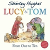
Lucy & Tom: From A To Z

Lucy and Tom know a lot of words- they have Books read to them at Bedtime. They know that D is for Dog, like the dogs that live on their street, F is for Friends, and P is for Park and for Playing. Join Lucy and Tom on a journey through their life, in this satisfying alphabet tale from master storyteller, Shirley Hughes.
RIP - This product is no longer available on our network. It was last seen on 25.09.2019

This page now acts as a permanent archive for this product. Add more information using the comments box below to ensure it can still be found by future generations.

Use our search facility to see if it is available from an alternative contributor.
  • Availability: Out Of Stock
  • Supplier: Stanfords
  • SKU: 9781782957256
Availability: In Stock
£6.99

Product Description

Lucy & Tom know a lot of words- they have Books read to them at Bedtime. They know that D is for Dog, like the dogs that live on their street, F is for Friends, & P is for Park & for Playing. Join Lucy & Tom on a journey through their life, in this satisfying alphabet tale from master storyteller, Shirley Hughes.

Reviews/Comments

Add New

Intelligent Comparison

Oooops!
We couldn't find anything!
Perhaps this product's unique.... Or perhaps we are still looking for comparisons!
Click to bump this page and we'll hurry up.

Price History

Vouchers

No voucher codes found.
Do you know a voucher code for this product or supplier? Add it to Insights for others to use.

Facebook

Jargon Buster

Friends - A close associate or a popular US based sitcom about a group of friends
Satisfying - A feeling of pleasure and fulfilment.

Supplier Information

Stanfords
Stanfords was established in 1853 and opened their iconic Covent Garden flagship store in 1901. They have become the top retailer of maps, travel books and accessories in the UK and arguably offer the largest selection of maps and travel books worldwide. Famous names such as Captain Robert Falcon Scott, Ranulph Fiennes and Michael Palin have purchased from Stanfords. They now have a shop in Bristol and both stores together with other venues operate a calendar of events including talks, book signings and exhibitions. As a specialist map retailer, the map selection is comprehensive and includes road maps, street maps and walking maps from worldwide destinations, as well as a selection of world atlases and wall maps. Books include travel guides and travel literature. Stanfords also stock globes, from miniatures made of blue marble to magnificent floor-standing globes. The website features a selection of interesting articles on travel topics.
Page Updated: 2023-11-12 20:15:36

Community Generated Product Tags

Oh No! The productWIKI community hasn't generated any tags for this product yet!
Menu