More From Contributor
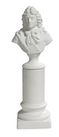
£5.99
Loughshore Trail Cycle Route at 1:100, 000 in a series of cycling maps from Sustrans, the charity behind developing UK’s National Cycle Network. The map is printed on light waterproof & tear-resistant synthetic paper & presents the area around Lough Neagh on two panels: a circular route around the lake including Antrim & Portadown, plus a spur northwards to Portgelnone. Each title in the Sustrans series of cycling maps covers either a single route, presented in sections on separate strip maps, or a wider area with the main cycling route (s) prominently highlighted but other recommendations for cyclists also marked. The area covered each map is shown on our website on its individual “coverage” image. The route has markers indicating steep gradients, controlled access, distances & possible danger points. Route profiles indicate riding surface & the density of traffic (main road, minor road & traffic-free) &, where appropriate, street plans show the course of the route across towns & cities. On maps covering a wider area around the main National Cycle Route suggestions of possible day ride excursions are also marked. A range of symbols highlight various facilities & places of interest, including tourist information centres, youth hostels, cafes & pubs, grocery shops, cycle shops & hire, historical & natural sites, etc. For access by rail, the rail network is shown with stations &, where appropriate, metro stations are also marked. Topography is shows by altitude colouring. Unless specifically indicated in the individual description, the maps do not show British National Grid lines for GPS. Each title also contains contact addresses for various useful organizations, etc. Many titles are printed on light, waterproof & tear-resistant synthetic paper. ...
Archived Product
£2.95
Loughton North in 1895 in a fascinating series of reproductions of old Ordnance Survey plans in the Alan Godfrey Editions, ideal for anyone interested in the history of their neighbourhood or family. Selected towns in Great Britain & Ireland are covered by maps showing the extent of urban development in the last decades of the 19th & early 20th century. In this title: the map covers much of the central & northern part of Loughton, stretching from St Mary's church northward to Arewater Green & Baldwin's Hill. Features include Ash Green, Pump Hill, The Hole, Border's Farm, much of High Road, Albion Granaries, St John the Baptist church, Rectory Green, Marlcroft House, Trapshill Farm, etc. On the reverse is a list of private residents from an 1895 directory. About the Alan Godfrey Editions of the 25 ...
Archived Product
£3.50
Loughton North in 1895 in a fascinating series of reproductions of old Ordnance Survey plans in the Alan Godfrey Editions, ideal for anyone interested in the history of their neighbourhood or family. The map covers much of the central & northern part of Loughton, stretching from St Mary`s church northward to Arewater Green & Baldwin`s Hill. Features include Ash Green, Pump Hill, The Hole, Border`s Farm, much of High Road, Albion Granaries, St John the Baptist church, Rectory Green, Marlcroft House, Trapshill Farm, etc. On the reverse is a list of private residents from an 1895 directory. About the Alan Godfrey Editions of the 25” OS Series Selected towns in Great Britain & Ireland are covered by maps showing the extent of urban development in the last decades of the 19th & early 20th century. The plans have been taken from the Ordnance Survey mapping & reprinted at about 15 inches to one mile (1:4, 340). On the reverse most maps have historical notes & many also include extracts from contemporary directories. Most maps cover about one mile (1.6kms) north/south, one & a half miles (2.4kms) across; adjoining sheets can be combined to provide wider coverage.FOR MORE INFORMATION & A COMPLETE LIST OF ALL AVAILABLE TITLES PLEASE CLICK ON THE SERIES LINK. ...
Archived Product
£3.50
Loughton South in 1895 in a fascinating series of reproductions of old Ordnance Survey plans in the Alan Godfrey Editions, ideal for anyone interested in the history of their neighbourhood or family. The map covers the southern part of Loughton, stretching from Allard`s Grove & Lopping Hall southward to the boundary with Buckhurst Hill UDC. Features include railway with Loughton station, Crown Hotel, St John`s College, Alderton Hall, Newnham House, North Farm, Beech Farm. An 1895 commercial directory is on the reverse. About the Alan Godfrey Editions of the 25” OS Series Selected towns in Great Britain & Ireland are covered by maps showing the extent of urban development in the last decades of the 19th & early 20th century. The plans have been taken from the Ordnance Survey mapping & reprinted at about 15 inches to one mile (1:4, 340). On the reverse most maps have historical notes & many also include extracts from contemporary directories. Most maps cover about one mile (1.6kms) north/south, one & a half miles (2.4kms) across; adjoining sheets can be combined to provide wider coverage.FOR MORE INFORMATION & A COMPLETE LIST OF ALL AVAILABLE TITLES PLEASE CLICK ON THE SERIES LINK. ...
Archived Product
£11.50
Topographic survey of France at 1:25, 000 in IGN`s excellent TOP25 / Série Bleue series. All the maps are GPS compatible, with a 1km UTM grid plus latitude & longitude lines at 5’ intervals. Contours are at 5m intervals except for mountainous areas where the maps have contours at 10m intervals, vividly enhanced by hill shading & graphics for rocky terrain. Colouring with graphics indicates different types of vegetation or land use (deciduous or coniferous forests, moors, orchards, vineyards, etc). PLEASE NOTE: coverage of France at this scale is currently being revised – the format & the presentation of each title are indicated by the letters at the end of its Sheet Reference number (e.g. 0416ET, 3531ETR, 1923SB, etc.)MAPS WITH FULL TOURIST OVERPRINT & AN ENGLISH MAP LEGEND: all TOP25 maps & the SB editions of Série Bleue have an overprint highlighting waymarked walking trails including long-distance GR routes &, where appropriate, ski routes. Symbols indicate campsites, gîtes d’etape, refuges, equestrian centres & other recreational facilities or sites, tourist information centres, cultural heritage, etc. Towns & locations of particular interest are highlighted.- ET or OT = single-sided TOP25 map covering approx. 29x 21 km / 18x 13 miles.- ETR or OTR = waterproof & tear resistant TOP25 map covering the same area as the corresponding ET or OT number, but double-sided, printed on a smaller size sheet with a good overlap between the sides.- SB = Série Bleue map with full tourist overprint; these maps, first introduced in summer 2014, each cover approx. 29x 24km / 18x 15 miles.SÉRIE BLEUE maps with numbers ending in E (Est) or O (Ouest): most editions now indicate the GR routes, but do not show any other tourist information. Map legend is in French only. Each map covers approx. 14x 20km / 9x 12 miles. ...
Archived Product
£24.99
Louis XV- Bisque Porcelain leaves all fine details unhidden. The originals of the busts were purchased at a provincial French auction, these replicas are exact down to the finest detail. We’ve always been attracted to the fine & subtle detail of bisque porcelain. Glazing tends to smooth over details & make things blander. Busts like these were en vogue in the first half of the 19th century, & often taken home by Grand Tourm travelers who were always on the lookout for authentic historical artifacts. 7 (L) x 9 (W) x 26 (H) cm If we do not have this item in stock we will order it for you from our supplier. Delivery generally takes 3 weeks within the UK. For overseas delivery queries please email sales@stanfords.co.uk ...
Archived Product
£9.99
Louisiana on a laminated & waterproof Easy-to-Fold map from Rand Mc Nally, the country’s leading publisher of road maps & street plans. For clarity of road information Rand Mc Nally state maps present the road network on a plain background, with no or little topographic detail. Driving distances are indicated on all principal highways & on many local routes. National or state parks & other protected areas, Indian Reservations & restricted entry military zones are highlighted & symbols indicate campsites, rest areas, various places of interest, etc. Each map shows local administrative boundaries with names of the counties, is indexed & gives geographical coordinates as margin ticks usually at 1° intervals. Rand Mc Nally state maps are available in two formats: double-sided Easy-to-Read maps with numerous enlargements for cities and/or most visited areas, & laminated Easy-to-Fold maps in a more handy format but with smaller print. TO SEE THE LIST OF RAND Mc NALLY STATE MAPS PLEASE CLICK ON THE SERIES LINK. ...
Archived Product
£6.99
Louisiana Easy-to-Read map from Rand Mc Nally, US leading publisher of road maps & street plans, in their extensive series of state maps. Additional panels provide enlargements for: New Orleans & vicinity with a street plan of the downtown area, Baton Rouge, Alexandria, Lafayette, Lake Charles, Monroe, & Shrevenport. For clarity of road information Rand Mc Nally state maps present the road network on a plain background, with no or little topographic detail. Driving distances are indicated on all principal highways & on many local routes. National or state parks & other protected areas, Indian Reservations & restricted entry military zones are highlighted & symbols indicate campsites, rest areas, various places of interest, etc. Each map shows local administrative boundaries with names of the counties, is indexed & gives geographical coordinates as margin ticks usually at 1° intervals. Rand Mc Nally state maps are available in two formats: double-sided Easy-to-Read maps with numerous enlargements for cities and/or most visited areas, & laminated Easy-to-Fold maps in a more handy format but with smaller print. TO SEE THE LIST OF RAND Mc NALLY STATE MAPS PLEASE CLICK ON THE SERIES LINK. ...
Archived Product
£19.99
Louisiana Recreational Atlas & Gazetteer at 1:181, 000 approx. in a series of large format paperback state atlases from De Lorme, with detailed, contoured, GPS compatible topographic mapping, plus a street plan of central New Orleans. Recreational information

Includes::
lists of unique natural features, attractions, museums/historic sites, scenic drives, gardens. Tables are also provided listing, where appropriate with facilities, campgrounds, recreational areas, hiking trails, golf courses, natural & scenic rivers, canoeing sites, salt water fishing, plus fishing & hunting sites each with a list of species. Each title in this De Lorme series covers one state & presents it at a scale much more detailed than used on most state road maps. Particularly popular areas are often also presented on enlargements. The maps are contoured, show variation of terrain (deserts, glaciers, wetlands, woodlands, etc) & have latitude & longitude and/or UTM grid lines for GPS use. Various types of protected areas are distinguished by the colouring of their boundaries, e.g. national or state parks, forests, etc. Also marked are Indian Reservations & restricted entry military zones. Road network is shown in much more detail than on other state mapping, with local roads, unsurfaced back roads & tracks, forest trails, etc. Where appropriate, old historical routes are marked. Railway lines & local airports or landing strips are included & the maps also indicate administrative boundaries. Symbols highlight various recreational areas & facilities such as campgrounds, unique natural features, etc. Each title contains extensive lists of outdoor adventure sites (grouped into activities such as hiking, biking, paddling, fishing, skiing, etc.), diverse family outing sites, campgrounds, & tables showing what facilities can be found in the state’s recreational areas. Each atlas also has an index of localities. To see the list of titles in this series please click on the series link.

...
Archived Product
£30.00
Detailed physical wall map of Louisiana State at a scale of 1:500, 000. The cartography shows relief through a stunning, ...
Archived Product

Louis XIV

Louis XIV- Bisque Porcelain leaves all fine details unhidden. The originals of the busts were purchased at a provincial French auction, these replicas are exact down to the finest detail. We’ve always been attracted to the fine and subtle detail of bisque porcelain. Glazing tends to smooth over details and make things blander. Busts like these were en vogue in the first half of the 19th century, and often taken home by Grand Tourm travelers who were always on the lookout for authentic historical artifacts. 7(L) x 9(W) x 26(H) cmIf we do not have this item in stock we will order it for you from our supplier. Delivery generally takes 3 weeks within the UK. For overseas delivery queries please email sales@stanfords.co.uk
RIP - This product is no longer available on our network. It was last seen on 25.09.2019

This page now acts as a permanent archive for this product. Add more information using the comments box below to ensure it can still be found by future generations.

Use our search facility to see if it is available from an alternative contributor.
  • External links may include paid for promotion
  • Availability: Out Of Stock
  • Supplier: Stanfords
  • SKU: 0781934578826
Availability: In Stock
£24.99

Product Description

Louis XIV- Bisque Porcelain leaves all fine details unhidden. The originals of the busts were purchased at a provincial French auction, these replicas are exact down to the finest detail. We’ve always been attracted to the fine & subtle detail of bisque porcelain. Glazing tends to smooth over details & make things blander. Busts like these were en vogue in the first half of the 19th century, & often taken home by Grand Tourm travelers who were always on the lookout for authentic historical artifacts. 7 (L) x 9 (W) x 26 (H) cm If we do not have this item in stock we will order it for you from our supplier. Delivery generally takes 3 weeks within the UK. For overseas delivery queries please email sales@stanfords.co.uk

Reviews/Comments

Add New

Intelligent Comparison

Oooops!
We couldn't find anything!
Perhaps this product's unique.... Or perhaps we are still looking for comparisons!
Click to bump this page and we'll hurry up.

Price History

Vouchers

No voucher codes found.
Do you know a voucher code for this product or supplier? Add it to Insights for others to use.

Facebook

Jargon Buster

Porcelain - A ceramic material
UK - United Kingdom - An island nation in Europe
email - An electronic communication method. Short for Electronic Mail.
delivery - The method by which something is delivered from one location to another
Home - A place of permanent residence for families.
Subtle - Something that is delicate and not to harsh, can be difficult to describe.

Supplier Information

Stanfords
Stanfords was established in 1853 and opened their iconic Covent Garden flagship store in 1901. They have become the top retailer of maps, travel books and accessories in the UK and arguably offer the largest selection of maps and travel books worldwide. Famous names such as Captain Robert Falcon Scott, Ranulph Fiennes and Michael Palin have purchased from Stanfords. They now have a shop in Bristol and both stores together with other venues operate a calendar of events including talks, book signings and exhibitions. As a specialist map retailer, the map selection is comprehensive and includes road maps, street maps and walking maps from worldwide destinations, as well as a selection of world atlases and wall maps. Books include travel guides and travel literature. Stanfords also stock globes, from miniatures made of blue marble to magnificent floor-standing globes. The website features a selection of interesting articles on travel topics.
Page Updated: 2023-11-12 20:15:36

Community Generated Product Tags

Oh No! The productWIKI community hasn't generated any tags for this product yet!
Menu