More From Contributor
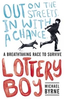
£5.99
This busy book will take you on a tour of London`s most famous sights, from bustling Trafalgar Square to majestic Buckingham Palace, Camden Market & Piccadilly Circus. Every picture is crammed with things to spot & talk about, & there are puzzles, games & four pages of stickers too. The puzzle answers are included at the back of the book. ...
Archived Product
£5.99
There are cute animals for children to spot on a sandy beach, in a thrilling adventure park, by the pool & lots of other exciting places in this holiday look-&-talk book. Little children can count the cars on the rollercoaster, spot turtles at the aquarium & use stickers to fill up a sunny beach scene. Each scene is packed with things to spot, & there are puzzles, games, stickers & lots of things to talk about too. Perfect for developing children’s essential first skills such as matching & visual discrimination. ...
Archived Product
£6.99
” Clear, direct, involving text, coupled with vivid, delicate illustrations make for a truly special work of non-fiction.”
-
...
Archived Product
£12.99
Lotschental – Aletschgebiet area of the Bernese Oberland at 1:33, 333 on light, waterproof & tear-resistant map No. 3324T published by Swisstopo in cooperation with the Swiss Hiking Federation. Cartography is the same as in Swisstopo’s 50K hiking maps, simply enlarged to 1:33, 333 for extra clarity but without additional information. The title

Includes::
a table with timings & facilities for three recommended routes.1:33, 333 editions of Swisstopo’s hiking maps have cartography identical to the standard version of the country’s 1:50, 000 topographic survey, highly regarded for its superb use of graphic relief & hill shading to provide an almost 3-D picture of Switzerland`s mountainous terrain. Contours are at 20m intervals. An overprint highlights routes maintained by the SHF, distinguishing between hiking routes, mountain routes requiring proper footwear, & alpine routes where equipment is needed. Paths which are part of the national or regional network of long-distance hiking routes are specially marked & in the more recent editions are annotated with their official numbers. The maps show mountain huts, refuges & in remote areas also inns, plus roads with bus service & the positions of bus stops. All the maps have a 1-km grid of the Swiss national coordinates. For a list of all the titles in this series, please click on the series link.

...
Archived Product
£22.99
The best rides in the freeride hot spots of the Alps – this is the simple formula of the Freeride Maps. The first map available to freeriders is making the locals freeride knowledge available to a broad public. All ridable slopes, drops & couloirs are marked as freeride corridors in different colours for three difficulty ratings: blue for technically easy terrain, yellow requires advanced to very advanced ability & red is extremely difficult terrain that is partially exposed & therefore reserved to crack riders. Short ascents are marked with red lines. The Freeride Maps are based on topographic maps 1:25, 000. They contain all essential information about the terrain that is necessary for planning & going freeriding. The maps are printed on water resistant & indestructible paper. On the back side, the maps include all relevant planning, safety & rescue information. ...
Archived Product
£4.99
A brand new blue Early Reader about two little girls who love gardening, with tips on growing your own pumpkins in time for Halloween from one of the UK`s top gardening bloggers. Early Readers are stepping stones from picture books to reading books, perfect for building confidence in new readers & reluctant readers. A blue Early Reader is perfect for sharing & reading together. A red Early Reader is the next step on your reading journey. Halloween is coming & Lottie & Dottie are growing their very own pumpkins. From making yummy soup to carving scary faces, there are lots of things for them to make & do. Perfect for budding gardeners. Contains instructions on how to grow your own pumpkins. ...
Archived Product
£6.99
A feel-good, rhyming picture book, packed full of outrageously funny otters from multi-award-winning author, Jeanne Willis, with hilarious illustrations by Leonie Lord. When little Lottie Potter goes to Trotter`s Otter shop to buy a new pet, she certainly doesn`t expect to find quite so many kinds. There are spotty otters, potty otters, snotty otters & tangled-in-a-knotty otters
- to name but a few! But what will she do when the otter she chooses turns out to be a rotter? A side-splittingly funny, fast-paced rhyming romp that`s a joy to read out loud
- again & again!

...
Archived Product
£12.99
Topographic survey of France at 1:25, 000 in IGN`s excellent TOP25 / Série Bleue series. All the maps are GPS compatible, with a 1km UTM grid plus latitude & longitude lines at 5’ intervals. Contours are at 5m intervals except for mountainous areas where the maps have contours at 10m intervals, vividly enhanced by hill shading & graphics for rocky terrain. Colouring with graphics indicates different types of vegetation or land use (deciduous or coniferous forests, moors, orchards, vineyards, etc). PLEASE NOTE: coverage of France at this scale is currently being revised – the format & the presentation of each title are indicated by the letters at the end of its Sheet Reference number (e.g. 0416ET, 3531ETR, 1923SB, etc.)MAPS WITH FULL TOURIST OVERPRINT & AN ENGLISH MAP LEGEND: all TOP25 maps & the SB editions of Série Bleue have an overprint highlighting waymarked walking trails including long-distance GR routes &, where appropriate, ski routes. Symbols indicate campsites, gîtes d’etape, refuges, equestrian centres & other recreational facilities or sites, tourist information centres, cultural heritage, etc. Towns & locations of particular interest are highlighted.- ET or OT = single-sided TOP25 map covering approx. 29x 21 km / 18x 13 miles.- ETR or OTR = waterproof & tear resistant TOP25 map covering the same area as the corresponding ET or OT number, but double-sided, printed on a smaller size sheet with a good overlap between the sides.- SB = Série Bleue map with full tourist overprint; these maps, first introduced in summer 2014, each cover approx. 29x 24km / 18x 15 miles.SÉRIE BLEUE maps with numbers ending in E (Est) or O (Ouest): most editions now indicate the GR routes, but do not show any other tourist information. Map legend is in French only. Each map covers approx. 14x 20km / 9x 12 miles. ...
Archived Product
£13.99
Loudenvielle at la vallée du Louron à pied, FFRP topo-guide Ref. No.ST06, with 20 day walks of varying length & difficulty near Loudenvielle in the French Pyrenees. Each walk is presented on a separate colour extract from IGN’s topographic survey of France at 1:25, 000, with its description cross-referenced to the map. Current edition of this title was published in June 2014. To see the list of other FFRP guides with day walks please click on the series link.ABOUT THE FFRP (Fédération française de la randonnée pédestre) TOPOGUIDES: published in a handy A5 paperback format, the guides are the best companions for hiking in France. In addition to their topo-guides to the long-distance GR routes FFRP also publish an extensive range of guides with local day walks. Each walk in presented on a colour extract from IGN`s 1:50, 000 or 1:25, 000 topographic survey mapping overprinted with the route, with important points cross-referenced to the accompanying text, in French only, placed on the adjoining page. For each walk the guides also indicate the degree of difficulty & provide information on length, time & change in altitude, waymarking signs, access by road & parking facilities. An “info practiques” section of the guide indicates where shops, restaurants & accommodation can be found. The guides are published on high quality paper & include descriptions of the most interesting aspects of the surrounding region: historical & cultural sites, local specialties, fauna & flora, etc, all illustrated with colour photos. ...
Archived Product
£11.50
Topographic survey of France at 1:25, 000 in IGN`s excellent TOP25 / Série Bleue series. All the maps are GPS compatible, with a 1km UTM grid plus latitude & longitude lines at 5’ intervals. Contours are at 5m intervals except for mountainous areas where the maps have contours at 10m intervals, vividly enhanced by hill shading & graphics for rocky terrain. Colouring with graphics indicates different types of vegetation or land use (deciduous or coniferous forests, moors, orchards, vineyards, etc). PLEASE NOTE: coverage of France at this scale is currently being revised – the format & the presentation of each title are indicated by the letters at the end of its Sheet Reference number (e.g. 0416ET, 3531ETR, 1923SB, etc.)MAPS WITH FULL TOURIST OVERPRINT & AN ENGLISH MAP LEGEND: all TOP25 maps & the SB editions of Série Bleue have an overprint highlighting waymarked walking trails including long-distance GR routes &, where appropriate, ski routes. Symbols indicate campsites, gîtes d’etape, refuges, equestrian centres & other recreational facilities or sites, tourist information centres, cultural heritage, etc. Towns & locations of particular interest are highlighted.- ET or OT = single-sided TOP25 map covering approx. 29x 21 km / 18x 13 miles.- ETR or OTR = waterproof & tear resistant TOP25 map covering the same area as the corresponding ET or OT number, but double-sided, printed on a smaller size sheet with a good overlap between the sides.- SB = Série Bleue map with full tourist overprint; these maps, first introduced in summer 2014, each cover approx. 29x 24km / 18x 15 miles.SÉRIE BLEUE maps with numbers ending in E (Est) or O (Ouest): most editions now indicate the GR routes, but do not show any other tourist information. Map legend is in French only. Each map covers approx. 14x 20km / 9x 12 miles. ...
Archived Product

Lottery Boy

Reminiscent of Slumdog Millionaire, this contemporary adventure story set on the streets of London follows a boy whose luck is about to change. Since his mother`s death, Bully has lost his old life. Living rough with his dog, Jack, he can`t imagine his future. But one day, in the last birthday card she ever gave him, he finds a winning lottery ticket, a last gift from his mum that suddenly offers such hope. If only he can get to his prize on time. Life is not that simple. Bully`s struggle to survive has just got a whole lot harder. They`re after him on the streets, everyone wants a piece of him. And even if he does claim all that money, will he really be winning what he needs the most?
RIP - This product is no longer available on our network. It was last seen on 25.09.2019

This page now acts as a permanent archive for this product. Add more information using the comments box below to ensure it can still be found by future generations.

Use our search facility to see if it is available from an alternative contributor.
  • External links may include paid for promotion
  • Availability: Out Of Stock
  • Supplier: Stanfords
  • SKU: 9781406358292
Availability: In Stock
£6.99

Product Description

Reminiscent of Slumdog Millionaire, this contemporary adventure story set on the streets of London follows a boy whose luck is about to change. Since his mother`s death, Bully has lost his old life. Living rough with his dog, Jack, he can`t imagine his future. But one day, in the last birthday card she ever gave him, he finds a winning lottery ticket, a last gift from his mum that suddenly offers such hope. If only he can get to his prize on time. Life is not that simple. Bully`s struggle to survive has just got a whole lot harder. They`re after him on the streets, everyone wants a piece of him. & even if he does claim all that money, will he really be winning what he needs the most?

Reviews/Comments

Add New

Intelligent Comparison

Oooops!
We couldn't find anything!
Perhaps this product's unique.... Or perhaps we are still looking for comparisons!
Click to bump this page and we'll hurry up.

Price History

Vouchers

No voucher codes found.
Do you know a voucher code for this product or supplier? Add it to Insights for others to use.

Facebook

Jargon Buster

Contemporary - Modern era design
Contemporary - A design reference to indicate post war modern design
Gift - Something that is presented without expecting anything in return
Day - The time it takes a planet or other space objects to complete one rotation.
Set - a group of items usually related to one another. Some objects cannot function without the complete set of items.
Adventure - an undertaking of an exciting challenge or experience.
Contemporary - An object that is living in the same time.
Simple - Basic, easy no difficulty in understanding.

Supplier Information

Stanfords
Stanfords was established in 1853 and opened their iconic Covent Garden flagship store in 1901. They have become the top retailer of maps, travel books and accessories in the UK and arguably offer the largest selection of maps and travel books worldwide. Famous names such as Captain Robert Falcon Scott, Ranulph Fiennes and Michael Palin have purchased from Stanfords. They now have a shop in Bristol and both stores together with other venues operate a calendar of events including talks, book signings and exhibitions. As a specialist map retailer, the map selection is comprehensive and includes road maps, street maps and walking maps from worldwide destinations, as well as a selection of world atlases and wall maps. Books include travel guides and travel literature. Stanfords also stock globes, from miniatures made of blue marble to magnificent floor-standing globes. The website features a selection of interesting articles on travel topics.
Page Updated: 2023-11-12 20:15:36

Community Generated Product Tags

Oh No! The productWIKI community hasn't generated any tags for this product yet!
Menu