More From Contributor
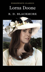
£9.99
`I cannot tune a harp or play a lyre, but I know how to make a small city great.` Themistocles After almost three thousand years, the brilliant achievements of ancient Athens
- the philosophy of Plato, the birth of modern democracy, architecture & theatre
- continue to tower over modern culture. Lords of the Sea seeks to write the first modern biography of this extraordinary ancient city from a dramatic new angle
- the sea. How did a humble, unremarkable fishing village turn itself into a dazzling democratic empire fuelled by silver, intellect, sheer cunning, sophisticated rowing power, & blood shed during heroic battles, to become the most intrepid free superpower the world has ever known? Lords of the Sea brings together the impressive modern scholarly knowledge of ancient Athens. Its narrative relies on ancient literature (the histories, plays, speeches, poetry, inscriptions), the latest archaeological discoveries (bronze rams, ship houses & docks, naval monuments), first-hand study of every important theatre of war, & insight into a society that was one of the few in history to grant extreme sexual license to free adult males. Famous names, such as Themistocles, Pericles, Socrates, the treacherous Alcibiades, Thucydides, Sophocles, Euripides, Plato & Aristotle, appear in vividly-drawn portraits as the Athenians themselves would have seen & judged them at the time. The dramatic rise, decline & fall of ancient Athens is much more than a gripping historical tale. Lords of the Sea shows that it is one of the first struggles of everything that makes the human race potentially great.


...
Archived Product
£29.95
One of the titles in a series of maps of the administrative departments of Peru, with topography shown by altitude colouring & spot heights. Most maps also indicate cultivated areas. Scales vary considerably, given different sizes of the departments. Railways & four different types of roads & dirt tracks are shown, as well as local airports & aerodromes. The maps also show the subdivisions of the departments into provinces & districts, indicating administrative capital of each unit. Most sheets also include a panel with general information about the state (e.g. population distribution, climate, etc.). Latitude & longitude grid is drawn at 1º intervals, making this series very useful for identifying the locations of small places on the 1:100, 000 topographic survey of the country. Map legend is in Spanish only. Publication dates vary from mid-1980s to mid-1990s, with a handful of titles revised later. Each map shows one department only & no detail of any kind is given for the adjacent departments, beyond their names. ...
Archived Product
£17.99
Topographic mapping from Mexico’s national survey agency, Instituto Nacional de Estadística, Geografía e Informática. The maps have contours at 20m intervals with relief shading & indicate various types of terrain & vegetation, e.g. dense vegetation, cultivated areas, swamps, sand dunes, salt pans, etc. UTM grid is at 10km intervals, with latitude & longitude shown by margin ticks at intervals of 5`. Map legend is in Spanish only. To see the other titles in this series please click on the series link. ...
Archived Product
£8.50
Street plan of the Lorient
- Lanester
- Larmor-Plage area, part of an extensive series covering French cities & towns from

...
Archived Product
£12.99
Topographic survey of France at 1:25, 000 in IGN`s excellent TOP25 / Série Bleue series. All the maps are GPS compatible, with a 1km UTM grid plus latitude & longitude lines at 5’ intervals. Contours are at 5m intervals except for mountainous areas where the maps have contours at 10m intervals, vividly enhanced by hill shading & graphics for rocky terrain. Colouring with graphics indicates different types of vegetation or land use (deciduous or coniferous forests, moors, orchards, vineyards, etc). MAPS WITH FULL TOURIST OVERPRINT & AN ENGLISH MAP LEGEND: all TOP25 maps & the SB editions of Série Bleue have an overprint highlighting waymarked walking trails including long-distance GR routes &, where appropriate, ski routes. Symbols indicate campsites, gîtes d’etape, refuges, equestrian centres & other recreational facilities or sites, tourist information centres, cultural heritage, etc. Towns & locations of particular interest are highlighted.- ET or OT = single-sided TOP25 map covering approx. 29x 21 km / 18x 13 miles.- ETR or OTR = waterproof & tear resistant TOP25 map covering the same area as the corresponding ET or OT number, but double-sided, printed on a smaller size sheet with a good overlap between the sides.- SB = Série Bleue map with full tourist overprint; these maps, first introduced in summer 2014, each cover approx. 29x 24km / 18x 15 miles.SÉRIE BLEUE maps with numbers ending in E (Est) or O (Ouest): most editions now indicate the GR routes, but do not show any other tourist information. Map legend is in French only. Each map covers approx. 14x 20km / 9x 12 miles. ...
Archived Product
£11.50
Topographic survey of France at 1:25, 000 in IGN`s excellent TOP25 / Série Bleue series. All the maps are GPS compatible, with a 1km UTM grid plus latitude & longitude lines at 5’ intervals. Contours are at 5m intervals except for mountainous areas where the maps have contours at 10m intervals, vividly enhanced by hill shading & graphics for rocky terrain. Colouring with graphics indicates different types of vegetation or land use (deciduous or coniferous forests, moors, orchards, vineyards, etc). PLEASE NOTE: coverage of France at this scale is currently being revised – the format & the presentation of each title are indicated by the letters at the end of its Sheet Reference number (e.g. 0416ET, 3531ETR, 1923SB, etc.)MAPS WITH FULL TOURIST OVERPRINT & AN ENGLISH MAP LEGEND: all TOP25 maps & the SB editions of Série Bleue have an overprint highlighting waymarked walking trails including long-distance GR routes &, where appropriate, ski routes. Symbols indicate campsites, gîtes d’etape, refuges, equestrian centres & other recreational facilities or sites, tourist information centres, cultural heritage, etc. Towns & locations of particular interest are highlighted.- ET or OT = single-sided TOP25 map covering approx. 29x 21 km / 18x 13 miles.- ETR or OTR = waterproof & tear resistant TOP25 map covering the same area as the corresponding ET or OT number, but double-sided, printed on a smaller size sheet with a good overlap between the sides.- SB = Série Bleue map with full tourist overprint; these maps, first introduced in summer 2014, each cover approx. 29x 24km / 18x 15 miles.SÉRIE BLEUE maps with numbers ending in E (Est) or O (Ouest): most editions now indicate the GR routes, but do not show any other tourist information. Map legend is in French only. Each map covers approx. 14x 20km / 9x 12 miles. ...
Archived Product
£18.99
From childhood family day trips to Loch Lomond, to her days as TVam`s roving correspondent, Lorraine Kelly has covered the length & breadth of Scotl&. But certain special places tug at her heartstrings & lure her back time & time again. Travelling to the highlands & islands & all her favourite places in between, this is Lorraine`s personal journey around her beautiful & beguiling country. Each & every stop gives rise to fascinating stories & memories along the way, from her adopted home of Dundee to the wild & remote islands of St Kilda. She revisits childhood haunts in Glasgow, indulges in a spot of whisky-tasting on the island of Islay & reveals what led her to once arrive in Edinburgh pushing a pram & wearing a pair of rollerskates. She rediscovers the joys of the natural wilderness in the Highlands, visits a dramatic Viking fire festival in Shetland & recalls the week she & her family spent hunting the Loch Ness monster... Beautifully illustrated with stunning original photographs, Lorraine Kelly`s Scotland is a celebration of a gloriously diverse country with a deep & rich heritage, told with all Lorraine`s characteristic warmth & humour. ...
Archived Product
£14.99
Lorraine Guide Vert *FRENCH Edition* in Michelin’s Green Guide series covering France, with all the regions available either in English editions or in French versions. Drawing on Michelin’s long experience, the guides are renowned for their individual ‘star rating’ of sights & attractions. Listings in each guide are organized alphabetically, allowing readers to access information quickly. Towns are given overall star rating, with their sights & attractions also rated individually. Where appropriate, a street plan of the town centre is provided, indicating car parks & accompanied by an index of main streets & a list of sights highlighted on it. For many towns a recommended sightseeing tour is also marked on the plan. Entries for important churches are accompanied by detailed plans. Recommended car tours have overview maps showing road numbers & locations of the sights. Where necessary, the guides give opening hours & contact details. Many entries have an “ Address Book” section with Michelin’s recommendations for where to stay & where to eat. Each guide has a very extensive introductory section with practical information & pre-trip tips, chapters on history, art & culture (particularly strong on architectural styles, explained by excellent drawings), fauna & flora, etc. Fold-out flaps in the book covers provide an overview of the recommended sights and/or car tours.* * French language guides* have a larger number of individual entries than included in the corresponding English titles, as well as more exhaustive descriptions, with wider coverage of local history and/or famous people connected with a given location.* * English language guides* have more recommendations for car tours. The “ Address Book” sections often include shopping suggestions. ...
Archived Product
£11.50
Topographic survey of France at 1:25, 000 in IGN`s excellent TOP25 / Série Bleue series. All the maps are GPS compatible, with a 1km UTM grid plus latitude & longitude lines at 5’ intervals. Contours are at 5m intervals except for mountainous areas where the maps have contours at 10m intervals, vividly enhanced by hill shading & graphics for rocky terrain. Colouring with graphics indicates different types of vegetation or land use (deciduous or coniferous forests, moors, orchards, vineyards, etc). PLEASE NOTE: coverage of France at this scale is currently being revised – the format & the presentation of each title are indicated by the letters at the end of its Sheet Reference number (e.g. 0416ET, 3531ETR, 1923SB, etc.)MAPS WITH FULL TOURIST OVERPRINT & AN ENGLISH MAP LEGEND: all TOP25 maps & the SB editions of Série Bleue have an overprint highlighting waymarked walking trails including long-distance GR routes &, where appropriate, ski routes. Symbols indicate campsites, gîtes d’etape, refuges, equestrian centres & other recreational facilities or sites, tourist information centres, cultural heritage, etc. Towns & locations of particular interest are highlighted.- ET or OT = single-sided TOP25 map covering approx. 29x 21 km / 18x 13 miles.- ETR or OTR = waterproof & tear resistant TOP25 map covering the same area as the corresponding ET or OT number, but double-sided, printed on a smaller size sheet with a good overlap between the sides.- SB = Série Bleue map with full tourist overprint; these maps, first introduced in summer 2014, each cover approx. 29x 24km / 18x 15 miles.SÉRIE BLEUE maps with numbers ending in E (Est) or O (Ouest): most editions now indicate the GR routes, but do not show any other tourist information. Map legend is in French only. Each map covers approx. 14x 20km / 9x 12 miles. ...
Archived Product
£8.95
Clear street plan extending from the Downtown & Elysian Park region to Hollywood, with West Hollywood, Beverly Hills & the Santa Monica/ Venice Beach coastal strip shown in small insets. Railways & Metro Line routes are included in the detail & pastel colours distinguish parks, industrial areas, institutions, attractions & shopping areas. Symbols denote churches, museums, places of interest, police stations, schools, post offices, hospitals, tourist information offices, theatres & cinemas. A diagram shows the LA Metro Rail network & another inset map at 1:475, 000 shows the main roads of the whole Los Angeles region. The map is indexed only for Downtown & Hollywood streets. ...
Archived Product

Lorna Doone

Lorna Doone, a Romance of Exmoor is an historical novel of high adventure set in the South West of England during the turbulent time of Monmouth`s rebellion (1685). It is also a moving love story told through the life of the young farmer John Ridd, as he grows to manhood determined to right the wrongs in his land, and to win the heart and hand of the beautiful Lorna Doone.
RIP - This product is no longer available on our network. It was last seen on 25.09.2019

This page now acts as a permanent archive for this product. Add more information using the comments box below to ensure it can still be found by future generations.

Use our search facility to see if it is available from an alternative contributor.
  • External links may include paid for promotion
  • Availability: Out Of Stock
  • Supplier: Stanfords
  • SKU: 9781853260766
Availability: In Stock
£1.99

Product Description

Lorna Doone, a Romance of Exmoor is an historical novel of high adventure set in the South West of England during the turbulent time of Monmouth`s rebellion (1685). It is also a moving love story told through the life of the young farmer John Ridd, as he grows to manhood determined to right the wrongs in his l&, & to win the heart & hand of the beautiful Lorna Doone.

Reviews/Comments

Add New

Intelligent Comparison

Oooops!
We couldn't find anything!
Perhaps this product's unique.... Or perhaps we are still looking for comparisons!
Click to bump this page and we'll hurry up.

Price History

Vouchers

No voucher codes found.
Do you know a voucher code for this product or supplier? Add it to Insights for others to use.

Facebook

Jargon Buster

Hand - A part of the body at the end of the arm
Hand - A pointer which indicates time on a clock face
England - A country within the United Kingdom.
Set - a group of items usually related to one another. Some objects cannot function without the complete set of items.
Heart - An organ that pumps blood around the body. Usually related to love.
Love - Someone who shows deep affection for someone else.
Adventure - an undertaking of an exciting challenge or experience.

Supplier Information

Stanfords
Stanfords was established in 1853 and opened their iconic Covent Garden flagship store in 1901. They have become the top retailer of maps, travel books and accessories in the UK and arguably offer the largest selection of maps and travel books worldwide. Famous names such as Captain Robert Falcon Scott, Ranulph Fiennes and Michael Palin have purchased from Stanfords. They now have a shop in Bristol and both stores together with other venues operate a calendar of events including talks, book signings and exhibitions. As a specialist map retailer, the map selection is comprehensive and includes road maps, street maps and walking maps from worldwide destinations, as well as a selection of world atlases and wall maps. Books include travel guides and travel literature. Stanfords also stock globes, from miniatures made of blue marble to magnificent floor-standing globes. The website features a selection of interesting articles on travel topics.
Page Updated: 2023-11-12 20:15:36

Community Generated Product Tags

Oh No! The productWIKI community hasn't generated any tags for this product yet!
Menu