More From Contributor
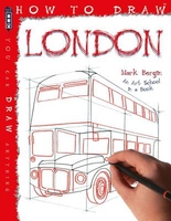
£12.99
Edward Rutherfurd’s London is an epic fictional account of the city’s history, a journey across sixteen centuries from the days of the Romans to the modern day Dockland redevelopment. The book is structured as a plethora of “short stories” which look at a specific period in London’s history, such as the building of the Tower of London, the Great Fire of London, Shakespeare & the original Globe Theatre, & the Blitz. The action is seen through generations of a clutch of central families; following the lives & adventures, & rivalries & hatreds of the colourful cast (which spans all aspects of the social class system) London’s past is truly brought to life. ...
Archived Product
£5.99
My London Infographic Sticker Activity Book is an interactive journey around the amazing city of London. Climb the tallest buildings, & head underground to learn facts & figures about the smelliest plant in the capital, building bridges over the river Thames & the number of bathrooms in Buckingham Palace. Packed with fact-based stickering, colouring & searching activities to help you remember all of the fascinating facts, My London Infographic Sticker Activity Book is a bold, bright & beautiful book that will take your imagination on an exciting journey.

Includes::
over 200 stickers & printed on high-quality paper that`s perfect to colour in with felt-tips or crayons, this book is ideal for long journeys, rainy days & a great gift for curious children.

...
Archived Product
£6.99
Take a trip to London! Lift the giant flaps to reveal what`s underneath, including lots of interesting textures! Feel the shiny London bus, stroke a furry monkey at London Zoo & touch a scaly dinosaur at the Natural History Museum! With something to spot or count on every spread too, this colourful book will provide lots of fun for older babies & toddlers. Part of the popular & well-established Campbell London series, Marion Billet`s bright & friendly illustrations really bring the London scenes to life, making them appealing to younger readers & perfectly complimenting the carefully chosen textured panels to touch. Also in the series: The London Noisy Tube, The London Noisy Bus, The London Noisy Book, My First London Bus, Hello! London, My Big London Play Set ...
Archived Product
£14.99
All you need to inspire every step of your trip. An in-depth book, now with free app & e Book. From deciding when to go, to choosing what to see when you arrive, this Insight Guides book is all you need to plan your trip & experience the best of London, with in-depth insider information on must-see, top attractions like Buckingham Palace, & hidden cultural gems like Hampstead Heath.· City Guide London is ideal for travellers seeking immersive cultural experiences, from exploring Piccadilly Circus to discovering Richmond· In-depth on history & culture: enjoy special features on Parliament & the blue plaques, all written by local experts·

Includes::
innovative extras that are unique in the market
- all City Guides come with a free e Book & app that`s regularly updated with new hotel, bar, restaurant, shop & local event listings· Invaluable maps, travel tips & practical information ensure effortless planning · Outstanding orientation information will save you time while you explore · Excellent Editor`s Choice recommendations will make your trip more memorable· Inspirational colour photography throughout· Inventive design makes for an engaging reading experience


...
Archived Product
£17.99
Back in 1985 the first ` British Railways Past & Present` was published, it has only taken 25 years for us to start the same treatment for Britain`s road transport scene. There is perhaps no better place to start than in the Capital City. London`s buses are well known throughout the world, being synonymous with the city. This volume takes us on a nostalgic tour of not just street scenes but also caomparative shots of the various bus related sites of the city. Bus stations & interchange points & garages & depots are slectively covered. The changes in the buses themselves & the advent in recent years of the return of the long lost street tramway make for fascinating reminders of both the past & the progress! This though is not just about the public service vehicles it is also about the cars, trucks, bikes & other motor vehicles that can be seen in the background. The fashions have also changed over the years while the buildings are remarkable either because they still stand or indeed because of what has replaced them after they have been swept aside in the passage of time. ...
Archived Product
£5.50
London street plan from the Touring Club Italiano with the publishers’ characteristic elegant cartography, printed on light, waterproof & tear-resistant synthetic paper, with a large, clear diagram of the Tf L network & a road map of Greater London. Current edition was published in summer 2014. Coverage extends from Hammersmith to beyond the Tower & from Swiss Cottage – Dalston to Clapham. Beautifully drawn cartography & colouring provide a very clear picture of main traffic arteries, important buildings & green spaces. Transport for London stations are annotated to differentiate between the Underground, Overground & Dockland lines & where appropriate locations different entrances/exits are marked. The map also indicates car parks & the boundary of the Congestion Zone. Street index is on the reverse, together with lists of useful contact numbers. Also provided is a separate index of the Transport of London stations. The map also

Includes::
a large diagram of the entire Transport for London network, plus a road map of Greater London.

...
Archived Product
£17.00
This guide is aimed at providing a useful instrument for understanding the architectural history of London as well as a means for analysing the new construction trends that are characteristic of the city. The itineraries include about eighty architectural works, both historical & contemporary, which are fully illustrated with images, drawings & descriptions, & are marked on the front of the map with a reference number corresponding to the section in the book & the icon on the back of the map. The guide also provides information about museums, libraries, institutions, movie theatres, restaurants & gathering places. Among others, the project selection

Includes::
works by Allies & Morrison, Arup Associates, Ateliers Jean Nouvel, Avery Associates, Foster + Partners, Grimshaw Architects, Herzog & De Meuron, James Stirling, Jestico + Whiles, John Mc Aslan + Partners, Stanton Williams, OMA, Renzo Piano Building Workshop, Richard Rogers Partnership, Stanton Williams Architects, Studio Daniel Libeskind, Wilkinson Eyre Architects, Zaha Hadid Architects.

...
Archived Product
£4.99
This new edition of Philip`s London & M25 Navigator Road Map features ultra-large-scale & detailed up-to-date Navigator mapping, ranging from Chatham in the east to Maidenhead in the west, & from Hemel Hempstead in the north to Gatwick Airport in the south. The map contains highly detailed coverage at 1.5 miles to 1 inch of the region`s road network, from motorways to minor country lanes & rural tracks
- & even major footpaths
- & every junction, roundabout & slip-road is shown in detail. There is much other detail, including hundreds of individually named farms, houses & hamlets. Also shown are airports, airfields, stations, ferries, canals, marinas & an abundance of places of interest. Opening out to 680 x 1200mm, Philip`s London & M25 Navigator Road Map has a comprehensive index &

Includes::
an indexed street plan of central London. Philip`s London & M25 Navigator Road Map is designed for both professional & leisure users. For professionals, the wealth of detail makes activities such as regional planning & delivery driving far easier. Also, the map is fully printed on one side (including the index) to allow hanging as a wall map. For leisure, the wealth of detail greatly eases the navigation of both main roads & byways, & increases the pleasure of touring by opening up new possibilities.


...
Archived Product
£9.99
The London & North Eastern Railway Map 1924: King`s Cross to Mallaig from The Old Book House presents the whole 605-mile long route divided into eights separate panels, printed side by side. All stations along the route are marked & annotated with distances from King’s Cross & to Mallaig. The map also shows tunnels & other railway lines connecting to or crossing the route, indicating sections closed since 1924. All along its course the route is annotated with comments on various features of the line & local sights, etc, including text describing changes since 1924. The map is presented in an elegant card envelope with an introductory essay providing more historical background on the London & North Eastern Railway. Please note: this title is also available as part of a four-map set with similar maps of the main routes from the GWR, SR & LM&SR companies. ...
Archived Product
£35.00
London & South East England Street Atlas at a scale of 1:25, 000 / 2.5 to a mile from the Automobile Association (AA) in an extra large/A4 paperback format. Coverage encompasses Central & Greater London, connecting areas of Essex, Suffolk, Buckinghamshire, Hertfordshire, Oxfordshire & Surrey, with the counties of Kent, East & West Sussex completely mapped & with coverage of Hampshire extending as far as Southampton & the surrounding area bordering on the New Forest National Park. With cartography sourced from Ordnance Survey data, the atlas is indexed by street & featured place & has National Grid references shown on the map frame of each page. Eighteen pages of enlarged Central London cartography is given at a scale of 1:10, 000 / 6.3 to a mile. in addition, enlargements of the following town centres are given at the same more detailed scale: Aldershot, Ashford, Aylesbury, Basildon, Basingstoke, Bognor Regis, Bracknell, Brighton, Canterbury, Chatham, Chelmsford, Chichester, Clacton-on-Sea, Colchester, Crawley, Croydon, Dover, Eastbourne, Fareham, Farnham, Felixstowe, Folkestone, Guilford, Harlow, Harwich, Hastings, Havant, Hemel Hempstead, High Wycombe, Horsham, Ipswich, Kingston Upon Thames, Lewes, Luton, Maidenhead, Maidstone, Margate, Milton Keynes, Newbury, Newhaven, Oxford, Portsmouth, Ramsgate, Reading, St Albans, Sevenoaks, Slough, Southampton, Southend-on-Sea, Stevenage, Tunbridge Wells, Watford, Winchester, Windsor, Woking, Wokingham & Worthing. Street by street road network is unambiguously presented, with motorways, major & minor roads easily distinguishable & colour coded, road names/numbers in bold type & pedestrian areas, one way streets, car parks, & major supplier petrol stations clearly locatable. Park & ride facilities are indicated, as are bus/coach stations, main & minor rail stations, level crossings & AA service centres, tramways, ferry routes & airport runways. London pages indicate the Congestion Charge boundaries &, where applicable, tracks & footpaths are mapped. Peak spot heights are given, mounds indicated & inland waterways shown, with aqueducts, locks & weirs in addition distinguished. The atlas legend contains a plethora of practical & visitor symbols including caravan & camping sites, AA recommended hotels, pubs, & restaurants, other places of leisure or cultural interest such as nature reserves, garden centres, historic houses & theatres/places of performance, abbeys/cathedrals/priories & natural trust properties, as well as useful information such as where to find public services & amenities such as toilets & hospitals. Somewhat randomly, AA has opted to include the location of IKEA stores. Current edition published 2005. PLEASE NOTE: due to the weight &

Dimensions of this product delivery is by UPS only.

...
Archived Product

London

This drawing handbook features top tips for drawing well-known London landmarks, including Buckingham Palace, St Paul`s Cathedral and Big Ben. It also introduces concepts such as light, tone, perspective and composition. With its clear step-by-step labelled drawings, this is an essential book for any budding artist who would like to master the art of drawing some of London`s best-loved landmarks and icons.
RIP - This product is no longer available on our network. It was last seen on 25.09.2019

This page now acts as a permanent archive for this product. Add more information using the comments box below to ensure it can still be found by future generations.

Use our search facility to see if it is available from an alternative contributor.
  • External links may include paid for promotion
  • Availability: Out Of Stock
  • Supplier: Stanfords
  • SKU: 9781909645127
Availability: In Stock
£5.99

Product Description

This drawing handbook features top tips for drawing well-known London landmarks, including Buckingham Palace, St Paul`s Cathedral & Big Ben. It also introduces concepts such as light, tone, perspective & composition. With its clear step-by-step labelled drawings, this is an essential book for any budding artist who would like to master the art of drawing some of London`s best-loved landmarks & icons.

Reviews/Comments

Add New

Intelligent Comparison

Oooops!
We couldn't find anything!
Perhaps this product's unique.... Or perhaps we are still looking for comparisons!
Click to bump this page and we'll hurry up.

Price History

Vouchers

No voucher codes found.
Do you know a voucher code for this product or supplier? Add it to Insights for others to use.

Facebook

Jargon Buster

Composition - A way in which something is made up.

Supplier Information

Stanfords
Stanfords was established in 1853 and opened their iconic Covent Garden flagship store in 1901. They have become the top retailer of maps, travel books and accessories in the UK and arguably offer the largest selection of maps and travel books worldwide. Famous names such as Captain Robert Falcon Scott, Ranulph Fiennes and Michael Palin have purchased from Stanfords. They now have a shop in Bristol and both stores together with other venues operate a calendar of events including talks, book signings and exhibitions. As a specialist map retailer, the map selection is comprehensive and includes road maps, street maps and walking maps from worldwide destinations, as well as a selection of world atlases and wall maps. Books include travel guides and travel literature. Stanfords also stock globes, from miniatures made of blue marble to magnificent floor-standing globes. The website features a selection of interesting articles on travel topics.
Page Updated: 2023-11-12 20:15:36

Community Generated Product Tags

Oh No! The productWIKI community hasn't generated any tags for this product yet!
Menu