
 United Kingdom
 France
 Germany
 Netherlands
 Sweden
 USA
USA
 Italy
Italy
 Spain
Spain
More From Contributor


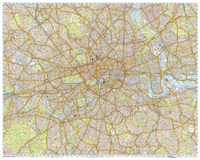
London Knowledge A-Z Wall Map LARGE LAMINATED 2-Sheets
Measuring 200x150cm *(made up two separate laminated sheets, each at 100x150cm)*, this is the enlarged version of A to Z’s London Knowledge map at 1:12, 770, covering an area extending at six miles from Charing Cross, reaching to Hornsey, Plaistow, Streatham and Chiswick. Road detail includes junction names, house numbers (on A and B roads), restricted routes, one-way streets, congestion charge zone, as well as safety camera locations with their maximum speed limit marked. Railways, railway stations and underground stations are marked, and colours distinguish sites of interest and various other buildings, such as industrial, shopping, public buildings, and schools. Other detail includes car parks, information offices, emergency services, hospitals, post offices and
public toilets. Local authority boundaries are marked and postcode areas are identified.*This map is also available with each sheet on durable foamboard.*
public toilets. Local authority boundaries are marked and postcode areas are identified.*This map is also available with each sheet on durable foamboard.*

Product Description
Reviews/Comments
Add New
Vouchers
No voucher codes found.
Do you know a voucher code for this product or supplier? Add it to Insights for others to use.
Do you know a voucher code for this product or supplier? Add it to Insights for others to use.
 Denmark