More From Contributor
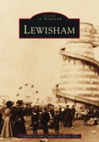
£14.95
Two centuries after their expedition awoke the nation both to the promise & to the disquiet of the vast territory out west, Lewis & Clark still stir the imagination, & their adventure remains one of the most celebrated & studied chapters in American history. This volume explores the legacy of Lewis & Clark`s momentous journey &, on the occasion of its bicentennial, considers the impact of their westward expedition on American culture. Approaching their subject from many different perspectives--literature, history, women`s studies, law, medicine, & environmental history, among others--the authors chart shifting attitudes about the explorers & their journals, together creating a compelling, finely detailed picture of the ”interdisciplinary intrigue” that has always surrounded Lewis & Clark`s accomplishment. This collection is most remarkable for its insights into ongoing debates over the relationships between settler culture & aboriginal peoples, law & land tenure, manifest destiny & westward expansion, as well as over the character of Sacagawea, the expedition`s vision of nature, & the interpretation & preservation of the Lewis & Clark Trail. ...
Archived Product
£34.95
Lewis & Harris Postcode Sector Map at 1:150, 000, encapsulated version, in a series of postcode sector maps showing the first part of the postcode & the first number of the second part, the Inward Code. Coverage extends north to Butt of Lewis, south to Tulm, east to Portnaguran, & west to Flannan Isles. Map Marketing’s series of postcode sector maps covers Great Britain & Northern Ireland on 36 titles, each available only as a flat map, either on paper or encapsulated for greater durability. Presentation

Includes::
postcode changes in the most recent Royal Mail Postcode updates. The series covers Great Britain at 1:150, 000 (1” to 2.4 miles), with Northern Ireland shown at 1:210, 000 & London at two scales: 1:60, 000 for the area within the M25 & in more detail at 1:15, 000 for central London. Postcode area, district & sector boundaries & numbers/letters are shown in red, with County & Unitary Authority boundaries in green. The map base shows motorways, primary, ‘A’ & down to unclassified roads, with conurbation shapes & city plan insets showing street level detail for major cities. To see the list of all the titles in this series please click on the series link.LAMINATED & ENCAPSULATED WALL MAPS:- LAMINATED wall maps have a thin layer of plastic usually applied to the printed side only. They can be written on with suitable marker pens without any damage to the map but, unless laminated on both sides, they are not damp-proof.- ENCAPSULATED wall maps are sealed between two sheets of plastic. They are more rigid & heavier than laminated maps of the same size. They are damp-proof & do not crinkle in humid conditions. Encapsulation gives the map a shiny surface, similar to being displayed behind glass.- PLEASE NOTE: many publishers & retailers often use these two terms interchangeably. Our map titles & descriptions follow the definitions provided above.

...
Archived Product
£24.95
Lewis & Harris Postcode Sector Map at 1:150, 000, paper version, in a series of postcode sector maps showing the first part of the postcode & the first number of the second part, the Inward Code. Coverage extends north to Butt of Lewis, south to Tulm, east to Portnaguran, & west to Flannan Isles. Map Marketing’s series of postcode sector maps covers Great Britain & Northern Ireland on 36 titles, each available only as a flat map, either on paper or encapsulated for greater durability. Presentation

Includes::
postcode changes in the most recent Royal Mail Postcode updates. The series covers Great Britain at 1:150, 000 (1” to 2.4 miles), with Northern Ireland shown at 1:210, 000 & London at two scales: 1:60, 000 for the area within the M25 & in more detail at 1:15, 000 for central London. Postcode area, district & sector boundaries & numbers/letters are shown in red, with County & Unitary Authority boundaries in green. The map base shows motorways, primary, ‘A’ & down to unclassified roads, with conurbation shapes & city plan insets showing street level detail for major cities. To see the list of all the titles in this series please click on the series link.

...
Archived Product
£8.99
` The future is not always a whole new ball game. There tends to be unfinished business. One trails all sorts of things around with one, things that simply won`t be got rid of.` Destined to be a haunter of libraries, Lewis`s cautious progress through life reveals to him only his own shortcomings. Estranged from his wife & daughter, he searches for an alternative. This novel presents the life & aspirations of one man who remains out of step with his times. ...
Archived Product
£239.99
Simply elegant, the Lewis Globe is a stunning 40cm (16) raised relief political globe cradled in a champagne-toned full meridian ...
Archived Product
£3.50
Lewisham in 1863-1867 in a fascinating series of reproductions of old Ordnance Survey plans in the Alan Godfrey Editions, ideal for anyone interested in the history of their neighbourhood or family. Three versions have been published for this area, stretching from Algernon Road & Ladywell station eastward to Lee Road & Burnt Ash Road, & from Lewisham Bridge & Belmont Hill southward to Hither Green station; the maps therefore really cover the centre & south of Lewisham town (not the station) & much of Lee. Features include Ladywell, High Street, High Road, Lee Green, Lewisham Park, workhouse, St Stephen`s Lewisham, St Mark`s, St Swithin`s, The Good Shepherd Handen Road, Holy Trinity Lee, Christ Church Lee, Lee Park, Wantage Road, Blessington Road, Brookbank Road, Hither Green Lane, etc. All three maps have extracts from contemporary street directories. About the Alan Godfrey Editions of the 25” OS Series: Selected towns in Great Britain & Ireland are covered by maps showing the extent of urban development in the last decades of the 19th & early 20th century. The plans have been taken from the Ordnance Survey mapping & reprinted at about 15 inches to one mile (1:4, 340). On the reverse most maps have historical notes & many also include extracts from contemporary directories. Most maps cover about one mile (1.6kms) north/south, one & a half miles (2.4kms) across; adjoining sheets can be combined to provide wider coverage.FOR MORE INFORMATION & A COMPLETE LIST OF ALL AVAILABLE TITLES PLEASE CLICK ON THE SERIES LINK. ...
Archived Product
£3.50
Lewisham in 1894 in a fascinating series of reproductions of old Ordnance Survey plans in the Alan Godfrey Editions, ideal for anyone interested in the history of their neighbourhood or family. Three versions have been published for this area, stretching from Algernon Road & Ladywell station eastward to Lee Road & Burnt Ash Road, & from Lewisham Bridge & Belmont Hill southward to Hither Green station; the maps therefore really cover the centre & south of Lewisham town (not the station) & much of Lee. Features include Ladywell, High Street, High Road, Lee Green, Lewisham Park, workhouse, St Stephen`s Lewisham, St Mark`s, St Swithin`s, The Good Shepherd Handen Road, Holy Trinity Lee, Christ Church Lee, Lee Park, Wantage Road, Blessington Road, Brookbank Road, Hither Green Lane, etc. All three maps have extracts from contemporary street directories. About the Alan Godfrey Editions of the 25” OS Series: Selected towns in Great Britain & Ireland are covered by maps showing the extent of urban development in the last decades of the 19th & early 20th century. The plans have been taken from the Ordnance Survey mapping & reprinted at about 15 inches to one mile (1:4, 340). On the reverse most maps have historical notes & many also include extracts from contemporary directories. Most maps cover about one mile (1.6kms) north/south, one & a half miles (2.4kms) across; adjoining sheets can be combined to provide wider coverage.FOR MORE INFORMATION & A COMPLETE LIST OF ALL AVAILABLE TITLES PLEASE CLICK ON THE SERIES LINK. ...
Archived Product
£3.50
Lewisham in 1914 in a fascinating series of reproductions of old Ordnance Survey plans in the Alan Godfrey Editions, ideal for anyone interested in the history of their neighbourhood or family. Three versions have been published for this area, stretching from Algernon Road & Ladywell station eastward to Lee Road & Burnt Ash Road, & from Lewisham Bridge & Belmont Hill southward to Hither Green station; the maps therefore really cover the centre & south of Lewisham town (not the station) & much of Lee. Features include Ladywell, High Street, High Road, Lee Green, Lewisham Park, workhouse, St Stephen`s Lewisham, St Mark`s, St Swithin`s, The Good Shepherd Handen Road, Holy Trinity Lee, Christ Church Lee, Lee Park, Wantage Road, Blessington Road, Brookbank Road, Hither Green Lane, etc. All three maps have extracts from contemporary street directories. About the Alan Godfrey Editions of the 25” OS Series: Selected towns in Great Britain & Ireland are covered by maps showing the extent of urban development in the last decades of the 19th & early 20th century. The plans have been taken from the Ordnance Survey mapping & reprinted at about 15 inches to one mile (1:4, 340). On the reverse most maps have historical notes & many also include extracts from contemporary directories. Most maps cover about one mile (1.6kms) north/south, one & a half miles (2.4kms) across; adjoining sheets can be combined to provide wider coverage.FOR MORE INFORMATION & A COMPLETE LIST OF ALL AVAILABLE TITLES PLEASE CLICK ON THE SERIES LINK. ...
Archived Product
£9.99
Map No. 789, George Washington & Jefferson National Forest: Lexington
- Blue Ridge, VA, in an extensive series of GPS compatible,
...
Archived Product
£6.50
Lexington & its Vicinity, in Kentucky, on an indexed street plan from Rand Mc Nally in their extensive range of maps covering cities in the United States. Communities included on the map are Danville, Frankfort, Georgetown, Harrodsburg, Lawrenceburg, Nicholasville, Paris, Richmond, Versailles & Winchester. Rand Mc Nally street plans provide coverage of cities with their outer suburbs, clearly indicating main traffic arteries: highways (distinguishing between free & toll access), plus primary & secondary routes. Road numbers and/or names are clearly displayed & exit numbers are indicated. Locations of service & rest areas are marked & one way streets are shown. Longer streets are annotated with block numbers for easier identification of addresses. The maps show railway, bus &, where appropriate, metro stations. A range of symbols indicate various places of interest including cultural & academic institutions, various municipal facilities, golf courses, etc. The plans have extensive street indexes, supplemented by lists of points of interest, parks & recreational areas, shopping malls, stations, schools, etc.A mileages & driving times map of the area is provided. ...
Archived Product

Lewisham

During the years between 1890 and 1930 Lewisham was a byword for solid comfort and respectability. However, this was a time of rapid change, when the wealthy merchants who had dominated Victorian Lewisham were moving further from their workplaces in london, and the streets were being colonised by thousands of lower middle class settlers. The commercial clerk was the characteristic denizen of early twentieth-century Lewisham. These new inhabitants were great lovers of postcards, and most of the pictures presented here, more than two hundred in total, and taken from the huge number of them published during that classic period. Very few have appeared in book form before. There are photographs of Blackheath (both the Lewisham and Greenwich parts), Lee, central Lewisham, Hither Green,
Ladywell, Crofton Park, Catford, Bellingham, Southend Village, and Grove Park. Most of the sections can form the basis for an interesting historical and architectural walk. But hurry! One of the old Lewisham buildinhs illustrated here has probably been demolished while you have been reading this!
RIP - This product is no longer available on our network. It was last seen on 25.09.2019

This page now acts as a permanent archive for this product. Add more information using the comments box below to ensure it can still be found by future generations.

Use our search facility to see if it is available from an alternative contributor.
  • External links may include paid for promotion
  • Availability: Out Of Stock
  • Supplier: Stanfords
  • SKU: 9780752400594
Availability: In Stock
£12.99

Product Description

During the years between 1890 & 1930 Lewisham was a byword for solid comfort & respectability. However, this was a time of rapid change, when the wealthy merchants who had dominated Victorian Lewisham were moving further from their workplaces in london, & the streets were being colonised by thousands of lower middle class settlers. The commercial clerk was the characteristic denizen of early twentieth-century Lewisham. These new inhabitants were great lovers of postcards, & most of the pictures presented here, more than two hundred in total, & taken from the huge number of them published during that classic period. Very few have appeared in book form before. There are photographs of Blackheath (both the Lewisham & Greenwich parts), Lee, central Lewisham, Hither Green, Ladywell, Crofton Park, Catford, Bellingham, Southend Village, & Grove Park. Most of the sections can form the basis for an interesting historical & architectural walk. But hurry! One of the old Lewisham buildinhs illustrated here has probably been demolished while you have been reading this!

Reviews/Comments

Add New

Intelligent Comparison

Oooops!
We couldn't find anything!
Perhaps this product's unique.... Or perhaps we are still looking for comparisons!
Click to bump this page and we'll hurry up.

Price History

Vouchers

No voucher codes found.
Do you know a voucher code for this product or supplier? Add it to Insights for others to use.

Facebook

Jargon Buster

Comfort - something that feels nice to the user. Often relaxing.
Greenwich - A southern borough in London.
Classic - Something that is still like it was originally a high quality standard.
Solid - Something that is firm and not liquid, a hard shape that cannot be changed easily.

Supplier Information

Stanfords
Stanfords was established in 1853 and opened their iconic Covent Garden flagship store in 1901. They have become the top retailer of maps, travel books and accessories in the UK and arguably offer the largest selection of maps and travel books worldwide. Famous names such as Captain Robert Falcon Scott, Ranulph Fiennes and Michael Palin have purchased from Stanfords. They now have a shop in Bristol and both stores together with other venues operate a calendar of events including talks, book signings and exhibitions. As a specialist map retailer, the map selection is comprehensive and includes road maps, street maps and walking maps from worldwide destinations, as well as a selection of world atlases and wall maps. Books include travel guides and travel literature. Stanfords also stock globes, from miniatures made of blue marble to magnificent floor-standing globes. The website features a selection of interesting articles on travel topics.
Page Updated: 2023-11-12 20:15:36

Community Generated Product Tags

Oh No! The productWIKI community hasn't generated any tags for this product yet!
Menu