More From Contributor

£12.99
In this paperback of his acclaimed & wide-ranging study, David Scott challenges traditional assumptions about how Britain achieved her global might. Shortlisted for the Duke of Westminster Medal for Military Literature 2013 Navigating the 300 years between the Tudor accession & the loss of the American colonies Leviathan charts one of history`s greatest transformations: the rise of Britain as the world`s most formidable maritime power. From the chaos of the Wars of the Roses, Henry VIII`s split with Rome & Oliver Cromwell`s Parliamentary regime, David Scott`s masterly narrative explodes traditional assumptions to present a much darker interpretation of this extraordinary story. Powered by a rapidly growing navy, a rapacious merchant marine, resilient politics, bigotry & religious fanaticism, warmongering & slavery, this candid book is required reading for all those wishing to understand how Britain achieved her global might. ...
Archived Product
£10.99
Levico
- Altopiani di Folgaria Lavarone e Luserna area in a series of Tabacco maps at 1:25, 000 covering the Dolomites & the mountains
...
Archived Product
£3.50
Lewes in 1898 in a fascinating series of reproductions of old Ordnance Survey plans in the Alan Godfrey Editions, ideal for anyone interested in the history of their neighbourhood or family. The map covers most of the town centre & extends southward across the marshes to Southerham Farm & Southerham Junction, & eastward across the River Ouse towards the Downs. In the north the map reaches Pelham Terrace, & in the west St Peter`s Place. Features include High Street, School Hill, North Street, the castle, Cliffe High Street, Malling Street, South Malling Brewery, Southdown Brewery, South Street, Phoenix Iron Works, St Thomas a Becket church, All Saints church, St John`s church, remains of St Pancras priory, station, & complex of railway junctions. On the reverse are extracts from the directory of 1905 listing private residents. About the Alan Godfrey Editions of the 25” OS Series Selected towns in Great Britain & Ireland are covered by maps showing the extent of urban development in the last decades of the 19th & early 20th century. The plans have been taken from the Ordnance Survey mapping & reprinted at about 15 inches to one mile (1:4, 340). On the reverse most maps have historical notes & many also include extracts from contemporary directories. Most maps cover about one mile (1.6kms) north/south, one & a half miles (2.4kms) across; adjoining sheets can be combined to provide wider coverage.FOR MORE INFORMATION & A COMPLETE LIST OF ALL AVAILABLE TITLES PLEASE CLICK ON THE SERIES LINK. ...
Archived Product
£3.50
Lewes & District in 1894 in a series of reproductions of Ordnance Survey’s famous ” Inch to the Mile” maps published in the Alan Godfrey Editions to provide a historical record of England & Wales in the second half of 19th & early 20th century. Coverage stretches from Lewes eastward to Pevensey & Wartling, & from Alfriston northward to Uckfield. Features include the towns of Lewes & Hailsham, the Lewes & Uckfield railway, Hailsham Branch, etc. Other locations in Sussex include Akciston, Arlington, Barcombe, Beddingham, Berwick, Chailey, Chalvington, Chiddingley, Dallington, East Hoathly, Folkington, Framfield, Glynde, Heathfield, Hellingly, Herstmonceux, Iford, Isfield, Kingston, Laughton, Little Horsted, Lullington, Newick, Piddinghoe, Ringmer, Ripe, Rodmell, Selmeston, South Heighton, Southease, Telscombe, Waldron, Warbleton, West Firle, Westham & Wilmington. On the reverse is a detailed map of Westham including Pevensey Castle. About the Alan Godfrey Editions of the OS Inch to the Mile Maps: the maps provide an invaluable overview of a wider area, typically 18 x 12 miles (29 x 19 kms approx.), & offer historical mapping for small towns & villages not covered by the more detailed series for which the Godfrey Editions are better known. On the reverse all the maps have historical notes & most titles also include a more detailed, large scale map of a small town or a village in the area. To see other titles in this series please click on the series link. ...
Archived Product
£20.00
On 14 May 1804 Meriwether Lewis & William Clark set out from Cape Dubois near St Louis with nearly four dozen man & headed west on the Missouri River. Sent by their scientist
- President Thomas Jefferson, they were embarking on the nation`s first exploration into unknown places, the most important expedition in American history. They called themselves the Corps of Discovery, yet they would fail to discover the primary object of their mission
- the Northwest passage
- a mythical all-river route through the mountains. Instead, their real discovery would be the land itself
- & the promises it held. This magnificent book, written by Dayton Duncan
- with contributions from Ken Burns, Stephen Ambrose & Erica Funkhouser
- is illustrated with the full spectrum of animals, plants, landscapes, people & entire cultures which had never previously been seen by `civilized` men. It also draws on the journals kept by Lewis & Clark & by others in the Corps: reports of their encounters with indians; loving descriptions of the Western landscape; introductions to two of the most fascinating characters in the party, the Shoshone woman Sacagawea & Clark`s slave York; intense accounts of hunger, numbing cold, loneliness, excitement & much more.


...
Archived Product
£9.99
About this series: Ideal companions for any visitor to Scotland`s islands. Each guide

Includes::
a number of

...
Archived Product
£14.95
Two centuries after their expedition awoke the nation both to the promise & to the disquiet of the vast territory out west, Lewis & Clark still stir the imagination, & their adventure remains one of the most celebrated & studied chapters in American history. This volume explores the legacy of Lewis & Clark`s momentous journey &, on the occasion of its bicentennial, considers the impact of their westward expedition on American culture. Approaching their subject from many different perspectives--literature, history, women`s studies, law, medicine, & environmental history, among others--the authors chart shifting attitudes about the explorers & their journals, together creating a compelling, finely detailed picture of the ”interdisciplinary intrigue” that has always surrounded Lewis & Clark`s accomplishment. This collection is most remarkable for its insights into ongoing debates over the relationships between settler culture & aboriginal peoples, law & land tenure, manifest destiny & westward expansion, as well as over the character of Sacagawea, the expedition`s vision of nature, & the interpretation & preservation of the Lewis & Clark Trail. ...
Archived Product
£34.95
Lewis & Harris Postcode Sector Map at 1:150, 000, encapsulated version, in a series of postcode sector maps showing the first part of the postcode & the first number of the second part, the Inward Code. Coverage extends north to Butt of Lewis, south to Tulm, east to Portnaguran, & west to Flannan Isles. Map Marketing’s series of postcode sector maps covers Great Britain & Northern Ireland on 36 titles, each available only as a flat map, either on paper or encapsulated for greater durability. Presentation

Includes::
postcode changes in the most recent Royal Mail Postcode updates. The series covers Great Britain at 1:150, 000 (1” to 2.4 miles), with Northern Ireland shown at 1:210, 000 & London at two scales: 1:60, 000 for the area within the M25 & in more detail at 1:15, 000 for central London. Postcode area, district & sector boundaries & numbers/letters are shown in red, with County & Unitary Authority boundaries in green. The map base shows motorways, primary, ‘A’ & down to unclassified roads, with conurbation shapes & city plan insets showing street level detail for major cities. To see the list of all the titles in this series please click on the series link.LAMINATED & ENCAPSULATED WALL MAPS:- LAMINATED wall maps have a thin layer of plastic usually applied to the printed side only. They can be written on with suitable marker pens without any damage to the map but, unless laminated on both sides, they are not damp-proof.- ENCAPSULATED wall maps are sealed between two sheets of plastic. They are more rigid & heavier than laminated maps of the same size. They are damp-proof & do not crinkle in humid conditions. Encapsulation gives the map a shiny surface, similar to being displayed behind glass.- PLEASE NOTE: many publishers & retailers often use these two terms interchangeably. Our map titles & descriptions follow the definitions provided above.

...
Archived Product
£24.95
Lewis & Harris Postcode Sector Map at 1:150, 000, paper version, in a series of postcode sector maps showing the first part of the postcode & the first number of the second part, the Inward Code. Coverage extends north to Butt of Lewis, south to Tulm, east to Portnaguran, & west to Flannan Isles. Map Marketing’s series of postcode sector maps covers Great Britain & Northern Ireland on 36 titles, each available only as a flat map, either on paper or encapsulated for greater durability. Presentation

Includes::
postcode changes in the most recent Royal Mail Postcode updates. The series covers Great Britain at 1:150, 000 (1” to 2.4 miles), with Northern Ireland shown at 1:210, 000 & London at two scales: 1:60, 000 for the area within the M25 & in more detail at 1:15, 000 for central London. Postcode area, district & sector boundaries & numbers/letters are shown in red, with County & Unitary Authority boundaries in green. The map base shows motorways, primary, ‘A’ & down to unclassified roads, with conurbation shapes & city plan insets showing street level detail for major cities. To see the list of all the titles in this series please click on the series link.

...
Archived Product
£8.99
` The future is not always a whole new ball game. There tends to be unfinished business. One trails all sorts of things around with one, things that simply won`t be got rid of.` Destined to be a haunter of libraries, Lewis`s cautious progress through life reveals to him only his own shortcomings. Estranged from his wife & daughter, he searches for an alternative. This novel presents the life & aspirations of one man who remains out of step with his times. ...
Archived Product

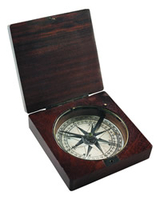
Lewis & Clark Compass

The original compass used by Clark is on display at the Smithsonian and is handsomely reproduced here. Made from glass and lightly distressed rosewood with a beautiful rustic bronze trim. A needle pointing north. Antique science captured in admiralty brass. Allowing sailors to cross vast oceans, explorers to discover continents. An instrument of exploration that changed the world of Renaissance forever.If we do not have this item in stock we will order it for you from our supplier. Delivery generally takes 3 weeks within the UK. For overseas delivery queries please email sales@stanfords.co.uk
RIP - This product is no longer available on our network. It was last seen on 25.09.2019

This page now acts as a permanent archive for this product. Add more information using the comments box below to ensure it can still be found by future generations.

Use our search facility to see if it is available from an alternative contributor.
  • External links may include paid for promotion
  • Availability: Out Of Stock
  • Supplier: Stanfords
  • SKU: 0781934566250
Availability: In Stock
£29.99

Product Description

The original compass used by Clark is on display at the Smithsonian & is handsomely reproduced here. Made from glass & lightly distressed rosewood with a beautiful rustic bronze trim. A needle pointing north. Antique science captured in admiralty brass. Allowing sailors to cross vast oceans, explorers to discover continents. An instrument of exploration that changed the world of Renaissance forever. If we do not have this item in stock we will order it for you from our supplier. Delivery generally takes 3 weeks within the UK. For overseas delivery queries please email sales@stanfords.co.uk

Reviews/Comments

Add New

Intelligent Comparison

Oooops!
We couldn't find anything!
Perhaps this product's unique.... Or perhaps we are still looking for comparisons!
Click to bump this page and we'll hurry up.

Price History

Vouchers

No voucher codes found.
Do you know a voucher code for this product or supplier? Add it to Insights for others to use.

Facebook

Jargon Buster

Brass - A copper and Zinc Alloy
UK - United Kingdom - An island nation in Europe
Glass - A solid, typically transparent. Brittle and used in windows. The first patent granted in the UK was for Glass.
antique - An old collectible item with desirable qualities.
email - An electronic communication method. Short for Electronic Mail.
delivery - The method by which something is delivered from one location to another
World - A physical grouping, commonly used to describe earth and everything associated with ti
Rustic - An obect which has not been finely finished leaving a natural finish, often unique
Instrument - A wide range of meanings from musical instrument to a measuring instrument

Supplier Information

Stanfords
Stanfords was established in 1853 and opened their iconic Covent Garden flagship store in 1901. They have become the top retailer of maps, travel books and accessories in the UK and arguably offer the largest selection of maps and travel books worldwide. Famous names such as Captain Robert Falcon Scott, Ranulph Fiennes and Michael Palin have purchased from Stanfords. They now have a shop in Bristol and both stores together with other venues operate a calendar of events including talks, book signings and exhibitions. As a specialist map retailer, the map selection is comprehensive and includes road maps, street maps and walking maps from worldwide destinations, as well as a selection of world atlases and wall maps. Books include travel guides and travel literature. Stanfords also stock globes, from miniatures made of blue marble to magnificent floor-standing globes. The website features a selection of interesting articles on travel topics.
Page Updated: 2023-11-12 20:15:36

Community Generated Product Tags

Oh No! The productWIKI community hasn't generated any tags for this product yet!
Menu