
 United Kingdom
 France
 Germany
 Netherlands
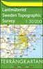
 Sweden
 USA
USA
 Italy
Italy
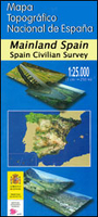
 Spain
Spain
More From Contributor


Lepe CNIG Topographic Map 998-II
Topographic coverage of mainland Spain at 1:25, 000 published by the Centro Nacional de Información Geograficá, the country’s civilian survey organization. The maps have contours at 10m intervals and colouring and/or graphics to show different types of vegetation or land use. Boundaries of national parks and other protected areas are marked. In addition to all the usual information shown on topographic maps at this scale, detailed presentation of the road and rail networks, rural tracks and paths, etc, the maps also show campsites. The maps have a 1-km UTM grid, with margin ticks for latitude and longitude at 1` intervals. Map legend is in Spanish only.PLEASE NOTE: our grid for the whole of Spain is in preparation - in the meantime, for areas other than those shown on the
attached grid please use CNIG’s topographic survey at 1:50, 000 by searching for ‘SI00000832’. Each 25K map covers one quarter of the corresponding 50K map, with the numbering system: I = NW quarter, II = NE quarter, III = SW quarter and IV = SE quarter. CNIG maps in the Provincial Road Maps series at 1:200, 000 are overprinted with the grid for the 1:50, 000 survey and can be used to see the area covered by each 50K or 25K title in more detail. To see the list of titles in this series please click on the series grid - for map numbers not yet listed on our website please contact us by email.
attached grid please use CNIG’s topographic survey at 1:50, 000 by searching for ‘SI00000832’. Each 25K map covers one quarter of the corresponding 50K map, with the numbering system: I = NW quarter, II = NE quarter, III = SW quarter and IV = SE quarter. CNIG maps in the Provincial Road Maps series at 1:200, 000 are overprinted with the grid for the 1:50, 000 survey and can be used to see the area covered by each 50K or 25K title in more detail. To see the list of titles in this series please click on the series grid - for map numbers not yet listed on our website please contact us by email.

Product Description
Reviews/Comments
Add New
Vouchers
No voucher codes found.
Do you know a voucher code for this product or supplier? Add it to Insights for others to use.
Do you know a voucher code for this product or supplier? Add it to Insights for others to use.
 Denmark