
 United Kingdom
 France
 Germany
 Netherlands
 Sweden
 USA
USA
 Italy
Italy
 Spain
Spain
More From Contributor


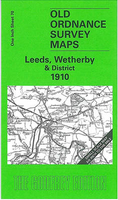
Leeds, Wetherby And District 1910
Leeds, Wetherby and District in 1910 in a series of reproductions of Ordnance Survey’s famous ”Inch to the Mile” maps published in the Alan Godfrey Editions to provide a historical record of England and Wales in the second half of 19th and early 20th century.The map covers the area from Kirkstall, Headingley and Leeds eastward to Church Fenton, and northward to Wetherby and Spofforth. Other locations covered include Angram, Arthington, Askham Richard, Barkston, Barwick in Elmet, Bickerton, Biggin, Bilbrough, Bilton, Bolton Percy, Boston Spa, Castley, Catterton, Clifford, Collingham, Colton, Dunkeswick, East Keswick, Garforth, Harewood, Healaugh, Hutton Wandesley, Kirk Deighton, Kirby Overblow, Lead, Linton, Little Fenton, Long Marston, Newthorpe,
Oxton, Rigton, Roundhay, Scarcroft, Seacroft, Shadwell, Sherburn in Elmet, Sicklinghall, Tadcaster, Thorner, Thorp Arch, Towton, Ulleskelf, Walton, Weardley, Weeton, Wighill, and Wike. On the reverse is a detailed map of Aberford. About the Alan Godfrey Editions of the OS Inch to the Mile Maps: the maps provide an invaluable overview of a wider area, typically 18 x 12 miles (29 x 19 kms approx.), and offer historical mapping for small towns and villages not covered by the more detailed series for which the Godfrey Editions are better known. On the reverse all the maps have historical notes and most titles also include a more detailed, large scale map of a small town or a village in the area.To see other titles in this series please click on the series link.
Oxton, Rigton, Roundhay, Scarcroft, Seacroft, Shadwell, Sherburn in Elmet, Sicklinghall, Tadcaster, Thorner, Thorp Arch, Towton, Ulleskelf, Walton, Weardley, Weeton, Wighill, and Wike. On the reverse is a detailed map of Aberford. About the Alan Godfrey Editions of the OS Inch to the Mile Maps: the maps provide an invaluable overview of a wider area, typically 18 x 12 miles (29 x 19 kms approx.), and offer historical mapping for small towns and villages not covered by the more detailed series for which the Godfrey Editions are better known. On the reverse all the maps have historical notes and most titles also include a more detailed, large scale map of a small town or a village in the area.To see other titles in this series please click on the series link.

Product Description
Reviews/Comments
Add New
Vouchers
No voucher codes found.
Do you know a voucher code for this product or supplier? Add it to Insights for others to use.
Do you know a voucher code for this product or supplier? Add it to Insights for others to use.
 Denmark