More From Contributor
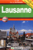
£11.19
Laminated waterproof edition of a detailed topographic map from the Ordnance Survey Explorer series, covering Roadford Lake. Edition B1; Publication date March 2006 About this series: These highly detailed maps show all the administrative boundaries, settlements as small as isolated farms, the road network down to unfenced roads & country tracks, & field boundaries (hedges & drystone walls) which make navigation across the countryside much easier. Steep gradients on roads are indicated. Various landmarks, e.g. powerlines, archaeological sites, windmills, churches & lighthouses are shown & additional graphics indicate natural terrain features such as cliffs, scree, mud & vegetation variations. The contour interval is 5 metres in the lower parts of the country & 10 metres in the uplands, & spot heights are marked. Each map covers an area of 30 x 20km (i.e. approx. 19 x 12 miles), with some double-sided maps covering more, as indicated in the individual descriptions. The maps are fully GPS compatible, with the National Grid shown at 1km intervals & latitude & longitude indicated by margin ticks at 1'. The Explorer series has replaced the earlier, green-cover Pathfinder maps. The Explorer series is now complete & covers all of Engl&, Wales & Scotl&. Some sheets for popular areas like the National Parks are still branded as Outdoor Leisure (OL) maps, but are now included in this series as the cartography is the same as that in the Explorer Maps. The Explorer maps offer a substantial improvement on the Pathfinder series, with greater use of colour, larger area per map, & stronger emphasis on information for ramblers & tourists. This series is ideal for walking & other outdoor pursuits & each map shows a large amount of information for ramblers & tourists. Public rights of way are shown (except in Scotland), together with other routes with public access: National Trails & Recreational Paths, permitted paths & bridleways, & selected cycle routes. Open access land created under the Countryside & Rights of Way Act 2000 is marked. Tourist information

Includes::
caravan & camp sites, Park & Ride locations, recreation/leisure/sport centres, museums, historic buildings, English Heritage & National Trust sites, rural pubs, etc. The map legend is in English only, except for the tourist information content which is also in French & German.

...
Archived Product
£35.00
Launching, operating & recovering small boats are activities outside the expertise of most crew & can require considerable skill & seamanship. For safety reasons, a practice drill is unlikely to provide a realistic simulation of an emergency situation. This book demonstrates good practice when carrying out these operations & explains the techniques & systems that can improve manoeuvres. It reviews the equipment available & assesses both its benefits & its potential drawbacks. ...
Archived Product
£2.99
This Laundry paper from Natural Products is compact, convenient & easy to use. Perfect when travelling for washing socks & all you have, the handy carry case contains 30 single use soap sheets that dissolve in water for washing your clothes on the go. What's more, Natural Products' laundry paper is suitable to carry on all airlines. ...
Archived Product
£8.99
In the doorway of an elegant New York apartment, blood seeps over silk negligee, over polished wood floors & plush carpet: a beautiful young woman lies dead, her face disfigured by a single gun shot. But who was Laura? What power did she hold over the very different men in her life? How does her portrait bewitch even Mark Mc Pherson, the hard-bitten detective assigned to find her murderer? One stormy night, Mark`s investigation takes an unexpected turn... ...
Archived Product
£20.00
Thousands of hours on the pedals, forever turning left, following that black line round, pushing your body harder than it is designed to go. Then comes the sacrifice. All familiar pleasures stripped away in search of perfection. Then the pain. Muscles burning, stomach churning, an ache in the bones. To pull all of this together to achieve an Olympic gold is impressive; to be part of a couple doing this in the same sport is rare; to do it ten times between you is unprecedented. Laura Trott & Jason Kenny, Britain`s most successful female & male Olympians, invite us into their world, on to the boards of the velodrome & down the back straight of British pro cycling to give us the inside track on what it takes to become a champion. This is the story of the races that gripped a nation; one of sprints & pursuits, tactics, mind games, medals & trials; of being so tired you collapse by the side of the track, so out of form you can`t finish a practice session; of what goes through the mind of an Olympian as they power towards the finish line; & of how a boy from Bolton & a girl from Cheshunt became the best in the world, while finding in each other the perfect partner. ...
Archived Product
£8.99
Indexed street plan with the same cartography & detail as its larger version, but covering a slightly smaller area. The plan indicates pedestrian areas within the city centre & shows public transport, car parks, museums, theatres, post offices, etc. Map legend

Includes::
English.

...
Archived Product
£20.99
Swiss topographic survey at 1:100, 000 from Swisstopo, highly regarded for it superb use of graphic relief & hill shading, ...
Archived Product
£19.99
Lausanne
- Lavaux area at 1:50, 000 in a series from Hallwag covering Switzerland’s popular hiking regions on light, waterproof
...
Archived Product
£19.99
Lausanne
- Vallée de Joux area at 1:60, 000 in Kümmerly + Frey’s hiking series of Switzerl&, with most titles now printed on
...
Archived Product
£19.99
Lausanne
- Vallée de Joux area at 1:60, 000 in Kümmerly + Frey’s series of cycling maps published in co-operation with the Association
...
Archived Product

Lausanne

One of two very similar maps of the city by this publisher, this one incorporating more symbols for particular features and landmarks.Indexed street map of the city with coverage extending Pully, Bois de la Chanaula, Villars-St-Croix & Denges. An inset map at 1:5, 000 shows the city centre. Railways are included in the detail, also metro lines, pedestrian zones, post offices, hospitals, information ofices, car parks & notable buildings. There is a diagram of the local public transport network, an overview map showing the major roads through the city, and a small road map at approx 1:300, 000 of the region around Lausanne.
RIP - This product is no longer available on our network. It was last seen on 25.09.2019

This page now acts as a permanent archive for this product. Add more information using the comments box below to ensure it can still be found by future generations.

Use our search facility to see if it is available from an alternative contributor.
  • External links may include paid for promotion
  • Availability: Out Of Stock
  • Supplier: Stanfords
  • SKU: 9783828306158
Availability: In Stock
£7.95

Product Description

One of two very similar maps of the city by this publisher, this one incorporating more symbols for particular features & landmarks. Indexed street map of the city with coverage extending Pully, Bois de la Chanaula, Villars-St-Croix & Denges. An inset map at 1:5, 000 shows the city centre. Railways are included in the detail, also metro lines, pedestrian zones, post offices, hospitals, information ofices, car parks & notable buildings. There is a diagram of the local public transport network, an overview map showing the major roads through the city, & a small road map at approx 1:300, 000 of the region around Lausanne.

Reviews/Comments

Add New

Price History

Vouchers

No voucher codes found.
Do you know a voucher code for this product or supplier? Add it to Insights for others to use.

Facebook

Jargon Buster

Railways - A set of tracks that have been laid for the purpose of trains to travel up and down them
Car - A machine used for transport which runs on roads
Network - A link and communication between things. Often computers or people.
Small - something that takes up less space than normal.
Road - a manmade lane or a path that is used to speed up travel.
Transport - Something that carries people or goods.

Supplier Information

Stanfords
Stanfords was established in 1853 and opened their iconic Covent Garden flagship store in 1901. They have become the top retailer of maps, travel books and accessories in the UK and arguably offer the largest selection of maps and travel books worldwide. Famous names such as Captain Robert Falcon Scott, Ranulph Fiennes and Michael Palin have purchased from Stanfords. They now have a shop in Bristol and both stores together with other venues operate a calendar of events including talks, book signings and exhibitions. As a specialist map retailer, the map selection is comprehensive and includes road maps, street maps and walking maps from worldwide destinations, as well as a selection of world atlases and wall maps. Books include travel guides and travel literature. Stanfords also stock globes, from miniatures made of blue marble to magnificent floor-standing globes. The website features a selection of interesting articles on travel topics.
Page Updated: 2023-11-12 20:15:36

Community Generated Product Tags

Oh No! The productWIKI community hasn't generated any tags for this product yet!
Menu