More From Contributor
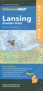
£6.95
Topographic coverage of mainland Spain at 1:50, 000 in the MTN50 (Mapa Topográfico Nacional) series from the Centro Nacional de Información Geografica, the country’s civilian survey organization. The maps have contours at 20m intervals, enhanced by relief shading, plus colouring and/or graphics to show different types of terrain, vegetation or land use. Boundaries of national parks & other protected areas are marked. In addition to all the usual information featured on topographic mapping at this scale, detailed presentation of the road & rail networks, rural tracks & paths, etc, the maps also show campsites & mountain refuges. On more recent editions some GRs, the official long-distance hiking routes, are also marked (although not as clearly as on hiking maps from other publishers). Each map covers 29.5x 18.5 km (with adjustments in the border or coastal areas). The maps have a 1-km UTM grid, plus margin ticks for latitude & longitude at 1` intervals. Map legend is in Spanish only.HOW TO CHOOSE THE RIGHT 50K MAP: all the titles in CNIG’s 200K Provincial Road Maps series at 1:200, 000 are overprinted with the grid for the 1:50, 000 maps & can be used to see the area covered by each 50K title. TO SEE THE LIST OF TITLES IN THIS SERIES PLEASE CLICK ON THE SERIES LINK.PLEASE NOTE
- MAP TITLES: the grids shown on our website serve both the civilian & the military 1:50, 000 topographic series. Although the areas covered by maps in both series are identical (apart from some border or coastal sheets), occasionally map titles differ – only one title is shown on the grid, usually the military one. In Galicia, the Basque country & in the Catalan speaking areas the tendency now is to use local place names rather than the often better known Castilian ones. Where possible, both versions are included in our titles. Map titles listed on our website are based on information received by us at the time of publication, but sometimes maps arrive showing a completely different title! As long as the map number is as ordered, the correct map has been supplied.
...
Archived Product
£6.50
Topographic coverage of mainland Spain at 1:25, 000 published by the Centro Nacional de Información Geograficá, the country’s civilian survey organization. The maps have contours at 10m intervals & colouring and/or graphics to show different types of vegetation or land use. Boundaries of national parks & other protected areas are marked. In addition to all the usual information shown on topographic maps at this scale, detailed presentation of the road & rail networks, rural tracks & paths, etc, the maps also show campsites. The maps have a 1-km UTM grid, with margin ticks for latitude & longitude at 1` intervals. Map legend is in Spanish only.PLEASE NOTE: our grid for the whole of Spain is in preparation
- in the meantime, for areas other than those shown on the attached grid please use CNIG’s topographic survey at 1:50, 000 by searching for ‘SI00000832’. Each 25K map covers one quarter of the corresponding 50K map, with the numbering system: I = NW quarter, II = NE quarter, III = SW quarter & IV = SE quarter. CNIG maps in the Provincial Road Maps series at 1:200, 000 are overprinted with the grid for the 1:50, 000 survey & can be used to see the area covered by each 50K or 25K title in more detail. To see the list of titles in this series please click on the series grid
- for map numbers not yet listed on our website please contact us by email.

...
Archived Product
£12.99
Topographic survey of France at 1:25, 000 in IGN`s excellent TOP25 / Série Bleue series. All the maps are GPS compatible, with a 1km UTM grid plus latitude & longitude lines at 5’ intervals. Contours are at 5m intervals except for mountainous areas where the maps have contours at 10m intervals, vividly enhanced by hill shading & graphics for rocky terrain. Colouring with graphics indicates different types of vegetation or land use (deciduous or coniferous forests, moors, orchards, vineyards, etc). PLEASE NOTE: coverage of France at this scale is currently being revised – the format & the presentation of each title are indicated by the letters at the end of its Sheet Reference number (e.g. 0416ET, 3531ETR, 1923SB, etc.)MAPS WITH FULL TOURIST OVERPRINT & AN ENGLISH MAP LEGEND: all TOP25 maps & the SB editions of Série Bleue have an overprint highlighting waymarked walking trails including long-distance GR routes &, where appropriate, ski routes. Symbols indicate campsites, gîtes d’etape, refuges, equestrian centres & other recreational facilities or sites, tourist information centres, cultural heritage, etc. Towns & locations of particular interest are highlighted.- ET or OT = single-sided TOP25 map covering approx. 29x 21 km / 18x 13 miles.- ETR or OTR = waterproof & tear resistant TOP25 map covering the same area as the corresponding ET or OT number, but double-sided, printed on a smaller size sheet with a good overlap between the sides.- SB = Série Bleue map with full tourist overprint; these maps, first introduced in summer 2014, each cover approx. 29x 24km / 18x 15 miles.SÉRIE BLEUE maps with numbers ending in E (Est) or O (Ouest): most editions now indicate the GR routes, but do not show any other tourist information. Map legend is in French only. Each map covers approx. 14x 20km / 9x 12 miles. ...
Archived Product
£9.99
Upper Langtang Valley, sheet no. 2885-15, in the topographic survey of Nepal at 1:50, 000 published by the Nepali Government in the late 1990s & early 2000s & produced from remote sensing data by Finnish cartographers as part of that country’s international aid program. The maps cover 15’ x 15’ quadrangles.IMPORTANT – PLEASE NOTE BEFORE ORDERING: AVAILABILITY: although, theoretically at least, still in print, these maps are very difficult to get locally in Nepal and/or from various suppliers elsewhere specializing in obtaining such maps. DELIVERIES MAY TAKE SEVERAL WEEKS OR EVEN MONTHS.PROBLEMS WITH PLACE NAMES: reports from previous users indicate that transliteration of place names differs from that used widely not only on other maps & in guide books but also on the ground itself, in road signs & in the tourist & trekking industry in general. Whilst most names are similar enough to be easily recognizable, e.g. Namche Bajar for Namche Bazar or Lantan for Langtang, we have been told of confusion & difficulties arising from different spellings appearing on these maps.TREKKING ROUTES & TOURIST INFORMATION: whilst the maps show foot trails & mark locations of temples, etc, they carry no specific trekking information. Major trekking routes & places of interest are not highlighted. There is no marking for base camps & other tourist facilities. Map specifications: Contours are at 40m intervals, with graphics and/or coloring to show various features of the terrain (glaciers with moraines & crevasses, quarries, gravel or clay pits, etc.) & vegetation (forests, bush, grass, orchards & plantations, etc). Additional comments such as “open mixed forest mainly bajh & pine” annotate many area. The maps have numerous spot heights, but relatively few peaks are named. Areas outside the country’s borders are left blank. Settlements in remote areas are indicated by markings for individual buildings & the placing of names does not always make it clear which group of buildings they refer to. Road network distinguishes between major & minor foot trails. Symbols mark features such as temples, schools & hospitals, police stations, etc. Also shown are the country’s administrative divisions. The maps have a 1-km UTM grid, plus latitude & longitude lines at intervals of 5’. Map legend & all the text is in English. Coverage: the whole country is now covered, with the north at 1:50, 000, plus central & southern Nepal at 1:25, 000. The two series are complementary, do not overlap & use the same grid & numbering system (apart from the Lumbini Zone, where a different grid & numbering are used). For areas not shown on our grid & titles not listed here, please contact us by e-mail, but please do bear in mind the problems with availability & the likely very long delivery time. ...
Archived Product
£9.99
” Food that inspires, delights & nourishes, food that really hits the spot
- this is [ Shelagh] Ryan`s culinary cause. She manages
...
Archived Product
£10.99
The competitor who finishes last in the Tour de France. The red lantern that hangs on the rear of a train. If you complete a bike race of over 3, 000 kilometres, overcoming mountain ranges & merciless weather conditions while enduring physical & psychological agony, in the slowest time, should you be branded the loser? What if your loss helped a teammate win? What if others lacked the determination to finish? What if you were trying to come last? Froome, Wiggins, Merckx
- we know the winners of the Tour de France, but Lanterne Rouge tells the forgotten, often inspirational & occasionally absurd stories of the last-placed rider. We learn of stage winners & former yellow jerseys who tasted life at the other end of the bunch; the breakaway leader who stopped for a bottle of wine & then took a wrong turn; the doper whose drug cocktail accidently slowed him down & the rider who was recognised as the most combative despite finishing at the back. Lanterne Rouge flips the Tour de France on its head & examines what these stories tell us about ourselves, the 99% who don`t win the trophy, & forces us to re-examine the meaning of success, failure & the very nature of sport.
...
Archived Product
£27.99
Eye to Eye, the first personal portfolio by master photographer Frans Lanting, presents an extraordinary collection of animal images by an award-winning photographer & naturalist who has set the standards for a whole generation of wildlife photographers. More than 140 photographs, made over a period of twenty years, reveal the unique personal aesthetic Frans Lanting brings to wildlife photography, as well as the startling new perspective on animals his images provoke. ...
Archived Product
£12.99
Lanzarote is the Sunflower Landscapes guide to exploring the best walking & touring possibilities on the isl&. The guide covers a range of routes including walks in La Graciosa, Maguez, Mancha Blamca, Yaiza & Lobos. A double-sided, fold-out touring map of Lanzarote gives an overview of the island & the locations of each walk. Detailed information about touring by hired car or public transport, as well as on foot, is provided, helping walkers to navigate & plan day-trips. Shorter strolls are also included as an alternative for each main route for those seeking more leisurely days out. The guide is structured in two main parts ...
Archived Product

Lansing, MI

Lansing in Michigan in a series of indexed street plans of US cities from UniversalMAP. On one side is a street plan of Lansing with insets providing coverage of St. Johns, Portland, Eaton Rapids, Perry, Charlotte, Mason and Wiliamston City and its vicinity. On the reverse is an indexed road map of the Lancing regional area, an enlargement showing downtown Lansing in greater detail, plus an indexed plan of the Michigan State University campus.Coverage includes also Bath, DeWitt, Dimondate, East Lansing, Grand Ledge, Haslett, Holt, Laingsburg, Okemos, Perry, Portland, Potterville and St. Johns, Street plans from UniversalMAP are indexed and show each city’s administrative divisions, zip code areas and various facilities and services.
RIP - This product is no longer available on our network. It was last seen on 25.09.2019

This page now acts as a permanent archive for this product. Add more information using the comments box below to ensure it can still be found by future generations.

Use our search facility to see if it is available from an alternative contributor.
  • External links may include paid for promotion
  • Availability: Out Of Stock
  • Supplier: Stanfords
  • SKU: 9780762565184
Availability: In Stock
£7.25

Product Description

Lansing in Michigan in a series of indexed street plans of US cities from Universal MAP. On one side is a street plan of Lansing with insets providing coverage of St. Johns, Portl&, Eaton Rapids, Perry, Charlotte, Mason & Wiliamston City & its vicinity. On the reverse is an indexed road map of the Lancing regional area, an enlargement showing downtown Lansing in greater detail, plus an indexed plan of the Michigan State University campus. Coverage

Includes::
also Bath, De Witt, Dimondate, East Lansing, Grand Ledge, Haslett, Holt, Laingsburg, Okemos, Perry, Portl&, Potterville & St. Johns, Street plans from Universal MAP are indexed & show each city’s administrative divisions, zip code areas & various facilities & services.

Reviews/Comments

Add New

Intelligent Comparison

Oooops!
We couldn't find anything!
Perhaps this product's unique.... Or perhaps we are still looking for comparisons!
Click to bump this page and we'll hurry up.

Price History

Vouchers

No voucher codes found.
Do you know a voucher code for this product or supplier? Add it to Insights for others to use.

Facebook

Jargon Buster

ZIP - A device (Usualy Metal) used for temporarily attaching two pieces of fabric together
Road - a manmade lane or a path that is used to speed up travel.
Zip - A Fastening which can open and close to get inside.
Regional - An adjective to describe a set geographic area.

Supplier Information

Stanfords
Stanfords was established in 1853 and opened their iconic Covent Garden flagship store in 1901. They have become the top retailer of maps, travel books and accessories in the UK and arguably offer the largest selection of maps and travel books worldwide. Famous names such as Captain Robert Falcon Scott, Ranulph Fiennes and Michael Palin have purchased from Stanfords. They now have a shop in Bristol and both stores together with other venues operate a calendar of events including talks, book signings and exhibitions. As a specialist map retailer, the map selection is comprehensive and includes road maps, street maps and walking maps from worldwide destinations, as well as a selection of world atlases and wall maps. Books include travel guides and travel literature. Stanfords also stock globes, from miniatures made of blue marble to magnificent floor-standing globes. The website features a selection of interesting articles on travel topics.
Page Updated: 2023-11-12 20:15:36

Community Generated Product Tags

Oh No! The productWIKI community hasn't generated any tags for this product yet!
Menu