More From Contributor
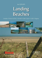
£19.95
One of the titles in the 1:50, 000 topographic survey of Icel&. The series is not complete. So far 102 maps have been published, out of the total of 199, with the north-west & the east of the country not yet covered. The series has been compiled from aerial photography & has contours at 20m intervals. The maps do not give as much information on the type of the terrain & land use as the 1:100, 000 series, but the cartography

Includes::
many other

Features:
hot & cold springs & wells, streams graded by width, etc. Each map covers an area of Approx. 23 x 28 km / 14 x 17 miles. The maps have a UTM grid, with margin ticks showing latitude & longitude in steps of 5'. Map legend

Includes::
English.


...
Archived Product
£8.99
An epic voyage, undertaken with the grandest of ambitions. Laperouse leaves France in the Spring of 1785 with two ships under his comm&, knowing that he sails with the full backing of the French government. This is to be a voyage of scientific & geographical discovery
- but every person on board has their own hopes, ambitions & dreams. As the ships move across vast distances in their journey of nearly four years, the different characters step forward & invite us into their world. From the remote Alaskan bay where a dreadful tragedy unfolds, to the wild journey Barthelemy de Lessups undertakes from the far east of Russia to St Petersburg, the reader is irresistibly drawn into a extraordinarily vivid world. Landfalls is a profoundly moving & intensely evocative novel about scientific exploration, human endeavour & individual tragedy,
...
Archived Product
£14.99
An epic voyage, undertaken with the grandest of ambitions. When Laperouse leaves France in the Spring of 1785 with two ships under his comm&, he knows that he sails with the full backing of the French government. This is to be a voyage of scientific & geographical discovery
- but every person on board has their own hopes, ambitions & dreams. As the ships move across vast distances in their journey of nearly four years, the different characters step forward & invite us into their world. From the remote Alaskan bay where a dreadful tragedy unfolds, to the wild journey Barthelemy de Lessups undertakes from the far east of Russia to St Petersburg, the reader sees the emotional, physical & mental toll exacted by such an endeavour. Landfalls marks the launch of a brilliant new writer, who creates an unforgettable world through a web of voices & narratives.
...
Archived Product
£9.99
For Ibn Batuttah of Tangier, being medieval didn`t mean sitting at home waiting for renaissances, enlightenments & easy Jet. It meant travelling the known world to its limits. Seven centuries on, Tim Mackintosh-Smith`s passionate pursuit of the fourteenth-century traveller takes him to landfalls in remote tropical islands, torrid Indian Ocean ports & dusty towns on the shores of the Saharan s&-sea. His zigzag itinerary across time & space leads from Zanzibar to the Alhambra (via the Maldives, Sri Lanka, China, Mauritania & Guinea) & to a climactic conclusion to his quest for the man he calls `IB`
- a man who out-travelled Marco Polo by a factor of three, who spent his days with saints & sultans & his nights with an intercontinental string of slave-concubines. Tim`s journey is a search for survivals from IB`s world
- material, human, spiritual, edible
- however, when your fellow traveller has a 700-year head start, familiar notions don`t always work.


...
Archived Product
£16.00
A groundbreaking new book from the author of The Running Sky & Four Fields, Landfill confronts our waste-making species through the extraordinary & fascinating life of gulls, and the people who watch them. Original, compelling & unflinching, it is the nature book for our times. ...
Archived Product
£12.99
Topographic survey of France at 1:25, 000 in IGN`s excellent TOP25 / Série Bleue series. All the maps are GPS compatible, with a 1km UTM grid plus latitude & longitude lines at 5’ intervals. Contours are at 5m intervals except for mountainous areas where the maps have contours at 10m intervals, vividly enhanced by hill shading & graphics for rocky terrain. Colouring with graphics indicates different types of vegetation or land use (deciduous or coniferous forests, moors, orchards, vineyards, etc). PLEASE NOTE: coverage of France at this scale is currently being revised – the format & the presentation of each title are indicated by the letters at the end of its Sheet Reference number (e.g. 0416ET, 3531ETR, 1923SB, etc.)MAPS WITH FULL TOURIST OVERPRINT & AN ENGLISH MAP LEGEND: all TOP25 maps & the SB editions of Série Bleue have an overprint highlighting waymarked walking trails including long-distance GR routes &, where appropriate, ski routes. Symbols indicate campsites, gîtes d’etape, refuges, equestrian centres & other recreational facilities or sites, tourist information centres, cultural heritage, etc. Towns & locations of particular interest are highlighted.- ET or OT = single-sided TOP25 map covering approx. 29x 21 km / 18x 13 miles.- ETR or OTR = waterproof & tear resistant TOP25 map covering the same area as the corresponding ET or OT number, but double-sided, printed on a smaller size sheet with a good overlap between the sides.- SB = Série Bleue map with full tourist overprint; these maps, first introduced in summer 2014, each cover approx. 29x 24km / 18x 15 miles.SÉRIE BLEUE maps with numbers ending in E (Est) or O (Ouest): most editions now indicate the GR routes, but do not show any other tourist information. Map legend is in French only. Each map covers approx. 14x 20km / 9x 12 miles. ...
Archived Product
£11.50
Topographic survey of France at 1:25, 000 in IGN`s excellent TOP25 / Série Bleue series. All the maps are GPS compatible, with a 1km UTM grid plus latitude & longitude lines at 5’ intervals. Contours are at 5m intervals except for mountainous areas where the maps have contours at 10m intervals, vividly enhanced by hill shading & graphics for rocky terrain. Colouring with graphics indicates different types of vegetation or land use (deciduous or coniferous forests, moors, orchards, vineyards, etc). PLEASE NOTE: coverage of France at this scale is currently being revised – the format & the presentation of each title are indicated by the letters at the end of its Sheet Reference number (e.g. 0416ET, 3531ETR, 1923SB, etc.)MAPS WITH FULL TOURIST OVERPRINT & AN ENGLISH MAP LEGEND: all TOP25 maps & the SB editions of Série Bleue have an overprint highlighting waymarked walking trails including long-distance GR routes &, where appropriate, ski routes. Symbols indicate campsites, gîtes d’etape, refuges, equestrian centres & other recreational facilities or sites, tourist information centres, cultural heritage, etc. Towns & locations of particular interest are highlighted.- ET or OT = single-sided TOP25 map covering approx. 29x 21 km / 18x 13 miles.- ETR or OTR = waterproof & tear resistant TOP25 map covering the same area as the corresponding ET or OT number, but double-sided, printed on a smaller size sheet with a good overlap between the sides.- SB = Série Bleue map with full tourist overprint; these maps, first introduced in summer 2014, each cover approx. 29x 24km / 18x 15 miles.SÉRIE BLEUE maps with numbers ending in E (Est) or O (Ouest): most editions now indicate the GR routes, but do not show any other tourist information. Map legend is in French only. Each map covers approx. 14x 20km / 9x 12 miles. ...
Archived Product
£15.99
Landmannlaugar
- Þórsmörk
- Fjallabak area of Iceland at 1:100, 000 in a series of detailed hiking & recreational topographic

...
Archived Product
£8.99
Landscapes of beauty...in a world that time seems to have passed by. Step away from the city's hustle & bustle & into the country, where old castles & abbeys st&, where small villages maintain their charm, where the spirit of long ago still burns bright, unextinguished by the modern age. Striking photographs bring forth all the magic & romance of rural areas throughout Britain & France -- the highlands & islands; the gardens with fountains, topiary, cottage flowers, & fragrant herbs; the canals & country railways; the small pubs where one can still quaff a pint among friends. What wonderful places to be. ...
Archived Product
£25.00
This illustrated book celebrates the Landmark Trust`s achievement in the protection of British heritage since the Trust was established 50 years ago. From a medieval hall house to the winner of the 2013 Stirling Prize for Architecture, 50 buildings rescued by Landmark from threatened oblivion are presented here that vividly illustrate the history of Britain from 1250 to the present day. Presented in the order in which they were built, the selected buildings include the unusual, the fantastic, the spectacular, the utilitarian & the enchanting, each one offering a fascinating glimpse into the past of the British people. In telling the stories of how the buildings came to be, how they were used & how they were adapted by subsequent generations, this book brings history to life through the evidence in the buildings our ancestors have left behind. Examples include a 15th-century inn in Suffolk, an Elizabethan hospital in Yorkshire, a lighthouse on Lundy & an Italianate railway station. The Landmark Trust`s often heroic rescue of each of these buildings is also placed in the context of the Trust`s own evolution to date & the history of British conservation practice. For everyone interested in British history or architecture, this enthralling book will bring fresh insights into both; for everyone interested in buildings conservation, the book will provide an insight into the unique national treasure that is the Landmark Trust. ...
Archived Product

Landing Beaches

Sainte-Me`re-E`glise, Pointe du Hoc, Ouistreham, Omaha Beach, Pegasus Bridge, Arromanches... so many names entered into history on the morning of the 6th of June 1944, to remain forever engraved in our memories. This fully illustrated guide, including period documents and color photographs, offers an insight, sector by sector, place by place, not only of the legendary D-day landing sites, but also of less familiar places.Enhanced by original maps, a series of ”close-up views” offering detailed explanations, ”at a glance” pages devoted to specific towns or sites and an introduction to the many museums open to curious visitors.
RIP - This product is no longer available on our network. It was last seen on 25.09.2019

This page now acts as a permanent archive for this product. Add more information using the comments box below to ensure it can still be found by future generations.

Use our search facility to see if it is available from an alternative contributor.
  • External links may include paid for promotion
  • Availability: Out Of Stock
  • Supplier: Stanfords
  • SKU: 9782915762709
Availability: In Stock
£16.99

Product Description

Sainte-Me`re-E`glise, Pointe du Hoc, Ouistreham, Omaha Beach, Pegasus Bridge, Arromanches... so many names entered into history on the morning of the 6th of June 1944, to remain forever engraved in our memories. This fully illustrated guide, including period documents & color photographs, offers an insight, sector by sector, place by place, not only of the legendary D-day landing sites, but also of less familiar places. Enhanced by original maps, a series of ”close-up views” offering detailed explanations, ”at a glance” pages devoted to specific towns or sites & an introduction to the many museums open to curious visitors.

Reviews/Comments

Add New

Intelligent Comparison

Oooops!
We couldn't find anything!
Perhaps this product's unique.... Or perhaps we are still looking for comparisons!
Click to bump this page and we'll hurry up.

Price History

Vouchers

No voucher codes found.
Do you know a voucher code for this product or supplier? Add it to Insights for others to use.

Facebook

Jargon Buster

Beach - An area on the coast consisting of a sandy or pebbled area
History - Anything that happens in the past. An acedemic subject.
Day - The time it takes a planet or other space objects to complete one rotation.

Supplier Information

Stanfords
Stanfords was established in 1853 and opened their iconic Covent Garden flagship store in 1901. They have become the top retailer of maps, travel books and accessories in the UK and arguably offer the largest selection of maps and travel books worldwide. Famous names such as Captain Robert Falcon Scott, Ranulph Fiennes and Michael Palin have purchased from Stanfords. They now have a shop in Bristol and both stores together with other venues operate a calendar of events including talks, book signings and exhibitions. As a specialist map retailer, the map selection is comprehensive and includes road maps, street maps and walking maps from worldwide destinations, as well as a selection of world atlases and wall maps. Books include travel guides and travel literature. Stanfords also stock globes, from miniatures made of blue marble to magnificent floor-standing globes. The website features a selection of interesting articles on travel topics.
Page Updated: 2023-11-12 20:15:36

Community Generated Product Tags

Oh No! The productWIKI community hasn't generated any tags for this product yet!
Menu