
 United Kingdom
 France
 Germany
 Netherlands
 Sweden
 USA
USA
 Italy
Italy
 Spain
Spain
More From Contributor
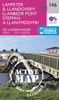

Lampeter And Llandovery / Llanbedr Pont Steffan A Llanymddyfri
Map No. 146, Lampeter and Llandovery / Llanbedr Pont Steffan a Llanymddyfri, in the Ordnance Survey Landranger series at 1:50, 000, including Aberaeron, Aberath, Bethania, Llangeitho, Blaenpennal, Tregaron, Llwyn-y-groes, Llanddewi-Brefi, Llundain-fach, Gilfachreda, Ciliau Aeron, Llanarth, Mydroilyn, Talgarreg, Temple Bar, Cwrtnewydd, Rhydowen, Dre-fach, Cwmann, Ffarmers, Rhandirmwyn, Cilycwm, Pumsaint, Rhydcymerau, Llanbydder, Llanysul, Pencader, Llanllwni, Gwernogle, Alltwalis, Llanpumsaint, Llansawl, Abergorlech, Talley, Brechfa, Horeb, Llanfynydd, Salem, Cwmifor, Llangadog, Muddfai and Talsarb, with part of the Llyn Brianne Reservoir, Brechfa Forest, the peaks od Bryn Mawr, Esgair Llethr and Craig Siarls, plus a small part of the Brecon
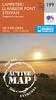
Beacons National Park/Parc Cenedlaethol Bannau Brycheiniog. Edition B2; Publication Date March 2011 This title is also available on our website in a waterproof and tear-resistant version.Maps in this series are only published folded. Stanfords can also print flat versions of Ordnance Survey maps through the OS Select system, centring the map on a location of your choice and with a picture provided by you on the cover. For more information please click on the link at the bottom of this description.About Ordnance Survey
Beacons National Park/Parc Cenedlaethol Bannau Brycheiniog. Edition B2; Publication Date March 2011 This title is also available on our website in a waterproof and tear-resistant version.Maps in this series are only published folded. Stanfords can also print flat versions of Ordnance Survey maps through the OS Select system, centring the map on a location of your choice and with a picture provided by you on the cover. For more information please click on the link at the bottom of this description.About Ordnance Survey
Product Description
Reviews/Comments
Add New
Intelligent Comparison
Archived Product
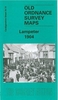
Lampeter And Llandovery / Llanbedr Pont Steffan A Llanymddyfri 1923 Stanfords
£9.99
Archived Product
Lampeter And Llandovery / Llanbedr Pont Steffan A Llanymddyfri 1831-1834 Stanfords
£9.99
Archived Product

Lampeter And Llandovery / Llanbedr Pont Steffan A Llanymddyfri 1901-1902 Stanfords
£9.99
Archived Product
Lampeter And Llandovery / Llanbedr Pont Steffan A Llanymddyfri WATERPROOF Stanfords
£10.39
Archived Product
Lampeter And Llandovery / Llanbedr Pont Steffan A Llanymddyfri 1831-1923 (3-map Set) Stanfords
£14.99
Vouchers
No voucher codes found.
Do you know a voucher code for this product or supplier? Add it to Insights for others to use.
Do you know a voucher code for this product or supplier? Add it to Insights for others to use.
 Denmark