More From Contributor
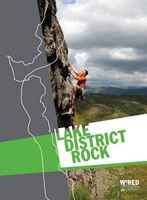
£6.99
Selected areas of the Lake District on a laminated & waterproof map from Goldeneye presenting 10 specially chosen off-road circular routes highlighted on contoured map extracts at scales around 1:25, 000 / 1:50, 000, annotated with directions & accompanied by brief descriptions. Map extracts cover circuits from/around: Skiddow – Keswick, Blencathra, Keswick Railway Path & Castlerigg Stone Circle, Threlkeld – Troutbeck & the Old Coach Road, Loweswater – Buttermere, Watendlath – Honister, Pooley Bridge – Askham Fell, Eskdale, Coniston – Banishead Quarries – Torver, & Windermere – Kentmere – Garburn Pass, Each map panel shows the topography by contour lines, in most titles at 50 foot intervals, with additional altitude colouring & spot heights. The route is prominently highlighted including, where appropriate, sections on the road network & is annotated at various points with instructions. Symbols indicate various landmarks & places of interest. The maps have no coordinates for GPS navigation. Each map extract is accompanied by details of the overall route distance, timing, grade & refreshment points, plus a brief description. ...
Archived Product
£8.99
Lake District National Park on an unusual & interesting wall map from The Outstanding Map Company, size 60 x 85cm / 24’ x 34’ approx., with excellent presentation of the topography & a list of the summits with altitude, printed on high quality paper. The map uses satellite imagery enhanced by bold relief shading to provide an excellent presentation of the fells. The network of rivers, streams & canals is clearly visible & waterfalls are marked. Additional colouring shows towns or villages, enclosed farmland & woodl&. The map also shows local road network, railway lines with stations (including preserved or narrow gauge lines), & ferry routes on the lakes. Numerous place names show not only geographical

Features:
fells, pikes & other peaks, dales, etc, but also towns, villages, & selected tourist sites such as museums, etc. An index lists all the summits named on the map in descending order of height. A decorative frame gives the National Grid values in steps of one kilometre.

...
Archived Product
£12.95
The northern part of the Lake District at 1:25, 000 on a light, waterproof & tear-resistant map from Harvey Map Services in their Superwalker series. Coverage

Includes::
Cockermouth, Keswick, Buttermere, Bassenthwaite Lake, Derwentwater, Thirlmere, Ennerdale Water, Crummock Water, the peak of Skiddaw, etc, & extends south just beyond Ennerdale Bridge, Rosthwaite & Patterdale.PLEASE NOTE: this title is also available as a pocket-size Ultramap with its scale reduced to 1:40, 000
- to see the list of titles available in this series please click on the series link. Maps in Harvey’s Superwalker series have contours at 15m intervals, with additional graphics for various types of terrain (crags, large boulders, scattered rocks) & colouring for different kinds of land use or vegetation (pastures, bogs, forests or woodl&, etc). The maps show local hiking paths, indicating where appropriate long-distance routes, & boundaries of national parks or other protected areas. Scottish titles also indicate Munro, Corbett & Graham hills. Some maps in addition highlight local cycle routes. A range of symbols mark various facilities for walkers including youth or independent hostels, campsites & caravan sites, information points, etc. Each map has a 1-km British or Irish national grid.


...
Archived Product
£9.95
The northern part of the Lake District at 1:40, 000 on a waterproof & tear-resistant, pocket-size Ultramap from Harvey Map Services with the same cartography as their Superwalker map of this area. Coverage

Includes::
Cockermouth, Keswick, Buttermere, Bassenthwaite Lake, Derwentwater, Thirlmere, Ennerdale Water, Crummock Water, the peak of Skiddaw, etc, & extends south just beyond Ennerdale Bridge, Rosthwaite & Patterdale.PLEASE NOTE: this title is also available as a Superwalker map at 1:25, 000
- to see the list of titles available in this series please click on the series link. Maps in Harvey’s Superwalker series have contours at 15m intervals, with additional graphics for various types of terrain (crags, large boulders, scattered rocks) & colouring for different kinds of land use or vegetation (pastures, bogs, forests or woodl&, etc). The maps show local hiking paths, indicating where appropriate long-distance routes, & boundaries of national parks or other protected areas. Scottish titles also indicate Munro, Corbett & Graham hills. Some maps in addition highlight local cycle routes. A range of symbols mark various facilities for walkers including youth or independent hostels, campsites & caravan sites, information points, etc. Each map has a 1-km British or Irish national grid.


...
Archived Product
£9.95
Detailed topographical map of the Lake District’s famous mountains & fells, at a scale of 1:40, 000; this spiral-bound volume is waterproof & ideal for carrying in a map case of map pocket. The cartography has colour shading for easy identification of hills & valleys, with detailed crag information for climbers. All roads, footpaths & rights of way or shown, as are car parks, caravan sites, youth hostels & mountain rescue posts & areas of local interest. Contour lines are at 15m intervals, with index contours at 75m intervals. Spot heights are also shown, as are major crags & even large boulders. The introduction contains information on how to use the atlas effectively, as well as safety advice on walking & cycling in the lake district; the countryside code; access information; accommodation & useful local phone numbers. ...
Archived Product
£8.95
Map of the Lake District on playing cards. Map area shown covers Scafell & Scafell Pike in the West, to Ambleside & Windermere in the East. Shows original HARVEY mapping. Central Lake District, Scafell to Windermere, shown across 52 cards. Each card shows a unique piece of map. Standard pack contains 52 playing cards & 3 jokers. ...
Archived Product
£5.99
Short Walks in The Lake District is a slim, pocket sized volume produced in conjunction with the Ramblers & Ordnance Survey, which details 20 easy walks of 3 hours or less. All walks are less than 5 miles in length & suitable for beginners & family groups. Routes are vividly marked on OS map pages produced at a scale of 1:25, 000 (unless otherwise stated), with corresponding route instructions denoted by a capital letter & points of interest denoted by numbers in the text. Walk symbols indicate whether each walk can be noted for reasons of birdlife, other wildlife, wild flowers, woodl&, historical interest, geology, literature or good views. Parking facilities are also indicated. Route fact files contain at-a-glance information including distance, time, start/end points, terrain & the relevant OS maps to use. ...
Archived Product
£9.95
A celebration of one of England's most alluring & picturesque regions, the Lake District Sketchbook is packed with over 200 beautiful line & watercolour illustrations of some of the author's favourite places in the magnificent English lakel&. The illustrations are accompanied by historical footnotes, quirky facts, some easy walks, identification of mountain scenes, a gazetteer &, most importantly, where to park & get a cup of tea! The Lake District is Britain's premier tourist region, attracting visitors from throughout the world, which ensures a huge market for the Lake District Sketchbook, which is both a useful guidebook & ideal souvenir. Jim Watson is an experienced illustrator & writer with three best-selling, award-winning books on the English Lake District to his credit: Lakeland Villages, Lakeland Towns & Lakeland Panoramas. He has also written & illustrated the definitive guide to two long-distance walks across Lakeland: The Cumbria Way & The Allerdale Ramble.A unique book, in handy A5 format, beautifully bound & printed in colour throughout, the Lake District Sketchbook, along with the Cotswolds Sketchbook, are the first titles in a new series celebrating the most beautiful regions of Britain. Casebound & printed in colour. ...
Archived Product
£12.95
The south-eastern part of the Lake District at 1:25, 000 on a light, waterproof & tear-resistant map from Harvey Map Services in their Superwalker series. Coverage

Includes::
Kendal, Windermere, Bowness-on-Windermere, Coniston, Newby Bridge, Coniston Water, Lake Windermere, etc, & extends from Ambleside in the north to Newby Bridge in the south.PLEASE NOTE: this title is also available as a pocket-size Ultramap with its scale reduced to 1:40, 000
- to see the list of titles available in this series please click on the series link. Maps in Harvey’s Superwalker series have contours at 15m intervals, with additional graphics for various types of terrain (crags, large boulders, scattered rocks) & colouring for different kinds of land use or vegetation (pastures, bogs, forests or woodl&, etc). The maps show local hiking paths, indicating where appropriate long-distance routes, & boundaries of national parks or other protected areas. Scottish titles also indicate Munro, Corbett & Graham hills. Some maps in addition highlight local cycle routes. A range of symbols mark various facilities for walkers including youth or independent hostels, campsites & caravan sites, information points, etc. Each map has a 1-km British or Irish national grid.


...
Archived Product
£9.95
The south-eastern part of the Lake District at 1:40, 000 on a waterproof & tear-resistant, pocket-size Ultramap from Harvey Map Services with the same cartography as their Superwalker map of this area. Coverage

Includes::
Kendal, Windermere, Bowness-on-Windermere, Coniston, Newby Bridge, Coniston Water, Lake Windermere, etc, & extends from Ambleside in the north to Newby Bridge in the south.PLEASE NOTE: this title is also available as a Superwalker map at 1:25, 000
- to see the list of titles available in this series please click on the series link. Maps in Harvey’s Superwalker series have contours at 15m intervals, with additional graphics for various types of terrain (crags, large boulders, scattered rocks) & colouring for different kinds of land use or vegetation (pastures, bogs, forests or woodl&, etc). The maps show local hiking paths, indicating where appropriate long-distance routes, & boundaries of national parks or other protected areas. Scottish titles also indicate Munro, Corbett & Graham hills. Some maps in addition highlight local cycle routes. A range of symbols mark various facilities for walkers including youth or independent hostels, campsites & caravan sites, information points, etc. Each map has a 1-km British or Irish national grid.


...
Archived Product

Lake District Rock

Lake District Rock contains over 1, 500 climbs on 85 crags and features clear maps, crisp photodiagram coverage for every crag and sensational images. The banners and sidebar reflect the familiar FRCC colours making it easy to find each section. Dow, Coppermines & Slate, Duddon & Eskdale and Borrowdale - receive the `modern` treatment and Bramcrag Quarry has a complete makeover with all of the recent developments featured. This is an inspirational selected guidebook, from the authority on Lakeland rock climbing.The Fell & Rock Climbing Club is the premier rock climbing and mountaineering club in the English Lake District. The Club was founded in 1906-07 and has been publishing a definitive series of climbing guidebooks to the Lakes since 1922.
RIP - This product is no longer available on our network. It was last seen on 25.09.2019

This page now acts as a permanent archive for this product. Add more information using the comments box below to ensure it can still be found by future generations.

Use our search facility to see if it is available from an alternative contributor.
  • External links may include paid for promotion
  • Availability: Out Of Stock
  • Supplier: Stanfords
  • SKU: 9780850280579
Availability: In Stock
£29.95

Product Description

Lake District Rock contains over 1, 500 climbs on 85 crags & features clear maps, crisp photodiagram coverage for every crag & sensational images. The banners & sidebar reflect the familiar FRCC colours making it easy to find each section. Dow, Coppermines & Slate, Duddon & Eskdale & Borrowdale
- receive the `modern` treatment & Bramcrag Quarry has a complete makeover with all of the recent developments featured. This is an inspirational selected guidebook, from the authority on Lakeland rock climbing. The Fell & Rock Climbing Club is the premier rock climbing & mountaineering club in the English Lake District. The Club was founded in 1906-07 & has been publishing a definitive series of climbing guidebooks to the Lakes since 1922.

Reviews/Comments

Add New

Intelligent Comparison

Oooops!
We couldn't find anything!
Perhaps this product's unique.... Or perhaps we are still looking for comparisons!
Click to bump this page and we'll hurry up.

Price History

Vouchers

No voucher codes found.
Do you know a voucher code for this product or supplier? Add it to Insights for others to use.

Facebook

Jargon Buster

Makeover - To be pampered and made to look good.
Treatment - A way in which medics care for patients illnesses. A manner which someone behaves to someone else.
Sensational - Something that is outstanding, usually causing public interest.

Supplier Information

Stanfords
Stanfords was established in 1853 and opened their iconic Covent Garden flagship store in 1901. They have become the top retailer of maps, travel books and accessories in the UK and arguably offer the largest selection of maps and travel books worldwide. Famous names such as Captain Robert Falcon Scott, Ranulph Fiennes and Michael Palin have purchased from Stanfords. They now have a shop in Bristol and both stores together with other venues operate a calendar of events including talks, book signings and exhibitions. As a specialist map retailer, the map selection is comprehensive and includes road maps, street maps and walking maps from worldwide destinations, as well as a selection of world atlases and wall maps. Books include travel guides and travel literature. Stanfords also stock globes, from miniatures made of blue marble to magnificent floor-standing globes. The website features a selection of interesting articles on travel topics.
Page Updated: 2023-11-12 20:15:36

Community Generated Product Tags

Oh No! The productWIKI community hasn't generated any tags for this product yet!
Menu