More From Contributor

£32.99
The 900km-long pilgrimage trail of the Via Francigena across Italy from Montgenèvre in the Alps to Rome on a set of maps at 1:30, 000 from Terre di Mezzo, presenting each of the 39 stages & their variants on panels with contoured mapping (interval 100m) accompanied by a route profile, a set of GPS coordinates for several points along the stage, length & ascent/descent, road surface/country path, etc. The route & its variants are clearly highlighted on each panel, & symbols indicate accommodation facilities, various landmarks or places of interest (churches, etc), & the points for which the GPS coordinates have been supplied. Map legend is in a separate bilingual English/ Italian booklet which

Includes::
notes on how this set was prepared, etc.VERY IMPORTANT – PLEASE DO READ BEFORE ORDERING: 1) Each of the three maps in this set is perforated along its vertical folds & the perforations start splitting as soon as the map is opened. This does not damage the maps or their supporting information panels. Orders for this title might be supplied with some perforations already partly split.2) We are doing our best to ensure that this title is in stock but deliveries are irregular & we cannot indicate any delivery time when this title is not in stock.

...
Archived Product
£20.50
La Vienne à pied, FFRP topo-guide Ref. No. D086, with 36 day walks of varying length & difficulty in the department of Vienne around Poitiers. Current edition of this title was published in August 2008. To see the list of other FFRP guides with day walks please click on the series link.ABOUT THE FFRP (Fédération française de la randonnée pédestre) TOPOGUIDES: published in a handy A5 paperback format, the guides are the best companions for hiking in France. In addition to their topo-guides to the long-distance GR routes FFRP also publish an extensive range of guides with local day walks. Each walk in presented on a colour extract from IGN`s 1:50, 000 or 1:25, 000 topographic survey mapping overprinted with the route, with important points cross-referenced to the accompanying text, in French only, placed on the adjoining page. For each walk the guides also indicate the degree of difficulty & provide information on length, time & change in altitude, waymarking signs, access by road & parking facilities. An “info practiques” section of the guide indicates where shops, restaurants & accommodation can be found. The guides are published on high quality paper & include descriptions of the most interesting aspects of the surrounding region: historical & cultural sites, local specialties, fauna & flora, etc, all illustrated with colour photos. ...
Archived Product
£8.99
Lab Girl is a book about work & about love, & the mountains that can be moved when those two things come together. It is told through Jahren`s remarkable stories: about the discoveries she has made in her lab, as well as her struggle to get there; about her childhood playing in her father`s laboratory; about how lab work became a sanctuary for both her heart & her hands; about Bill, the brilliant, wounded man who became her loyal colleague & best friend; about their field trips
- sometimes authorised, sometimes very much not
- that took them from the Midwest across the USA, to Norway & to Irel&, from the pale skies of North Pole to tropical Hawaii; & about her constant striving to do & be her best, & her unswerving dedication to her life`s work. Visceral, intimate, gloriously candid & sometimes extremely funny, Jahren`s descriptions of her work, her intense relationship with the plants, seeds & soil she studies, & her insights on nature enliven every page of this thrilling book. In Lab Girl, we see anew the complicated power of the natural world, & the power that can come from facing with bravery & conviction the challenge of discovering who you are.

...
Archived Product
£11.50
Topographic survey of France at 1:25, 000 in IGN`s excellent TOP25 / Série Bleue series. All the maps are GPS compatible, with a 1km UTM grid plus latitude & longitude lines at 5’ intervals. Contours are at 5m intervals except for mountainous areas where the maps have contours at 10m intervals, vividly enhanced by hill shading & graphics for rocky terrain. Colouring with graphics indicates different types of vegetation or land use (deciduous or coniferous forests, moors, orchards, vineyards, etc). PLEASE NOTE: coverage of France at this scale is currently being revised – the format & the presentation of each title are indicated by the letters at the end of its Sheet Reference number (e.g. 0416ET, 3531ETR, 1923SB, etc.)MAPS WITH FULL TOURIST OVERPRINT & AN ENGLISH MAP LEGEND: all TOP25 maps & the SB editions of Série Bleue have an overprint highlighting waymarked walking trails including long-distance GR routes &, where appropriate, ski routes. Symbols indicate campsites, gîtes d’etape, refuges, equestrian centres & other recreational facilities or sites, tourist information centres, cultural heritage, etc. Towns & locations of particular interest are highlighted.- ET or OT = single-sided TOP25 map covering approx. 29x 21 km / 18x 13 miles.- ETR or OTR = waterproof & tear resistant TOP25 map covering the same area as the corresponding ET or OT number, but double-sided, printed on a smaller size sheet with a good overlap between the sides.- SB = Série Bleue map with full tourist overprint; these maps, first introduced in summer 2014, each cover approx. 29x 24km / 18x 15 miles.SÉRIE BLEUE maps with numbers ending in E (Est) or O (Ouest): most editions now indicate the GR routes, but do not show any other tourist information. Map legend is in French only. Each map covers approx. 14x 20km / 9x 12 miles. ...
Archived Product
£15.99
Cycling route along the Elbe/ Labe in the Czech Republic from its source in the Krkonoše Mountains to the German border, including a variant to Prague, presented by the Verlag Esterbauer in guide with maps at 1:75, 000 showing the route & its variants. Extensive information is conveyed by symbols, indicating road surface, campsites & other accommodation, repair workshops, recreational facilities, places of interest, etc. A list of various types of accommodation facilities is included.IMPORTANT
- PLEASE NOTE BEFORE ORDERING
- ALL THE TEXT IN THIS TITLE IS GERMAN ONLY. MAP LEGEND

Includes::
ENGLISH (please see our sample image) & the information provided on the maps is sufficient to use this title without any knowledge of German.ABOUT THE BIKELINE SERIES: all the titles have been meticulously researched & are highly regarded in their native Germany. Most titles, as indicated in their individual descriptions, also include a separate section listing selected accommodation, from hotels to campsites, youth hostels & rooms in private houses, all with addresses, telephone numbers & price range. Information on towns along each route

Includes::
a list of places of interest, with opening hours, etc. Several of the guides also have street plans. To see the list of other titles in the Bikeline series please click on the series link.


...
Archived Product
£7.99
As the end of summer approaches & a long, hot Labor Day weekend looms, the life of lonely thirteen-year-old Henry Wheeler is irrevocably changed when he & his emotionally fragile mother show kindness to a stranger with a terrible secret. Now a major motion picture starring Kate Winslet & Josh Brolin, Labor Day is a poignant story of love, sex, adolescence, & devastating treachery. ...
Archived Product
£20.00
A social history of Labradors, & how they have become the world`s most beloved dogs, by writer, presenter & long-time dog lover Ben Fogle, whose beloved black Labrador, Inca, famously accompanied him on numerous journeys & adventures. Labradors are the most popular breed of dog in the world. Not only a great family companion, they also excel at hunting, tracking, retrieving, guiding & rescuing. But where did the breed originally come from? How did it develop? When did black, yellow & chocolate Labradors first appear? Did they really all come from Labrador in Canada & are they really all related to just one dog? In this first history of the Labrador, Ben Fogle goes in search of what makes Labradors so special. Their extraordinary companionship, intelligence, work ethic & loyalty is captured by Ben as he weaves the story of the breed into his own story of his beloved Inca. Ben visits Canada, discovers hair-raising stories of early Labrador exploits & uncovers stories of RNIB Labradors & Labradors at war, Labradors as working dogs & every other manifestation of the Labrador`s character. Exploring their origin, early characteristics, their use as gun dogs, as therapy dogs, as police dogs, as search & rescue dogs & last
- & absolutely not least
- as family pets, Ben tells the story of a dog breed which has captured our imagination & love for hundreds of years.

...
Archived Product
£8.99
A social history of Labradors, & how they have become the world`s most beloved dogs, by writer, presenter & long-time dog lover Ben Fogle, whose beloved black Labrador, Inca, famously accompanied him on numerous journeys & adventures. Labradors are the most popular breed of dog in the world. Not only a great family companion, they also excel at hunting, tracking, retrieving, guiding & rescuing. But where did the breed originally come from? How did it develop? When did black, yellow & chocolate Labradors first appear? Did they really all come from Labrador in Canada & are they really all related to just one dog? In this first history of the Labrador, Ben Fogle goes in search of what makes Labradors so special. Their extraordinary companionship, intelligence, work ethic & loyalty is captured by Ben as he weaves the story of the breed into his own story of his beloved Inca. Ben visits Canada, discovers hair-raising stories of early Labrador exploits & uncovers stories of RNIB Labradors & Labradors at war, Labradors as working dogs & every other manifestation of the Labrador`s character. Exploring their origin, early characteristics, their use as gun dogs, as therapy dogs, as police dogs, as search & rescue dogs & last
- & absolutely not least
- as family pets, Ben tells the story of a dog breed which has captured our imagination & love for hundreds of years.

...
Archived Product
£12.99
Topographic survey of France at 1:25, 000 in IGN`s excellent TOP25 / Série Bleue series. All the maps are GPS compatible, with a 1km UTM grid plus latitude & longitude lines at 5’ intervals. Contours are at 5m intervals except for mountainous areas where the maps have contours at 10m intervals, vividly enhanced by hill shading & graphics for rocky terrain. Colouring with graphics indicates different types of vegetation or land use (deciduous or coniferous forests, moors, orchards, vineyards, etc). PLEASE NOTE: coverage of France at this scale is currently being revised – the format & the presentation of each title are indicated by the letters at the end of its Sheet Reference number (e.g. 0416ET, 3531ETR, 1923SB, etc.)MAPS WITH FULL TOURIST OVERPRINT & AN ENGLISH MAP LEGEND: all TOP25 maps & the SB editions of Série Bleue have an overprint highlighting waymarked walking trails including long-distance GR routes &, where appropriate, ski routes. Symbols indicate campsites, gîtes d’etape, refuges, equestrian centres & other recreational facilities or sites, tourist information centres, cultural heritage, etc. Towns & locations of particular interest are highlighted.- ET or OT = single-sided TOP25 map covering approx. 29x 21 km / 18x 13 miles.- ETR or OTR = waterproof & tear resistant TOP25 map covering the same area as the corresponding ET or OT number, but double-sided, printed on a smaller size sheet with a good overlap between the sides.- SB = Série Bleue map with full tourist overprint; these maps, first introduced in summer 2014, each cover approx. 29x 24km / 18x 15 miles.SÉRIE BLEUE maps with numbers ending in E (Est) or O (Ouest): most editions now indicate the GR routes, but do not show any other tourist information. Map legend is in French only. Each map covers approx. 14x 20km / 9x 12 miles. ...
Archived Product

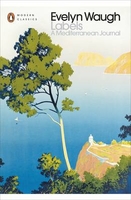
Labels: A Mediterranean Journal

Evelyn Waugh chose the name ”Labels” for his first travel book because, he said, the places he visited were already ”fully labelled” in people`s minds. Yet even the most seasoned traveller could not fail to be inspired by his quintessentially English attitude and by his eloquent and frequently outrageous wit. From Europe to the Middle East and North Africa, from Egyptian porters and Italian priests to Maltese sailors and Moroccan merchants - as he cruises around the Mediterranean his pen cuts through the local colour to give an entertaining portrait of the Englishman abroad.
RIP - This product is no longer available on our network. It was last seen on 25.09.2019

This page now acts as a permanent archive for this product. Add more information using the comments box below to ensure it can still be found by future generations.

Use our search facility to see if it is available from an alternative contributor.
  • Availability: Out Of Stock
  • Supplier: Stanfords
  • SKU: 9780140188370
Availability: In Stock
£9.99

Product Description

Evelyn Waugh chose the name ” Labels” for his first travel book because, he said, the places he visited were already ”fully labelled” in people`s minds. Yet even the most seasoned traveller could not fail to be inspired by his quintessentially English attitude & by his eloquent & frequently outrageous wit. From Europe to the Middle East & North Africa, from Egyptian porters & Italian priests to Maltese sailors & Moroccan merchants
- as he cruises around the Mediterranean his pen cuts through the local colour to give an entertaining portrait of the Englishman abroad.

Reviews/Comments

Add New

Intelligent Comparison

Oooops!
We couldn't find anything!
Perhaps this product's unique.... Or perhaps we are still looking for comparisons!
Click to bump this page and we'll hurry up.

Price History

Vouchers

No voucher codes found.
Do you know a voucher code for this product or supplier? Add it to Insights for others to use.

Facebook

Jargon Buster

Italian - A word used ot descibe something from Italy
Colour - The categorised spectrum of light visable to humans
Attitude - a humans feelings towards a specific person, animal or object.

Supplier Information

Stanfords
Stanfords was established in 1853 and opened their iconic Covent Garden flagship store in 1901. They have become the top retailer of maps, travel books and accessories in the UK and arguably offer the largest selection of maps and travel books worldwide. Famous names such as Captain Robert Falcon Scott, Ranulph Fiennes and Michael Palin have purchased from Stanfords. They now have a shop in Bristol and both stores together with other venues operate a calendar of events including talks, book signings and exhibitions. As a specialist map retailer, the map selection is comprehensive and includes road maps, street maps and walking maps from worldwide destinations, as well as a selection of world atlases and wall maps. Books include travel guides and travel literature. Stanfords also stock globes, from miniatures made of blue marble to magnificent floor-standing globes. The website features a selection of interesting articles on travel topics.
Page Updated: 2023-11-12 20:15:36

Community Generated Product Tags

Oh No! The productWIKI community hasn't generated any tags for this product yet!
Menu