
 United Kingdom
 France
 Germany
 Netherlands
 Sweden
 USA
USA
 Italy
Italy
 Spain
Spain
More From Contributor


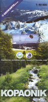
Kopaonik
Kopaonik National Park on a detailed contoured map at 1:40, 000, plus a plan of the resort at Suvo Rudište, a road map of the wider region surrounding the park, panorama map of ski runs, plus notes on fauna and flora, etc. The main map at 1:40, 000 covers the park and the surrounding area with Serbia’s highest mountain Pancic Peak and has contours at 20m intervals, plus graphics and colouring for rocky areas, swamps, deciduous and coniferous forests, etc. Different levels of protection zones are marked and an overprint highlights waymarked hiking trails indicating difficult sections, plus cross-country ski routes. Ski and chair lifts are shown, as well as mountain huts and shelters, hotels, viewpoints, etc. The map has no geographical coordinates. Map legend includes
English.Also provided is a street plan of Suvo Rudište indicating hotels and other accommodation and various services, plus ski and chair lifts. A panorama drawing of the slops shows the lifts and the downhill routes, with a separate table indicating the length and the degree of difficulty. Also provided is a road map of the surrounding region and notes about its fauna and flora, etc.
English.Also provided is a street plan of Suvo Rudište indicating hotels and other accommodation and various services, plus ski and chair lifts. A panorama drawing of the slops shows the lifts and the downhill routes, with a separate table indicating the length and the degree of difficulty. Also provided is a road map of the surrounding region and notes about its fauna and flora, etc.

Product Description
Reviews/Comments
Add New
Vouchers
No voucher codes found.
Do you know a voucher code for this product or supplier? Add it to Insights for others to use.
Do you know a voucher code for this product or supplier? Add it to Insights for others to use.
 Denmark