More From Contributor
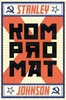
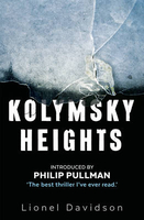
£19.95
Topographic survey of Faroe Islands at 1:20, 000 prepared by the Danish national mapping agency Kort og Matrikelstyrelsen. The islands’ topography is vividly presented by contours at 5 metre intervals, enhanced by relief shading plus colouring and/or graphics for different types of terrain or vegetation (scree, boulders, etc). The maps show all the detail expected of the topographic mapping at this scale & have a 1-km UTM grid, plus margin ticks for latitude & longitude at 1’ & 2` respectively. Map legend is in Danish only. The maps are available either separately or as sets of five of more sheets, each covering the main island group: Vagar, Sandoy, Suduroy, Nordoyar, Streymoy & Eysturoy. To see the list of all the titles in this series please click on the series link. ...
Archived Product
£9.99
Kolonja Prefecture at 1:100, 000 in a series of handy size, waterproof & tear-resistant, contoured & GPS compatible road maps from the Tirana-based publishers Vektor. Landscape is presented by altitude colouring & contours lines at 100m intervals, with spot heights & a few more names of topographic features than found on Vektor’s 200K road maps of the country. National parks & nature reserves are prominently highlighted. The prefecture maps appear to show the same small local dirt roads as in the 200K series, but given the increase in scale do so with greater clarity & also provide more detailed GPS coordinates (latitude & longitude lines are drawn at 5’ intervals), useful when travelling across the more remote parts of the country. Railway lines are included & local airports are marked. Symbols highlight campsites, beaches, archaeological & historical sites, caves, etc. The maps also show subdivisions of prefectures & names of the communes, & indicate administrative status of towns. Map legend

Includes::
English. Please note: border crossings are prominently marked but beyond topographic colouring no road or other information is provided outside the country’s borders.

...
Archived Product
£9.99
Kolti, sheet no. 2981-07 in the topographic survey of Nepal at 1:50, 000 published by the Nepali Government in the late 1990s & early 2000s & produced from remote sensing data by Finnish cartographers as part of that country’s international aid program. The maps cover 15’ x 15’ quadrangles.IMPORTANT – PLEASE NOTE BEFORE ORDERING: AVAILABILITY: although, theoretically at least, still in print, these maps are very difficult to get locally in Nepal and/or from various suppliers elsewhere specializing in obtaining such maps. DELIVERIES MAY TAKE SEVERAL WEEKS OR EVEN MONTHS.PROBLEMS WITH PLACE NAMES: reports from previous users indicate that transliteration of place names differs from that used widely not only on other maps & in guide books but also on the ground itself, in road signs & in the tourist & trekking industry in general. Whilst most names are similar enough to be easily recognizable, e.g. Namche Bajar for Namche Bazar or Lantan for Langtang, we have been told of confusion & difficulties arising from different spellings appearing on these maps.TREKKING ROUTES & TOURIST INFORMATION: whilst the maps show foot trails & mark locations of temples, etc, they carry no specific trekking information. Major trekking routes & places of interest are not highlighted. There is no marking for base camps & other tourist facilities. Map specifications: Contours are at 40m intervals, with graphics and/or coloring to show various features of the terrain (glaciers with moraines & crevasses, quarries, gravel or clay pits, etc.) & vegetation (forests, bush, grass, orchards & plantations, etc). Additional comments such as “open mixed forest mainly bajh & pine” annotate many area. The maps have numerous spot heights, but relatively few peaks are named. Areas outside the country’s borders are left blank. Settlements in remote areas are indicated by markings for individual buildings & the placing of names does not always make it clear which group of buildings they refer to. Road network distinguishes between major & minor foot trails. Symbols mark features such as temples, schools & hospitals, police stations, etc. Also shown are the country’s administrative divisions. The maps have a 1-km UTM grid, plus latitude & longitude lines at intervals of 5’. Map legend & all the text is in English. Coverage: the whole country is now covered, with the north at 1:50, 000, plus central & southern Nepal at 1:25, 000. The two series are complementary, do not overlap & use the same grid & numbering system (apart from the Lumbini Zone, where a different grid & numbering are used). For areas not shown on our grid & titles not listed here, please contact us by e-mail, but please do bear in mind the problems with availability & the likely very long delivery time. ...
Archived Product
£24.99
For a long time Magadan Oblast was closed to tourists. This area with its marvellous nature & unlimited opportunities was associated only with the Kolyma labour camps. Luckily the tragic events of the past became part of the history. Today Magadan Oblast is a dynamically developing region of the Russian Far East, with huge prospects for industrial & tourist development. The untouched beauty of its nature, the gold mines, & the romantic & heroic history of the North will make the tour around Magadan Oblast unforgettable. ...
Archived Product
£16.99
From the author of the award-winning White Fever, Kolyma Diaries is an excursion into one of the world`s last remaining badlands, a place full of Gulag ghosts & living wrecks. All along the 2000 kilometres of the Kolyma highway, Bader is plied with vodka. He hears mesmerizing, sometimes devastating, tales of the journeys that brought his `fellow travellers`, the people who give him lifts, to this benighted l&. This is a book about the descendants of prisoners eking out a living, of conmen & veterans & scrap iron dealers, of corrupt politicians & organised crime. Stories are told of sons given away, husbands who reappear after three decades, scholars who now survive by foraging for mushrooms & berries, sculptors who hoard the heads lopped off statues of Lenin, miners who dig up mass graves while looking for gold, & all the addicts, convicts, fallen heroes & even sportsmen who run away from their troubles & end up in the most remote region in Russia ...
Archived Product
£14.99
Stanley Johnson`s latest political thriller Kompromat claims to recount the story of the most audacious geo-political coup since Genghis Khan & his hordes swept across Asia into Europe. The UK Referendum in June 2016, on Britain`s membership of the EU, was a political showdown a British prime minister thought couldn`t be lost. But the next morning Britain woke up to a shock result. Kompromat explores the skulduggery that might just have gone on behind the scenes. ...
Archived Product
£8.99
2016. The world is on the brink of crisis. In Britain, the British Prime Minister is fighting a referendum he thought couldn`t be lost. In the USA, brash showman, Ronald Craig is fighting a Presidential Election nobody thought he could win. In the USSR, Igor Popov, the Russian President, is using both events as part of his plan to destabilise the West. Three men who could change the course of the world forever. In his brilliant new thriller, Stanley Johnson, former MEP, has written an alternative account of the seismic events that took place on both sides of the Atlantic. ...
Archived Product
£20.00
Konditor & Cook are legends in the baking world. Their contemporary & witty cakes are famous
- Magic Cakes have achieved iconic
...
Archived Product
£17.99
The 1:50 000 topographic map gives a more general picture of the ground features than a basic map. It shows settlements, houses, roads, cultivated areas, waterways, cutting areas, mires, rock exposures, & relief. One map sheet covers an area of 30 x 40 km & one centimetre corresponds to 500 metres on the ground. The 1:50, 000 topographic map is also an ideal complement to nautical charts as it provides useful information about the land areas adjacent to waterways. For example, all Finnish sea areas are covered by 1:50 000 topographic map sheets. ...
Archived Product

Kolymsky Heights

”The best thriller I`ve ever read.” (Philip Pullman). Kolymsky Heights. A Siberian permafrost hell lost in endless nights, the perfect setting for an underground Russian research station. It`s a place so secret it doesn`t officially exist; once there, the scientists are forbidden to leave. But one scientist is desperate to get a message to the outside world. So desperate, he sends a plea across the wildness to the West in order to summon the one man alive capable of achieving the impossible...”Sensationally good. Cleverly conceived and brilliantly executed. One of the great thrillers of the last century.” (Charles Cumming).
RIP - This product is no longer available on our network. It was last seen on 25.09.2019

This page now acts as a permanent archive for this product. Add more information using the comments box below to ensure it can still be found by future generations.

Use our search facility to see if it is available from an alternative contributor.
  • External links may include paid for promotion
  • Availability: Out Of Stock
  • Supplier: Stanfords
  • SKU: 9780571324217
Availability: In Stock
£8.99

Product Description

” The best thriller I`ve ever read.” (Philip Pullman). Kolymsky Heights. A Siberian permafrost hell lost in endless nights, the perfect setting for an underground Russian research station. It`s a place so secret it doesn`t officially exist; once there, the scientists are forbidden to leave. But one scientist is desperate to get a message to the outside world. So desperate, he sends a plea across the wildness to the West in order to summon the one man alive capable of achieving the impossible...” Sensationally good. Cleverly conceived & brilliantly executed. One of the great thrillers of the last century.” (Charles Cumming).

Reviews/Comments

Add New

Intelligent Comparison

Oooops!
We couldn't find anything!
Perhaps this product's unique.... Or perhaps we are still looking for comparisons!
Click to bump this page and we'll hurry up.

Price History

Vouchers

No voucher codes found.
Do you know a voucher code for this product or supplier? Add it to Insights for others to use.

Facebook

Jargon Buster

World - A physical grouping, commonly used to describe earth and everything associated with ti

Supplier Information

Stanfords
Stanfords was established in 1853 and opened their iconic Covent Garden flagship store in 1901. They have become the top retailer of maps, travel books and accessories in the UK and arguably offer the largest selection of maps and travel books worldwide. Famous names such as Captain Robert Falcon Scott, Ranulph Fiennes and Michael Palin have purchased from Stanfords. They now have a shop in Bristol and both stores together with other venues operate a calendar of events including talks, book signings and exhibitions. As a specialist map retailer, the map selection is comprehensive and includes road maps, street maps and walking maps from worldwide destinations, as well as a selection of world atlases and wall maps. Books include travel guides and travel literature. Stanfords also stock globes, from miniatures made of blue marble to magnificent floor-standing globes. The website features a selection of interesting articles on travel topics.
Page Updated: 2023-11-12 20:15:36

Community Generated Product Tags

Oh No! The productWIKI community hasn't generated any tags for this product yet!
Menu