More From Contributor

£22.99
Detailed ski map at 1:50, 000 from Swisstopo, the country’s national survey organization, showing routes for skiing and/or snowboarding, access by public transport, recommended itineraries, lists of mountain huts, etc. The series uses the cartography of Switzerland’s topographic survey, with additional colouring to show slopes steeper than 30°. An overprint highlights ski routes, indicating suggested direction, difficult passages & sections which must be covered on foot. Also marked are areas where it is forbidden to leave the routes shown on the map. The maps also highlight roads with bus routes, indicating individual bus stops, show ski lifts & funiculars, plus mark locations of refuges or other mountain accommodation. Each title has the Swiss national grid at intervals of 1km, plus latitude & longitude margin ticks at 1’. Some titles cover a larger area, with a part of an adjoining sheet printed on the reverse of the main map as indicated on our series grid. Where appropriate, ski information extends across the border to France & Italy. On the reverse are itineraries of routes recommended by the Swiss Alpine Club, indicating the degree of difficulty, plus lists of alpine huts with contact details. Map legend for the overprint

Includes::
English. The text about the routes & accommodation is in the main language of the area covered by the map. To see the list of all the titles in this series please click on the series link.

...
Archived Product
£12.99
Map No. 1153, Klöntal, in the topographic survey of Switzerland at 1:25, 000 from Bundesamt für Landestopographie (swisstopo), covering the whole country on 247 small format sheets, with special larger maps published for popular regions including some titles now available in hiking versions. Highly regarded for their superb use of graphic relief & hill shading, the maps give an almost 3-D picture of Switzerland`s mountainous terrain. Contours are at 10 m intervals, with 20m intervals in the mountainous areas. All the maps have a 1-km grid for Swiss national coordinates (datum CH 1903). * Small format sheets (Nos. 1011
- 1374)* Map legend in the language of the area covered by the map. Additional margin ticks show latitude & longitude in steps of 2`. The area covered by each map is 17 x 12 km (11 x 7 miles approx). * Special larger sheets (Nos. from 2501 onwards) – STANDARD editions:* No map legend is included but a separate leaflet can be provided instead. The area covered by each map is 25 x 17 km (15 x 11 miles approx).* Special larger sheets (Nos. from 2501 onwards) – HIKING editions:* An overprint highlights hiking, mountain & alpine paths, including regional & national long-distance trails. The maps also show bus routes with bus stops, plus inns in remote locations. The area covered by each map is 25 x 17 km (15 x 11 miles approx).
...
Archived Product
£16.99
Mountain areas of central & northern Sweden on waterproof & tear-resistant, GPS compatible topographic “ Fjällkartan” maps at 1:100, 000 & 1:50, 000 from Lantmäteriet
- the country’s national survey organization, with hiking & ski routes, campsites & youth hostels, etc. Relief is shown by contours at 20m intervals & enhanced by relief shading, plus colouring and/or graphics to indicate different types of vegetation or land use. An overprint shows trails for hiking & cross-country skiing, indicating waymarked or unmarked & summer or winter only routes. Also shown are mandatory & recommended trails for snowmobiles & areas prohibited for cross-country vehicles. Symbols indicate locations of campsites, youth hostels, huts & wind shelters, mountain lodges & other types of tourist accommodation, emergency telephones, etc. The maps have both a 1-km UTM grid & a latitude/longitude grid in steps of 10`. Map legend

Includes::
English. On the reverse there are descriptions of the area in Swedish only, GPS coordinates for selected locations, etc. Most sheets also include a brief note in English on public access regulations. To see the list of titles in this series please click on the series link.


...
Archived Product
£11.95
Kleinwalsertal
- Hoher Ifen
- Widderstein area, map No. BY 2, in a series of highly detailed, GPS compatible hiking maps

...
Archived Product
£11.99
Kleinwalsertal
- Hoher Ifen
- Widderstein area, map No. BY 2, in a series of highly detailed, GPS compatible hiking maps

...
Archived Product
£6.99
Klodzko & Environs (Ziemia Klodzka) at 1:50, 000 in a series of recreational maps from Poland’s Army Cartographic Service. The maps use as their base the military topographic survey, with contours at intervals varying from 5m to 20m according to the terrain & contoured depths shown on lakes. An overprint highlights waymarked hiking, cycling & canoeing routes. A wide range of symbols indicate various sport & recreational facilities, places of interest, special natural features, etc. The maps have latitude & longitude grid at 1’ intervals. Map legend

Includes::
English. On the reverse there are useful addresses & description, in Polish only.

...
Archived Product
£12.99
The environs of Klodzko in a series covering Poland’s best hiking areas on waterproof & tear-resistant, laminated maps, specially designed to withstand repeated re-folding & even the worst weather conditions. Each map is double-sided & has clear, well presented cartography with a contoured base (20m interval) &, where appropriate, relief shading, graphic relief in rocky areas, & spot heights. Extensive overprint highlights waymarked hiking trails & on many titles also cycling, skiing or canoeing routes. Symbols show accommodation facilities including hotels, campsites, youth hostels, mountain refuges, etc., restaurants & bars in more remote areas, local bus stops, petrol stations, medical facilities, etc. Many titles include street plans of holiday resorts. The maps have either a UTM or latitude/longitude grid. * Map legend

Includes::
English.** In this title:* Ziemia Klodzka, the environs of Klodzko. Overprint

Includes::
cycling routes. Also included is a street plan of Klodzko.


...
Archived Product
£11.25
Klodzko Basin in a series of detailed maps of Poland’s most popular recreational areas, showing waymarked hiking & cycling routes & various types of overnight accommodation, including local hotels, youth hostels, shelters & mountain huts, campsites, camping on local farms, etc. The maps also show various sport & recreational facilities: swimming pools, equestrian & watersport centres, etc. A wide range of other symbols highlight places of interest, local restaurants & bars, fuels supplies & other facilities. The base map is contoured (interval 5m, 10m, or 20m depending on the terrain), with, where appropriate, relief shading & graphic relief to enhance the presentation of the terrain. The maps also indicate various types of vegetation or land use. Road network

Includes::
unsurfaced country tracks & railway lines show local stations. The maps have 1km UTM grid. Map legend

Includes::
English.* In this title:* two double- sided maps covering the whole of the Kotlina (Ziemia) Klodzka, including Góry Sowie north of Klodzko.


...
Archived Product
£9.99
Klodzko & Environs (Ziemia Klodzka) at 1:50, 000 in a series of recreational maps from Poland’s Army Cartographic Service. The maps use as their base the military topographic survey, with contours at intervals varying from 5m to 20m according to the terrain & contoured depths shown on lakes. An overprint highlights waymarked hiking, cycling & canoeing routes. A wide range of symbols indicate various sport & recreational facilities, places of interest, special natural features, etc. The maps have latitude & longitude grid at 1’ intervals. Map legend

Includes::
English. On the reverse there are useful addresses & description, in Polish only.

...
Archived Product
£36.95
Military topographic survey mapping with contours. These maps are designed primarily as flying charts for aircraft, but they are useful as general topographical maps where nothing else is available. Contours are shown in feet, with elevation colouring & spot heights. Towns, villages, major roads, railways & airports are shown (but please note that many of the smaller settlements are not named, & the road information is not necessarily up to date). Some air navigation information also appears on the map, such as radio beacons & restricted flying zones. Double-sided sheet. ...
Archived Product

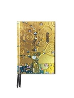
Klimt: Tree Of Life (Foiled Pocket Journal)

Part of a series of handy, luxurious Flame Tree Pocket Books. Combining high-quality production with magnificent fine art, the covers are printed on foil in five colours, embossed then foil stamped. And they`re delightfully practical: a pocket at the back for receipts and scraps, two bookmarks and a solid magnetic side flap. These are perfect for personal use, handbags and make a dazzling gift. This example is based on `Tree of Life` by Gustav Klimt (1862-1918).
RIP - This product is no longer available on our network. It was last seen on 25.09.2019

This page now acts as a permanent archive for this product. Add more information using the comments box below to ensure it can still be found by future generations.

Use our search facility to see if it is available from an alternative contributor.
  • Availability: Out Of Stock
  • Supplier: Stanfords
  • SKU: 9781786640642
Availability: In Stock
£7.99

Product Description

Part of a series of handy, luxurious Flame Tree Pocket Books. Combining high-quality production with magnificent fine art, the covers are printed on foil in five colours, embossed then foil stamped. & they`re delightfully practical: a pocket at the back for receipts & scraps, two bookmarks & a solid magnetic side flap. These are perfect for personal use, handbags & make a dazzling gift. This example is based on ` Tree of Life` by Gustav Klimt (1862-1918).

Reviews/Comments

Add New

Intelligent Comparison

Oooops!
We couldn't find anything!
Perhaps this product's unique.... Or perhaps we are still looking for comparisons!
Click to bump this page and we'll hurry up.

Price History

Vouchers

No voucher codes found.
Do you know a voucher code for this product or supplier? Add it to Insights for others to use.

Facebook

Jargon Buster

Embossed - A raised area of text or print
magnetic - A susbstance affected at a microscopic level by an applied magnetic field.
Gift - Something that is presented without expecting anything in return
Quality - An object that has quality is superior in function and finish than a less quality object.
Practical - Weather a task is easy to carry out and realistically succeed.
Personal - Something that belongs more to an individual due to it affecting them more by relating to them.
Pocket - A bag shaped insert in clothing used to carry items
Solid - Something that is firm and not liquid, a hard shape that cannot be changed easily.

Supplier Information

Stanfords
Stanfords was established in 1853 and opened their iconic Covent Garden flagship store in 1901. They have become the top retailer of maps, travel books and accessories in the UK and arguably offer the largest selection of maps and travel books worldwide. Famous names such as Captain Robert Falcon Scott, Ranulph Fiennes and Michael Palin have purchased from Stanfords. They now have a shop in Bristol and both stores together with other venues operate a calendar of events including talks, book signings and exhibitions. As a specialist map retailer, the map selection is comprehensive and includes road maps, street maps and walking maps from worldwide destinations, as well as a selection of world atlases and wall maps. Books include travel guides and travel literature. Stanfords also stock globes, from miniatures made of blue marble to magnificent floor-standing globes. The website features a selection of interesting articles on travel topics.
Page Updated: 2023-11-12 20:15:36

Community Generated Product Tags

Oh No! The productWIKI community hasn't generated any tags for this product yet!
Menu