More From Contributor
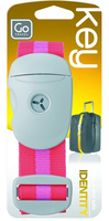
£8.00
The Royal Botanic Gardens, Kew boasts more than 325 acres, more than thirty thousand plant species, & more than 1.35 million visitors a year. With so many sights & more than two centuries of history, the Kew Guide is the perfect introduction for anyone wishing for a memorable visit-and a perfect keepsake for those wanting a memory to take home. This extensive guidebook helps readers discover Kew`s many greenhouses, landscapes, & exhibits while exploring both the scientific & the artistic sides of the gardens. ...
Archived Product
£4.99
Shimmering with colour, this enchanting book will take you on a trip around your garden. You will find tropical plants, delicate water lilies, silky soft badgers & fascinating fungi. Learn how to identify lots of different flowers & plants
- some that can be found in your own garden, & some that can only be found in very special gardens. Activities include: Colour the badger`s home Help the bees through the honeycomb maze Find the ants hiding in the pinecones Match the raw vegetables to the prepared vegetables Match leaves to the trees they fall from Make a beautiful frame of photos from your own garden With charming illustrations on every page & over 300 bright stickers, this book is perfect for children with a budding interest in the outdoors!
...
Archived Product
£30.00
All British Library cushions are printed using archival inks to get the brightest finish possible, with a super soft cotton linen mix, & come complete with the cushion pad washable at 30º. To see other cushion designs in this series please lick on the series link. ...
Archived Product
£3.50
Kew, Gunnerbury & Old Brentford in 1913 in a fascinating series of reproductions of old Ordnance Survey plans in the Alan Godfrey Editions, ideal for anyone interested in the history of their neighbourhood or family. Two versions have been published for this area. The north-western quarter covers Old Brentford, including the High Street (as far west as Smith Hill & the Royal Hotel), with malthouses, a brewery, wharves & the Brentford Ait isl&. East of this is Kew Bridge, the Star & Garter Hotel, Kew Bridge station, Brentford Market. In the north-eastern quarter of the map is Gunnersbury, with Gunnersbury station, High Road, Wellesley Road, leading to part of Turnham Green at the edge of the map. Further south, on the Thames, is Strand on the Green, with boat houses & malthouses, & the map extends south-east to the northern part of Grove Park, including Grove House & Chiswick & Grove Park station. On the Surrey side of the river is Kew, including Kew Green, St Anne`s church, Kew Palace, & much of the Botanic Gardens, as far south as the Palm House. On the reverse there are extracts from early directories. About the Alan Godfrey Editions of the 25” OS Series: Selected towns in Great Britain & Ireland are covered by maps showing the extent of urban development in the last decades of the 19th & early 20th century. The plans have been taken from the Ordnance Survey mapping & reprinted at about 15 inches to one mile (1:4, 340). On the reverse most maps have historical notes & many also include extracts from contemporary directories. Most maps cover about one mile (1.6kms) north/south, one & a half miles (2.4kms) across; adjoining sheets can be combined to provide wider coverage.FOR MORE INFORMATION & A COMPLETE LIST OF ALL AVAILABLE TITLES PLEASE CLICK ON THE SERIES LINK ...
Archived Product
£3.50
Kew, Gunnerbury & Old Brentford in 1894 in a fascinating series of reproductions of old Ordnance Survey plans in the Alan Godfrey Editions, ideal for anyone interested in the history of their neighbourhood or family. Two versions have been published for this area. The north-western quarter covers Old Brentford, including the High Street (as far west as Smith Hill & the Royal Hotel), with malthouses, a brewery, wharves & the Brentford Ait isl&. East of this is Kew Bridge, the Star & Garter Hotel, Kew Bridge station, Brentford Market. In the north-eastern quarter of the map is Gunnersbury, with Gunnersbury station, High Road, Wellesley Road, leading to part of Turnham Green at the edge of the map. Further south, on the Thames, is Strand on the Green, with boat houses & malthouses, & the map extends south-east to the northern part of Grove Park, including Grove House & Chiswick & Grove Park station. On the Surrey side of the river is Kew, including Kew Green, St Anne`s church, Kew Palace, & much of the Botanic Gardens, as far south as the Palm House. On the reverse there are extracts from early directories. About the Alan Godfrey Editions of the 25” OS Series: Selected towns in Great Britain & Ireland are covered by maps showing the extent of urban development in the last decades of the 19th & early 20th century. The plans have been taken from the Ordnance Survey mapping & reprinted at about 15 inches to one mile (1:4, 340). On the reverse most maps have historical notes & many also include extracts from contemporary directories. Most maps cover about one mile (1.6kms) north/south, one & a half miles (2.4kms) across; adjoining sheets can be combined to provide wider coverage.FOR MORE INFORMATION & A COMPLETE LIST OF ALL AVAILABLE TITLES PLEASE CLICK ON THE SERIES LINK ...
Archived Product
£29.00
Self-Drive is the popular alternative to the guided tour safari
- & the freedom it brings to do what you want when you want & stay
...
Archived Product
£9.99
The Kgalagadi Transfrontier Park, both the sections in Botswana & the South Africa, presented at 1:400, 000 on a GPS compatible map from Veronica Roodt Publications, with enlargements for the most visited areas. On one side is a general overview map of the whole park on both sides of Nossob River. Road network shows gravel roads, public 4WD trails, wilderness trails subject to advance booking, & 4WD tracks within the Bitterpan Dune Camp with restrictions on the size of vehicles. Driving distances are marked on all routes. Symbols highlight locations of lodges, camp sites, park entry gates & look-out points. Important locations, including road junctions, are annotated with GPS waypoints. The map also has latitude & longitude lines at intervals of 15’. The base map uses satellite imagery to show the region’s topography. On the reverse are maps, all annotated with GPS coordinates, showing popular areas in greater detail:* in Botswana: the Gemsbok Wilderness Trail & the Swartpan area (1:350, 000), the Mabuasehube area (1:150, 000), plus the Mabuasehube to Nossop Wilderness Trail (1:600, 000)* in South Africa: the whole of the South African section at 1:200, 000 Also provided are notes about the park regulations with contact details, general information about the park, plus a separate panel with a map the Kaa Kalahari Concession. Current edition of this map was published in 2004. ...
Archived Product
£13.95
Khabarovsk Krai Road Atlas in a series of detailed atlases of the administrative provinces of the Russian Federation from Roskartografia, with road information shown on a topographic base. Road network

Includes::
minor local roads, service stations, & distances between junctions. Colour coding distinguishes between federal roads & those which are the responsibility of local government. In many areas tracks & footpaths are included. The atlases also show railway lines, as well as inland waterways with locations of locks & the direction of the current. Cities & towns are marked according to the size of their population. Symbols indicate natural landmarks, post offices, hospitals & other facilities, museums, monuments, etc. Topography is shown by contours at 100m intervals & spot heights. Each atlas has an index &

Includes::
an administrative map of the region & a key to Russian road signs. In some atlases coverage is provided only for the areas with roads & not for the whole province. Please see individual descriptions or images of the area coverage supplied with each title. All place names are in the Cyrillic alphabet & the text, including map legends, is in Russian only. In this title: basic street plans of Khabarovsk at 1:120, 000 & Komsomolsk-na-Amure at 1:110, 000.IMPORTANT
- PLEASE NOTE BEFORE ORDERING: Supplies are very erratic & no delivery date can be guaranteed for titles currently not in stock. Also, we occasionally receive copies with different covers or in different sizes to those indicated on our website. But the cartography & basic information remains as described above.


...
Archived Product
£9.99
Khadachakra, sheet no. 2981-15, in the topographic survey of Nepal at 1:50, 000 published by the Nepali Government in the late 1990s & early 2000s & produced from remote sensing data by Finnish cartographers as part of that country’s international aid program. The maps cover 15’ x 15’ quadrangles.IMPORTANT – PLEASE NOTE BEFORE ORDERING: AVAILABILITY: although, theoretically at least, still in print, these maps are very difficult to get locally in Nepal and/or from various suppliers elsewhere specializing in obtaining such maps. DELIVERIES MAY TAKE SEVERAL WEEKS OR EVEN MONTHS.PROBLEMS WITH PLACE NAMES: reports from previous users indicate that transliteration of place names differs from that used widely not only on other maps & in guide books but also on the ground itself, in road signs & in the tourist & trekking industry in general. Whilst most names are similar enough to be easily recognizable, e.g. Namche Bajar for Namche Bazar or Lantan for Langtang, we have been told of confusion & difficulties arising from different spellings appearing on these maps.TREKKING ROUTES & TOURIST INFORMATION: whilst the maps show foot trails & mark locations of temples, etc, they carry no specific trekking information. Major trekking routes & places of interest are not highlighted. There is no marking for base camps & other tourist facilities. Map specifications: Contours are at 40m intervals, with graphics and/or coloring to show various features of the terrain (glaciers with moraines & crevasses, quarries, gravel or clay pits, etc.) & vegetation (forests, bush, grass, orchards & plantations, etc). Additional comments such as “open mixed forest mainly bajh & pine” annotate many area. The maps have numerous spot heights, but relatively few peaks are named. Areas outside the country’s borders are left blank. Settlements in remote areas are indicated by markings for individual buildings & the placing of names does not always make it clear which group of buildings they refer to. Road network distinguishes between major & minor foot trails. Symbols mark features such as temples, schools & hospitals, police stations, etc. Also shown are the country’s administrative divisions. The maps have a 1-km UTM grid, plus latitude & longitude lines at intervals of 5’. Map legend & all the text is in English. Coverage: the whole country is now covered, with the north at 1:50, 000, plus central & southern Nepal at 1:25, 000. The two series are complementary, do not overlap & use the same grid & numbering system (apart from the Lumbini Zone, where a different grid & numbering are used). For areas not shown on our grid & titles not listed here, please contact us by e-mail, but please do bear in mind the problems with availability & the likely very long delivery time. ...
Archived Product
£9.99
Khalanga Baja (Darchula), sheet no. 2980-03 / 3080-15, in the topographic survey of Nepal at 1:50, 000 published by the Nepali Government in the late 1990s & early 2000s & produced from remote sensing data by Finnish cartographers as part of that country’s international aid program. The maps cover 15’ x 15’ quadrangles.IMPORTANT – PLEASE NOTE BEFORE ORDERING: AVAILABILITY: although, theoretically at least, still in print, these maps are very difficult to get locally in Nepal and/or from various suppliers elsewhere specializing in obtaining such maps. DELIVERIES MAY TAKE SEVERAL WEEKS OR EVEN MONTHS.PROBLEMS WITH PLACE NAMES: reports from previous users indicate that transliteration of place names differs from that used widely not only on other maps & in guide books but also on the ground itself, in road signs & in the tourist & trekking industry in general. Whilst most names are similar enough to be easily recognizable, e.g. Namche Bajar for Namche Bazar or Lantan for Langtang, we have been told of confusion & difficulties arising from different spellings appearing on these maps.TREKKING ROUTES & TOURIST INFORMATION: whilst the maps show foot trails & mark locations of temples, etc, they carry no specific trekking information. Major trekking routes & places of interest are not highlighted. There is no marking for base camps & other tourist facilities. Map specifications: Contours are at 40m intervals, with graphics and/or coloring to show various features of the terrain (glaciers with moraines & crevasses, quarries, gravel or clay pits, etc.) & vegetation (forests, bush, grass, orchards & plantations, etc). Additional comments such as “open mixed forest mainly bajh & pine” annotate many area. The maps have numerous spot heights, but relatively few peaks are named. Areas outside the country’s borders are left blank. Settlements in remote areas are indicated by markings for individual buildings & the placing of names does not always make it clear which group of buildings they refer to. Road network distinguishes between major & minor foot trails. Symbols mark features such as temples, schools & hospitals, police stations, etc. Also shown are the country’s administrative divisions. The maps have a 1-km UTM grid, plus latitude & longitude lines at intervals of 5’. Map legend & all the text is in English. Coverage: the whole country is now covered, with the north at 1:50, 000, plus central & southern Nepal at 1:25, 000. The two series are complementary, do not overlap & use the same grid & numbering system (apart from the Lumbini Zone, where a different grid & numbering are used). For areas not shown on our grid & titles not listed here, please contact us by e-mail, but please do bear in mind the problems with availability & the likely very long delivery time. ...
Archived Product

Key Strap (40mm)

Bright 4cm luggage strap with the added security of being locked, with this bright strap on your case you will identify your luggage in seconds and also have the peace of mind you wont be seeing your clothes whizzing around the carousel.Available in assorted colours:- Yellow & Dark Yellow- Purple & Light Purple- Pink & Light Pink- Light Blue & Orange
RIP - This product is no longer available on our network. It was last seen on 25.09.2019

This page now acts as a permanent archive for this product. Add more information using the comments box below to ensure it can still be found by future generations.

Use our search facility to see if it is available from an alternative contributor.
  • External links may include paid for promotion
  • Availability: Out Of Stock
  • Supplier: Stanfords
  • SKU: 5016326002241
Availability: In Stock
£6.99

Product Description

Bright 4cm luggage strap with the added security of being locked, with this bright strap on your case you will identify your luggage in seconds & also have the peace of mind you wont be seeing your clothes whizzing around the carousel. Available in assorted colours:- Yellow & Dark Yellow- violet & Light violet- Pink & Light Pink- Light Blue & Orange

Reviews/Comments

Add New

Intelligent Comparison

Oooops!
We couldn't find anything!
Perhaps this product's unique.... Or perhaps we are still looking for comparisons!
Click to bump this page and we'll hurry up.

Price History

Vouchers

No voucher codes found.
Do you know a voucher code for this product or supplier? Add it to Insights for others to use.

Facebook

Jargon Buster

Blue - A primary colour
Pink - A colour made by combining red and white
Yellow - A primary colour. The sun is often described as yellow
Purple - A colour between red and blue. Commonly associated with Cadburys
Key - A physical or virtual device or code used for opening something
Dark - A colour which absorbs visable ligt so apears less light than objects that reflect light
40mm - The equivilent of 4cm

Supplier Information

Stanfords
Stanfords was established in 1853 and opened their iconic Covent Garden flagship store in 1901. They have become the top retailer of maps, travel books and accessories in the UK and arguably offer the largest selection of maps and travel books worldwide. Famous names such as Captain Robert Falcon Scott, Ranulph Fiennes and Michael Palin have purchased from Stanfords. They now have a shop in Bristol and both stores together with other venues operate a calendar of events including talks, book signings and exhibitions. As a specialist map retailer, the map selection is comprehensive and includes road maps, street maps and walking maps from worldwide destinations, as well as a selection of world atlases and wall maps. Books include travel guides and travel literature. Stanfords also stock globes, from miniatures made of blue marble to magnificent floor-standing globes. The website features a selection of interesting articles on travel topics.
Page Updated: 2023-11-12 20:15:36

Community Generated Product Tags

Oh No! The productWIKI community hasn't generated any tags for this product yet!
Menu