
 United Kingdom
 France
 Germany
 Netherlands
 Sweden
 USA
USA
 Italy
Italy
 Spain
Spain
More From Contributor


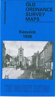
Keswick 1898
Keswick in 1898 in a fascinating series of reproductions of old Ordnance Survey plans in the Alan Godfrey Editions, ideal for anyone interested in the history of their neighbourhood or family. The map is double-sided. The main map covers the town centre, extending southward to Derwent Isle and westward to the western bank of Derwent Water. Features include northern part of Derwent Water, landing stages, Galemire Bay, Lingholme Islands, Isthmus Bay, Castlehead Wood, St John`s church, Upper Fitz Park, Castlerigg Manor, Crow Park, Market Place, Market Square, Greta Pencil Works, George Hotel, etc. On the reverse is about half of the adjacent sheet 64.02 extending coverage northward to include railway with station, coal depot, Keswick Hotel, Brigham, Lower Fitz Park, High
Hill, Great Crosthwaite, Lairthwaite, Mary Hewetson Hospital and Gretabank Farm. About the Alan Godfrey Editions of the 25” OS Series:Selected towns in Great Britain and Ireland are covered by maps showing the extent of urban development in the last decades of the 19th and early 20th century. The plans have been taken from the Ordnance Survey mapping and reprinted at about 15 inches to one mile (1:4, 340). On the reverse most maps have historical notes and many also include extracts from contemporary directories. Most maps cover about one mile (1.6kms) north/south, one and a half miles (2.4kms) across; adjoining sheets can be combined to provide wider coverage.FOR MORE INFORMATION AND A COMPLETE LIST OF ALL AVAILABLE TITLES PLEASE CLICK ON THE SERIES LINK.
Hill, Great Crosthwaite, Lairthwaite, Mary Hewetson Hospital and Gretabank Farm. About the Alan Godfrey Editions of the 25” OS Series:Selected towns in Great Britain and Ireland are covered by maps showing the extent of urban development in the last decades of the 19th and early 20th century. The plans have been taken from the Ordnance Survey mapping and reprinted at about 15 inches to one mile (1:4, 340). On the reverse most maps have historical notes and many also include extracts from contemporary directories. Most maps cover about one mile (1.6kms) north/south, one and a half miles (2.4kms) across; adjoining sheets can be combined to provide wider coverage.FOR MORE INFORMATION AND A COMPLETE LIST OF ALL AVAILABLE TITLES PLEASE CLICK ON THE SERIES LINK.

Product Description
Reviews/Comments
Add New
Intelligent Comparison
Archived Product
Elswick 1894 Stanfords
£3.50
Archived Product
Chiswick 1893 Stanfords
£3.50
Vouchers
No voucher codes found.
Do you know a voucher code for this product or supplier? Add it to Insights for others to use.
Do you know a voucher code for this product or supplier? Add it to Insights for others to use.
 Denmark