More From Contributor
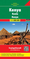
£3.50
Kenwood & Golders Hill in 1894 in a fascinating series of reproductions of old Ordnance Survey plans in the Alan Godfrey Editions, ideal for anyone interested in the history of their neighbourhood or family. The map covers an area still largely rural in 1894, stretching from Finchley Road eastward to Kenwood House. To the south is part of Hampstead Heath with The Spaniards Inn, Kenwood House itself, Ken Wood & North End. Golders Hill is covered & North End Road, but beyond this is rural Middlesex including Bishop`s Wood, Turner`s Wood & Wild Hatch. On the reverse the eastern half of the map is shown revised to 1912. This is busier, showing development north of Golders Hill Park including Golders Green station, West Heath Avenue, North End Road, Hampstead Way, Jews’ Cemetery & railway works, providing a fascinating contrast with the 1894 version. About the Alan Godfrey Editions of the 25” OS Series: Selected towns in Great Britain & Ireland are covered by maps showing the extent of urban development in the last decades of the 19th & early 20th century. The plans have been taken from the Ordnance Survey mapping & reprinted at about 15 inches to one mile (1:4, 340). On the reverse most maps have historical notes & many also include extracts from contemporary directories. Most maps cover about one mile (1.6kms) north/south, one & a half miles (2.4kms) across; adjoining sheets can be combined to provide wider coverage.FOR MORE INFORMATION & A COMPLETE LIST OF ALL AVAILABLE TITLES PLEASE CLICK ON THE SERIES LINK. ...
Archived Product
£4.99
Kenya at 1:1, 300, 000 is an indexed tourist map of the country with additional street plans & enlargements of some national parks, reserves & popular regions. Road detail distinguishes untarred roads &

Includes::
selected tracks & minor roads, & shows intermediate driving distances on main routes. Some petrol stations are also indicated, & railways & airports are marked. The publisher

...
Archived Product
£11.95
Kenya at 1:1, 000, 000 from Mair Dumont with road & rail networks presented on a base with plenty of topographic information, plus an extensive index which also

Includes::
natural features such are national parks, rivers, mountain chains, etc. Maps in the Mair Dumont

...
Archived Product
£13.59
Kenya in the Countries & Regions series from Lonely Planet, market-leading comprehensive guides aimed at independent travellers & serving a large range of international destinations. Frank & informal in style, the guides explore an extensive range of sights, activities, accommodation, restaurants & nightlife & are designed for practical use while travelling on the road. Written & researched by a team of experts, each book is independent in its recommendations & suggestions, often offering individual takes on individual destinations. Widely recognised for their reliability, each Lonely Planet country & region guide has the same layout. Introductory sections profile the destination with individual chapters on particular highlights, getting started, (including when to go) itineraries, history, culture, arts, food & drink & the environment. Each guide is organised geographically by region, with individual sections detailing an extensive range of sights, places of interest, attractions, restaurants, nightlife, accommodation & any local activities. The guides have detailed explanations of historical context where relevant. There is also practical guidance on ...
Archived Product
£13.59
Kenya in the Countries, Regions & Cities series from Rough Guides; comprehensively detailed guidebooks specifically designed for independent travellers & serving a range of worldwide destinations. Widely recognised for their free editorial style, Rough Guide authors are allowed to express their personal opinions on a range of subjects. Although sometimes controversial, this editorial stance allows readers to experience more detailed & personal takes on each destination, a feature often more limited in other guidebooks. Cultural & historical nuances are explored in significant depth throughout the text & descriptions on the ambience of individual settings alongside personal recommendations, particularly in cities, are notably prevalent. Each Rough Guide in the Countries, Regions & Cities series has a similar layout. A ...
Archived Product
£4.99
The highly successful Globetrotter Travel Series, which

Includes::
Travel Guides, Travel Maps, Road Atlases,

...
Archived Product
£11.99
Kenya at 1:1, 000, 000 from Mair Dumont with road & rail networks presented on a base with plenty of topographic information, plus an extensive index which also

Includes::
natural features such are national parks, rivers, mountain chains, etc. Maps in the Mair Dumont’s Marco Polo series have a special fold-out flap in the jacket providing an overview of the whole area covered by the map plus the adjoining regions & highlighting popular locations, with the grid reference system in the margins making it easier to find places on the main map. A set of seven peel-on/peel-off stickers, removable without damaging the map surface, is provided for making selected locations more prominent when navigating. Coverage extends south to include the main national parks of northern Tanzania, including Kilimanjaro, Arusha, & most of Serengeti & Ngorongoro. Topography is shown by relief shading with spot heights & plenty of names of mountain ranges, peaks, plateaux, deserts, etc. Locations of interest are prominently highlighted, with separate colouring for towns & villages & for natural features including hot springs, waterfalls, gorges, etc. National parks & other protected areas are marked & symbols indicate various types of tourist accommodation, beaches & diving sites, etc. Adjoining areas of neighbouring countries are similarly presented. Road network indicates unsurfaced roads & indicates tracks difficult to use outside the dry season. Scenic roads are highlighted & driving distances are given on main routes & on many connecting roads. Railways lines, local airports & internal administrative boundaries are also shown. The map has latitude & longitude lines at intervals of 1º. * Multilingual map legend

Includes::
English.* Extensive index is in a separate 12-page booklet attached to the map cover & lists town & villages plus natural

Features:
rivers, lakes, mountains, etc. Also provided are a separate list of World Heritage Sites & a list of national parks, plus a distance table.


...
Archived Product
£13.59
Kenya in the Countries & Regions series from Lonely Planet, market-leading comprehensive guides aimed at independent travellers & serving a large range of international destinations. Frank & informal in style, the guides explore an extensive range of sights, activities, accommodation, restaurants & nightlife & are designed for practical use while travelling on the road. Written & researched by a team of experts, each book is independent in its recommendations & suggestions, often offering individual takes on individual destinations. Widely recognised for their reliability, each Lonely Planet country & region guide has the same layout. Introductory sections profile the destination with individual chapters on particular highlights, getting started, (including when to go) itineraries, history, culture, arts, food & drink & the environment. Each guide is organised geographically by region, with individual sections detailing an extensive range of sights, places of interest, attractions, restaurants, nightlife, accommodation & any local activities. The guides have detailed explanations of historical context where relevant. There is also practical guidance on ...
Archived Product
£16.99
Kenya in the Countries, Regions & Cities series from Rough Guides; comprehensively detailed guidebooks specifically designed for independent travellers & serving a range of worldwide destinations. Widely recognised for their free editorial style, Rough Guide authors are allowed to express their personal opinions on a range of subjects. Although sometimes controversial, this editorial stance allows readers to experience more detailed & personal takes on each destination, a feature often more limited in other guidebooks. Cultural & historical nuances are explored in significant depth throughout the text & descriptions on the ambience of individual settings alongside personal recommendations, particularly in cities, are notably prevalent. Each Rough Guide in the Countries, Regions & Cities series has a similar layout. A ...
Archived Product
£25.00
On December 12, 1963, people across Kenya joyfully celebrated independence from British colonial rule, anticipating a bright future of prosperity & social justice. As the nation approaches the fiftieth anniversary of its independence, however, the people`s dream remains elusive. During its first five decades Kenya has experienced assassinations, riots, coup attempts, ethnic violence, & political corruption. The ranks of the disaffected, the unemployed, & the poor have multiplied. In this authoritative & insightful account of Kenya`s history from 1963 to the present day, Daniel Branch sheds new light on the nation`s struggles & the complicated causes behind them. Branch describes how Kenya constructed itself as a state & how ethnicity has proved a powerful force in national politics from the start, as have disorder & violence. He explores such divisive political issues as the needs of the landless poor, international relations with Britain & with the Cold War superpowers, & the direction of economic development. Tracing an escalation of government corruption over time, the author brings his discussion to the present, paying particular attention to the rigged election of 2007, the subsequent compromise government, & Kenya`s prospects as a still-evolving independent state. ...
Archived Product

Kenya

Indexed, waterproof and tear-resistant road map of Kenya at 1:950, 000 with topographic and tourist information, published by Reise Know-How as part of their highly acclaimed World Mapping Project. The map is double-sided to provide the best balance between a good scale and a convenient size sheet. The country is divided into north/south with a generous overlap between the sides and coverage includes parts of northern Tanzania with Kilimanjaro and Arusha National Parks, also most of the Serengeti National Park and the Ngorongoro Conservations Area.Topography is presented by altitude colouring with contours and spot height, plus names of various mountain ranges, peaks, etc. Seasonal water features, swamps, salt lakes and mangroves are indicated. National parks, reversves and other
protected areas are prominently highlighted. Road network includes unsurfaced local roads and seasonal tracks, and indicates driving distances on main and secondary roads and locations of petrol stations. Border crossings are clearly marked. Railways and local airfields are also shown and internal administrative boundaries are presented with names of the provinces. Symbols highlight various places of interest, including selected hotels, campsites and lodges, viewpoints, archaeological sites, rock paintings, waterholes and hot springs, beaches and diving sites, etc. The map has a latitude and longitude grid at intervals of at 1
RIP - This product is no longer available on our network. It was last seen on 25.09.2019

This page now acts as a permanent archive for this product. Add more information using the comments box below to ensure it can still be found by future generations.

Use our search facility to see if it is available from an alternative contributor.
  • External links may include paid for promotion
  • Availability: Out Of Stock
  • Supplier: Stanfords
  • SKU: 9783831771226
Availability: In Stock
£9.50

Product Description

Indexed, waterproof & tear-resistant road map of Kenya at 1:950, 000 with topographic & tourist information, published by Reise Know-How as part of their highly acclaimed World Mapping Project. The map is double-sided to provide the best balance between a good scale & a convenient size sheet. The country is divided into north/south with a generous overlap between the sides & coverage

Includes::
parts of northern Tanzania with Kilimanjaro & Arusha National Parks, also most of the Serengeti National Park & the Ngorongoro Conservations Area. Topography is presented by altitude colouring with contours & spot height, plus names of various mountain ranges, peaks, etc. Seasonal water features, swamps, salt lakes & mangroves are indicated. National parks, reversves & other protected areas are prominently highlighted. Road network

Includes::
unsurfaced local roads & seasonal tracks, & indicates driving distances on main & secondary roads & locations of petrol stations. Border crossings are clearly marked. Railways & local airfields are also shown & internal administrative boundaries are presented with names of the provinces. Symbols highlight various places of interest, including selected hotels, campsites & lodges, viewpoints, archaeological sites, rock paintings, waterholes & hot springs, beaches & diving sites, etc. The map has a latitude & longitude grid at intervals of at 1

Reviews/Comments

Add New

Price History

Vouchers

No voucher codes found.
Do you know a voucher code for this product or supplier? Add it to Insights for others to use.

Facebook

Jargon Buster

water - A chemical substance. Chemical formula H2O.
hot - An indication of the temperature being high and a sensation of heat to the tough
Waterproof - Resistant to water, usualy specified by depth in metres
Railways - A set of tracks that have been laid for the purpose of trains to travel up and down them
World - A physical grouping, commonly used to describe earth and everything associated with ti
Size - is the measurement of how big an object is in space.
Network - A link and communication between things. Often computers or people.
Road - a manmade lane or a path that is used to speed up travel.
Resistant - Something that can repel against something.
Altitude - Something that can be quite high in relation to sea or ground level.
Balance - Something that is evenly weighted to keep something upright.
Convenient - Something that suits and fits well to other activities.

Supplier Information

Stanfords
Stanfords was established in 1853 and opened their iconic Covent Garden flagship store in 1901. They have become the top retailer of maps, travel books and accessories in the UK and arguably offer the largest selection of maps and travel books worldwide. Famous names such as Captain Robert Falcon Scott, Ranulph Fiennes and Michael Palin have purchased from Stanfords. They now have a shop in Bristol and both stores together with other venues operate a calendar of events including talks, book signings and exhibitions. As a specialist map retailer, the map selection is comprehensive and includes road maps, street maps and walking maps from worldwide destinations, as well as a selection of world atlases and wall maps. Books include travel guides and travel literature. Stanfords also stock globes, from miniatures made of blue marble to magnificent floor-standing globes. The website features a selection of interesting articles on travel topics.
Page Updated: 2023-11-12 20:15:36

Community Generated Product Tags

Oh No! The productWIKI community hasn't generated any tags for this product yet!
Menu