
 United Kingdom
 France
 Germany
 Netherlands
 Sweden
 USA
USA
 Italy
Italy
 Spain
Spain
More From Contributor


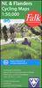
Kempen Region Of The Antwerp Province Cycling Map
The Antwerp province of Belgium at 1:50, 000 in a series from Falk B.V. showing the network of signposted cycling routes on large, double-sided indexed maps with prominent highlighting of long-distance LF routes, symbols indicating accommodation and other tourist services, plus in each title two or more panels with recommended local circuits and additional tourist information. The Falk 50K cycling series, which includes some adjoining areas in Lower Saxony and has now been extended to cover Flanders, shows the extensive network of sign-posted cycling routes. The network consists of numbered junctions joined by sign-posted connecting routes in either direction. At each junction there is an information panel showing an overview map of the whole network with the junction numbers. A
second panel shows all the intersections directly connected to that junction. The system enables cyclists to plan their own routes by preparing a list of junction numbers through which they want to travel.Falk maps give cycling distances between the junctions and indicate which roads, both within the numbered network and outside it, have separate cycling paths. Routes which are part of the LF network of long-distance cycle routes are clearly marked. A wide range of symbols shows various accommodation options, bars and restaurants, and various places of interest. Landscape information is provided by colouring for woodlands, dunes, etc. The maps are indexed and show in the margins latitude and longitude at 1`52” intervals. Map legend includes English.PLEASE NOTE: to see other titles
in the Falk series please click on the series link, where the series description includes a comparison between the Falk maps and the ANWB cycling series also covering the Netherlands at 1:50, 000.
Product Description
Reviews/Comments
Add New
Vouchers
No voucher codes found.
Do you know a voucher code for this product or supplier? Add it to Insights for others to use.
Do you know a voucher code for this product or supplier? Add it to Insights for others to use.
 Denmark