More From Contributor
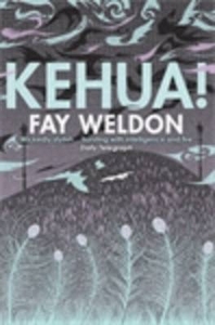
£10.99
In 1996, in the middle of watching an ill-tempered football match between England & Germany, Philip Oltermann`s parents tell him that they are going to leave their home city Hamburg behind & move to London. A number of worrying questions arise. How would English schoolboys take to a lanky 16-year-old German? How did they think & do things differently? What was the secret of the famed British humour? & were there values that English & German people shared? In search of answers, Oltermann interweaves memoir & history, taking ten key Anglo-German encounters from the last 200 years as his starting point. These include: an encounter between Joe Strummer & the Baader Meinhof gang, Helmut Kohl trying to explain the virtues of German cuisine to a sceptical Margaret Thatcher & philosophers Theodor Adorno & A. J. Ayer clashing over jazz. What emerges is nothing less than an alternative national story for the two countries: not one marked by military conflict & diplomatic hostility, but one shaped by dialogue, interaction & genuine fondness. ...
Archived Product
£6.95
Kefalonia at 1:65, 000 with Ithaca at 1:25, 000 on a contoured, GPS compatible double-sided map from a wide coverage of the Greek islands by Anavasi, printed on light, waterproof & tear-resistant plastic paper. On one side are both islands presented at 1:65, 000, with an enlargement of Ithaca to 1:25, 000 shown on the reverse. Contours at 20m intervals are enhanced by relief shading & spot heights, with graphics indicating different types of vegetation: forests, shrubbery, olive groves & vineyards. Road network indicates dirt roads in poor condition or difficult roads, & shows locations of petrol stations & driving distances on main routes. Also marked are country trails ranging from narrow earth roads to faintly defined paths. Symbols mark various places of interest. The maps have a UTM grid for GPS use & latitude/longitude margin ticks. All place names are in both Greek & Latin alphabet, as are the indexes for each isl&. Map legends include English. (Kefallonia, Kefallinia, Cephalonia, Cefalonia, Ithaka, Ithaki) ...
Archived Product
£10.99
Kefalonia & Ithaca at 1:50, 000 on a large, clear map of the two islands, plus a street plan of Argostoli. Place names are shown in both Greek & Latin alphabet. Locations of campsites & various places of interest are highlighted, & local beaches are prominently marked. Road network

Includes::
selected country paths & gives locations of petrol stations & driving distances. Ferry routes are also marked. Topography is shown by relief shading, with colouring for woodlands. The map has latitude & longitude lines at intervals of 5’. Also provided is a street plan of Argostoli with names of selected streets shown in Latin alphabet. (Kefallonia, Kefallinia, Cephalonia, Cefalonia, Ithaka, Ithaki)

...
Archived Product
£8.99
If holidays are about new experiences, then this pocket guide solves two problems — where to enjoy walking in Kefalonia & where to find some good, traditional food. There are strolls for hot days & longer walks to work up an appetite. & if you‘re just after some recommendations for where to eat out in Kefalonia, you need look no further! For each suggested restaurant there is a photograph of the décor & one of their dishes, plus sample menu, price guide, opening times, & a recipe for one of their specialities. Other sections include: planning your trip, logistics on arrival, shopping for self-catering (including health food shops), local markets & specialities, glossary of local food terms, etc. A special feature is the emphasis on natural local foods suitable for those with food intolerances. All recipes have been made by the authors & are known to ‘work’. Area covered: The walks are spread all around the island & there is at least one near every major resort. There isn’t much information available for walking on the isl&, & this book brings together ten of Kefalonia’s best walks. The best months for walking in Kefalonia are from early April to end May & late September till October. ...
Archived Product
£19.95
One of the titles in the 1:50, 000 topographic survey of Icel&. The series is not complete. So far 102 maps have been published, out of the total of 199, with the north-west & the east of the country not yet covered. The series has been compiled from aerial photography & has contours at 20m intervals. The maps do not give as much information on the type of the terrain & land use as the 1:100, 000 series, but the cartography

Includes::
many other

Features:
hot & cold springs & wells, streams graded by width, etc. Each map covers an area of Approx. 23 x 28 km / 14 x 17 miles. The maps have a UTM grid, with margin ticks showing latitude & longitude in steps of 5'. Map legend

Includes::
English.


...
Archived Product
£29.99
Map No. 3228, Kei Mouth, in South Africa’s official topographic survey at 1:250, 000 from the country’s national survey organization, the Chief Directorate of Surveys & Mapping. The maps have altitude colouring & contours at 50m or 100m intervals, depending on the map edition, plus spot heights. Deserts, marshes, dry pans, perennial & seasonal water features, etc, as well as protected areas are shown. The maps present the country’s road & rail networks & include the usual information expected on topographic mapping at this scale, although in more rapidly developing areas road information may not necessarily be up to date. Also indicated are magisterial district & provincial boundaries. Latitude & longitude values are shown in the margins at 5` intervals together with South African grid co-ordinates. Typically, each sheet covers an area of one degree of latitude & two degrees of longitude. The projection used is Gauss Conformal. The legend is in English & Afrikaans. ...
Archived Product
£8.99
Keighley & Haworth in the Cassini Past & Present map series which covers town & cities of England & Wales & offers a unique way of tracing their history & expansion by showing four different periods of their development using Ordnance Survey mapping from the mid-19th century, the late 19th century, the 1920s & the present day. Coverage

Includes::
Cullingworth, Denholme, Glusburn, Oxenhope, Silsden, Steeton & Sutton-in-Craven. Each Past & Present map consists of four panels, all centred on a city or a town & covering exactly the same 15km x 15km area. Three of the panels reproduce Ordnance Survey

...
Archived Product
£3.50
Keighley North in 1913 in a fascinating series of reproductions of old Ordnance Survey plans in the Alan Godfrey Editions, ideal for anyone interested in the history of their neighbourhood or family. The map covers the northern half of Keighley, extending from Town Hall Square northward to Keighley Cemetery, & from Cartmel Road eastward to Thwaites House. A small part of Riddlesden, including West Riddlesden Hall, is in the top right corner. Features include the railway station, Devonshire Park, Cliffe Castle, Beechcliffe, Victoria Hospital, Mechanics Institute, tramways, Cavendish Street, Spring Gardens Lane, Burlington Shed, Eastwood, Strong Close, Aireworth, Aireworth Mills, Dalton Mills, Midland Works, Stockbridge Mills, Victoria Park, Thwaites station, the Stock Bridge, Stockbridge, Leeds & Liverpool Canal, etc. A list of private residents from an 1889 directory is on the reverse. About the Alan Godfrey Editions of the 25” OS Series: Selected towns in Great Britain & Ireland are covered by maps showing the extent of urban development in the last decades of the 19th & early 20th century. The plans have been taken from the Ordnance Survey mapping & reprinted at about 15 inches to one mile (1:4, 340). On the reverse most maps have historical notes & many also include extracts from contemporary directories. Most maps cover about one mile (1.6kms) north/south, one & a half miles (2.4kms) across; adjoining sheets can be combined to provide wider coverage.FOR MORE INFORMATION & A COMPLETE LIST OF ALL AVAILABLE TITLES PLEASE CLICK ON THE SERIES LINK. ...
Archived Product
£3.50
Keighley South in 1913 in a fascinating series of reproductions of old Ordnance Survey plans in the Alan Godfrey Editions, ideal for anyone interested in the history of their neighbourhood or family. The map covers southern Keighley, including much of the town centre, from the southern tip of Keighley station southward to Ingrow station (bottom left corner) & eastward to Thwaites Brow. Much of the town`s industrial heritage is shown, including Ingrow Mills, Prospect Mill, Beech Mills, Knowle Mill, Greengate Mills, Crown iron works, Walk Mills, Anchor Iron Works, North Brook iron works, Devonshire Mills, Springfield Mills, North Beck Mills, Low Mill, Devonshire Works, Worth Valley Tool Works, etc. The Midland Railway`s Worth Valley Branch is shown as far as Ingrow station, together with the parallel GNR line, with Ingrow station, engine shed & goods station. Features within the town centre include St Andrew`s church, High Street, Low Street, tramways, Holy Croft, Greengate, Park Wood Bottom, etc. Eastward the map rises up to Thwaites Brow & Long Lee. On the reverse is a list of private residents from a 1917 directory. About the Alan Godfrey Editions of the 25” OS Series: Selected towns in Great Britain & Ireland are covered by maps showing the extent of urban development in the last decades of the 19th & early 20th century. The plans have been taken from the Ordnance Survey mapping & reprinted at about 15 inches to one mile (1:4, 340). On the reverse most maps have historical notes & many also include extracts from contemporary directories. Most maps cover about one mile (1.6kms) north/south, one & a half miles (2.4kms) across; adjoining sheets can be combined to provide wider coverage.FOR MORE INFORMATION & A COMPLETE LIST OF ALL AVAILABLE TITLES PLEASE CLICK ON THE SERIES LINK. ...
Archived Product
£10.99
Keir Hardie was a founder & the first parliamentary leader of the Labour Party. At the turn of the 19th century he was Labour`s most famous face. But despite being voted Labour`s ` Greatest Hero` at the 2008 Party Conference, in recent years his extraordinary story seems all but forgotten. Born illegitimate just outside Glasgow in 1856, his life didn`t start gently. Before the age of 10, he was the sole wage earner in his working class, atheist family. He never went to school but was self-taught, avidly reading books lent him by a kind young clergyman. This led to two major conversions in his life: first to Christianity, & then to socialism. While earlier biographies have neglected the former, pointing out his experience of hardship as the source of his passion for social justice, the role of Christianity in Hardie`s life was profound. It shaped his involvement in many of the greatest social changes of the time. ...
Archived Product

Kehua

Your writer, in conjuring this tale of murder, adultery, incest, ghosts, redemption and remorse, takes you first to a daffodil-filled garden in Highgate, North London, where, just outside the kitchen window, something startling shimmers on the very edges of perception. Fluttering and chattering, these are our kehua - a whole multiplying flock of Maori spirits (all will be explained) goaded into wakefulness by the conversation within. Scarlet - a long-legged, skinny young woman of the new world order - has announced to Beverley - her aged grandmother - that she intends to leave home and husband for the glamorous actor, Jackson Wright - he of the vampire films. Beverley may be well on her way to her ninth decade, but she`s not beyond using this intelligence to stir up a little
trouble. And neither are the kehua outside the window. The sins and traumas of the past haunt us all. Call them hungry ghosts, grateful dead, dybbuks, kelpies, poltergeists, furies or kehua, we carry them with us - across continents, oceans, decades and generations. Quite how they became attached to a three-year-old white girl is the origin of your writer`s tale.Suffice to say that murder is at the root of it all, that Beverley and her female bloodline carry a weighty spiritual burden and that this is the story of how they learn to live with their ghosts, or maybe how their ghosts learn to live with them -
RIP - This product is no longer available on our network. It was last seen on 25.09.2019

This page now acts as a permanent archive for this product. Add more information using the comments box below to ensure it can still be found by future generations.

Use our search facility to see if it is available from an alternative contributor.
  • External links may include paid for promotion
  • Availability: Out Of Stock
  • Supplier: Stanfords
  • SKU: 9781848874602
Availability: In Stock
£7.99

Product Description

Your writer, in conjuring this tale of murder, adultery, incest, ghosts, redemption & remorse, takes you first to a daffodil-filled garden in Highgate, North London, where, just outside the kitchen window, something startling shimmers on the very edges of perception. Fluttering & chattering, these are our kehua
- a whole multiplying flock of Maori spirits (all will be explained) goaded into wakefulness by the conversation within. Scarlet
- a long-legged, skinny young woman of the new world order
- has announced to Beverley
- her aged grandmother
- that she intends to leave home & husband for the glamorous actor, Jackson Wright
- he of the vampire films. Beverley may be well on her way to her ninth decade, but she`s not beyond using this intelligence to stir up a little trouble. & neither are the kehua outside the window. The sins & traumas of the past haunt us all. Call them hungry ghosts, grateful dead, dybbuks, kelpies, poltergeists, furies or kehua, we carry them with us
- across continents, oceans, decades & generations. Quite how they became attached to a three-year-old white girl is the origin of your writer`s tale. Suffice to say that murder is at the root of it all, that Beverley & her female bloodline carry a weighty spiritual burden & that this is the story of how they learn to live with their ghosts, or maybe how their ghosts learn to live with them -

Reviews/Comments

Add New

Intelligent Comparison

Oooops!
We couldn't find anything!
Perhaps this product's unique.... Or perhaps we are still looking for comparisons!
Click to bump this page and we'll hurry up.

Price History

Vouchers

No voucher codes found.
Do you know a voucher code for this product or supplier? Add it to Insights for others to use.

Facebook

Jargon Buster

White - A colour combining all colours
Garden - An outside area with grass and foliage
Scarlet - A bright red colour
garden - A planned space used for the display, cultivation and enjoyment of plants and other forms of nature.
World - A physical grouping, commonly used to describe earth and everything associated with ti
Year - The time it takes the planet earth to orbit the sun. This takes around 365.25 days.
Home - A place of permanent residence for families.
Year - 365 days (366 days in a leap year), the time taken for planet earth to make one full revolution around the sun.

Supplier Information

Stanfords
Stanfords was established in 1853 and opened their iconic Covent Garden flagship store in 1901. They have become the top retailer of maps, travel books and accessories in the UK and arguably offer the largest selection of maps and travel books worldwide. Famous names such as Captain Robert Falcon Scott, Ranulph Fiennes and Michael Palin have purchased from Stanfords. They now have a shop in Bristol and both stores together with other venues operate a calendar of events including talks, book signings and exhibitions. As a specialist map retailer, the map selection is comprehensive and includes road maps, street maps and walking maps from worldwide destinations, as well as a selection of world atlases and wall maps. Books include travel guides and travel literature. Stanfords also stock globes, from miniatures made of blue marble to magnificent floor-standing globes. The website features a selection of interesting articles on travel topics.
Page Updated: 2023-11-12 20:15:36

Community Generated Product Tags

Oh No! The productWIKI community hasn't generated any tags for this product yet!
Menu