
 United Kingdom
 France
 Germany
 Netherlands
 Sweden
 USA
USA
 Italy
Italy
 Spain
Spain
More From Contributor


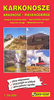
Karkonosze
Karkonosze Mountains in Poland and the Czech Republic on a detailed hiking map at 1:50, 000 from EKO-GRAF, with on the reverse on overview map of hiking trails with timings, seven street plans and a sightseeing map of the region highlighting locations of palaces and other historic buildings in Poland.On one side is a detailed map at 1:50, 000 straddling both sides of the border, from Jelenia Góra in the north to Vrchlabí and Janske Lázne, and from Harrachov to Kamienna Góra. The map has contours at 20m intervals and coloring for forested areas. Numerous hiking trails are coloured according to they waymarking signs and annotated with timings in both directions. Symbols indicate various types of accommodation including campsites and youth hostels. Different types of mountain
transport (cable car or chair lifts, etc) are shown and local roads indicate locations of petrol station. The map has latitude and longitude lines at intervals of 5’. Map legend includes English.On the reverse a large, clear overview map shows the waymarked trails on a plainer background for planning longer connecting routes, also with timings in both directions. Street plans cover central Jelenia Góra and Kamianna Góra, plus the holiday resorts of Szklarska Poreba and Karpacz in Poland, plus Harrachov, Špindleruv Mlýn and Pec pod Snežkou in the Czech Republic. Also provided is a road map of an area between Jelenia Góra and Karpacz in Poland highlighting locations of various palaces and other historic buildings. The accompanying descriptions are in Polish only.
transport (cable car or chair lifts, etc) are shown and local roads indicate locations of petrol station. The map has latitude and longitude lines at intervals of 5’. Map legend includes English.On the reverse a large, clear overview map shows the waymarked trails on a plainer background for planning longer connecting routes, also with timings in both directions. Street plans cover central Jelenia Góra and Kamianna Góra, plus the holiday resorts of Szklarska Poreba and Karpacz in Poland, plus Harrachov, Špindleruv Mlýn and Pec pod Snežkou in the Czech Republic. Also provided is a road map of an area between Jelenia Góra and Karpacz in Poland highlighting locations of various palaces and other historic buildings. The accompanying descriptions are in Polish only.

Product Description
Reviews/Comments
Add New
Intelligent Comparison
Archived Product
Karkonosze Stanfords
£12.99
Archived Product
Krkonose Stanfords
£6.95
Vouchers
No voucher codes found.
Do you know a voucher code for this product or supplier? Add it to Insights for others to use.
Do you know a voucher code for this product or supplier? Add it to Insights for others to use.
 Denmark