More From Contributor
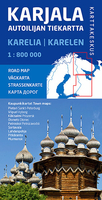
£6.95
Karancs, Medves & the Heves-Borsod Hillsin a series of contoured hiking & recreational maps from the Budapest based Cartographia, with hiking routes & other tourist information, including in many titles street plans, cycling trails, etc. The maps have contours at 10m intervals with relief shading & spot heights, plus colouring and/or graphics to indicate different types of vegetation. An overprint highlights local hiking paths, with cycling routes also included in some titles. Symbols mark various places of interest, sport & recreational facilities, including campsites & other tourist accommodation, locations of petrol stations, etc. The maps show 1km lines of the country ...
Archived Product
£23.99
Map No. 10171, Karasjohka, in the new topographic survey of Norway at 1:50, 000 covering the country on 195 double-sided sheets & first published by Nordeca in 2011
- 2012; fully GPS compatible, indicating waymarked footpaths, campsites, tourist huts, illuminated ski runs, etc. The maps, now published by Nordeca, the successors to Statens Kartverk & its subsequent owners the Ugland Group, are printed on light, waterproof & tear-resistant synthetic paper. Each map covers an area of 62x 45 kilometres (39 x 28 miles approx.), with a 2-km overlap between the sheets. The maps have contours at 20m intervals (10m glacier contours), plus colouring & graphics to show cultivated areas, bogs, forests, etc. In addition to all the information expected of topographic mapping at this scale the maps distinguish between waymarked & unmarked footpaths & show campsites, tourist huts (serviced/self service/no supplies), country hotels & restaurants, & illuminated ski trails. The series uses EUREF89 (WGS84) datum & the maps have a 1-km UTM grid. Map legend is in Norwegian & English. Each title comes in a sturdy protective card envelope.
...
Archived Product
£8.99
Two daringly original works from the acclaimed Danish author Dorthe Nors, published back to back in a uniquely designed edition. ` Beautiful, faceted, haunting stories... Dorthe Nors is fantastic` Junot Diaz Karate Chop In these glittering, funny miniature tales, the acclaimed Danish writer Dorthe Nors sketches ordinary lives taking unexpected turns: a son`s love for his father is tested when he suddenly discovers its fragility; a woman in an abusive relationship seeks to better understand the choices she has made; a man with dreams of self-improvement is haunted by deceit; & a daughter watches on silently as her mother`s search for meaning ends in madness. Blending compassion with dark delight, Nors conjures up a flawed, unsettlingly familiar world with each cautionary glance
- as fresh moments of wonder, romance & frail beauty are unexpectedly infiltrated by depravity, isolation & despair. Minna Needs Rehearsal Space Minna is feeling desperate. Lars has just dumped her by text message. Her friends are constantly flaunting their lovers, children & dogs (with Facebook as their cruel accomplice). & her neurotic sister is everywhere she turns. Minna needs security, & a place in Copenhagen to practise her music. Minna wants a child. Minna needs to stop being answerable to everyone. So, with only Ingmar Bergman for comfort & company, she decides to take a trip away from it all. In this highly original, playful, poignant yet funny novella, Dorthe Nors explores our struggles to find love, relate to others & simply be heard above the relentless noise of the modern age. Praise for Karate Chop ` Unsettling & poetic... Some pieces, like one about a four-pound tomato, are oddly beautiful; others are brilliantly disturbing` New York Times Book Review ` Dorthe Nors is a writer of moments
- quiet, raw portraits of existential meditation, at times dyspeptic, but never unsympathetic` Paris Review ` In the span of two pages, she is able to both build & unmake a character, achieving the same complexity that other writers require entire novels to establish... Karate Chop is the first of Nors` books to be translated to English but certainly won`t be the last. Lovers of the art of literary fiction, students of psychology, & everyone looking for a quick, thought-provoking read should all indulge themselves in the subversive delight of this short story collection` Booklist ` The short-short stories in Danish sensation Nors`s slim, potent collection, Karate Chop...evoke the weirdness & wonder of relating in the digital age` Vogue ` Nors illuminates an ominous world of disconnected people trying to make sense of their dislocation... Nors` affectless, matter-of-fact storytelling...is the perfect complement to the low-wattage desperation & inertia her characters feel... Karate Chop is just like that: It loves you & wants to teach you, but it also wants to harm you` Los Angeles Times ` In this collection of stories, Danish fiction comes off a little like Danish furniture, spare & sublime. Author Dorthe Nors knows how to capture the smallest moments & sculpt them into the unforgettable` Oprah ` Theintricately crafted stories in Karate Chop, from popular Danish writer Dorthe Nors, focus on ordinary occurrences.. .and then twist them into brilliantly slanted cautionary tales about desire, romance, deception, & dread` Elle Praise for Minna Needs Rehearsal Space ` The funniest Danish novel I have read in a long time` Information ` Satirically sharp & satirically funny` Weekendavisen ` This is music to a language lover`s ears` Dagbladenes Bureau, 5-star review ` Tremendously insightful` Jyllands-Posten `A poetic pearl` Berlingske Tidende ` One of the best books I have read` Litteratur Nu ` Short, precise, & hugely entertaining` Litteratursiden

...
Archived Product
£11.99
Karavanke Mountains between the peaks of Kepe & Košutenikov Turn at 1:50, 000 on a waterproof & tear-resistant, contoured & GPS compatible walking & cycling map from Kartografija in Ljubljana, with on the reverse information about local mountain huts. Coverage, including the overprint for hiking trails, cycle routes & other tourist information, spans both sides of the Slovenia / Austria border. On the reverse are map extracts centred on 20 huts specially highlighted on the main map, each with GPS coordinates, seasonal opening dates & contact details, plus a photo. Maps in this series have contours at 20m intervals, enhanced by relief shading, with plenty of spot heights & names of peaks, mountain chains, etc. Local hiking routes are highlighted, indicating difficult passages. Also marked are recommended cycling routes. Symbols indicate various types of accommodation including mountain huts, campsites, inns with lodgings, tourist farms or apartments, hotels & motels, as well as recreational facilities (golf, horse riding, swimming pools, etc), vineries, cultural & historical sites, etc. Road network indicates locations of petrol stations. Railway lines are shown with stations & various types of mountain transport (gondolas, chair lifts, etc) are marked. The maps have a latitude & longitude grid at intervals of 2’’. Map legend & all the text include English. To see the list of titles in this series please click on the series. ...
Archived Product
£13.99
The central area of the Karavanke range at 1:50, 000 in a series of contoured, GPS compatible recreational maps from Planinska zveza Slovenie
- Slovenian Alpine Club, with on the reverse full details of 24 alpine huts including number of beds, seasonal opening months, etc, plus QR codes for further information. Maps at 1:50, 000 in the Planinska zveza series titles have contours at 20m intervals enhanced by shading & graphic relief in the mountainous areas. An overprint highlights local hiking paths, indicating difficult sections. The maps show alpine huts, refuges, hostels, campsites & other types of accommodation, local bus stops, places of interest, etc. Each map covers an area of Approx. 45 x 32km / 28 x 20 miles. Latitude & longitude lines are at 5` intervals, with margin ticks at 1’. On the reverse, most titles also carry detailed information on accommodation for hikers, including opening times of shelters, number of beds, distances to other huts & hostels, GPS coordinates, etc. Some areas are also covered at 1:25, 000. Cartography & hiking information is similar the 1:50, 000 series. Contour interval & geographical coordinates vary. Map legend

Includes::
English. To see the other titles in this series please click on the series grid PLEASE NOTE: map numbers given to the individual titles on our website correspond to our grid & may not necessarily be the same the numbers allocated by the publishers & shown on the different grids on the reverse of the various titles.


...
Archived Product
£13.95
Karelia Road Atlas in a series of detailed atlases of the administrative provinces of the Russian Federation from Roskartografia, with road information shown on a topographic base. Road network

Includes::
minor local roads, service stations, & distances between junctions. Colour coding distinguishes between federal roads & those which are the responsibility of local government. In many areas tracks & footpaths are included. The atlases also show railway lines, as well as inland waterways with locations of locks & the direction of the current. Cities & towns are marked according to the size of their population. Symbols indicate natural landmarks, post offices, hospitals & other facilities, museums, monuments, etc. Topography is shown by contours at 100m intervals & spot heights. Each atlas has an index &

Includes::
an administrative map of the region & a key to Russian road signs. In some atlases coverage is provided only for the areas with roads & not for the whole province. Please see individual descriptions or images of the area coverage supplied with each title. All place names are in the Cyrillic alphabet & the text, including map legends, is in Russian only. In this title: basic street plan of Petrozavodsk 1:100, 000.IMPORTANT
- PLEASE NOTE BEFORE ORDERING: Supplies are very erratic & no delivery date can be guaranteed for titles currently not in stock. Also, we occasionally receive copies with different covers or in different sizes to those indicated on our website. But the cartography & basic information remains as described above.


...
Archived Product
£16.99
Topographic survey of Sweden at 1:100, 000, the Vägkartan, from the Lantmäteriet, covering most of the country in 79 double-sided maps. Please note: the mountainous regions of central & northern Sweden are not covered by this series but presented in a separate “ Fjällkartan
- Mountain Map” series also listed on our website. Each 1:100, 000 topographic survey map covers an area of 75 x 80km. The maps have contours at 10 metre intervals, plus relief shading & colouring for different types of landscape: open l&, forests, alvar, marshes, etc. Boundaries of national parks & nature reserves, areas prohibited to cross-country vehicles, & restricted entry military zones are marked. The maps indicate privately maintained local roads, cycle paths with wind shelters, footpaths, etc, & include all other information expected of topographic survey at this scale. The maps have a 2-km UTM grid, plus latitude & longitude lines 10’ intervals. Map legend

Includes::
English. For coverage of the country’s most visited hiking areas in central & northern Sweden please see Lantmäteriet’s Mountain Map series, listed separately on our website.


...
Archived Product
£9.95
About the series: Maps designed specifically for the trekker, presenting the topography by line drawings of mountain ridges, with main peaks & passes shown with their height above sea level. The maps also show rivers & settlements & clearly indicate trekking routes. On the reverse are descriptions of suggested routes & other information about the area. ...
Archived Product
£17.99
The 1:50 000 topographic map gives a more general picture of the ground features than a basic map. It shows settlements, houses, roads, cultivated areas, waterways, cutting areas, mires, rock exposures, & relief. One map sheet covers an area of 30 x 40 km & one centimetre corresponds to 500 metres on the ground. The 1:50, 000 topographic map is also an ideal complement to nautical charts as it provides useful information about the land areas adjacent to waterways. For example, all Finnish sea areas are covered by 1:50 000 topographic map sheets. ...
Archived Product
£17.99
The 1:50, 000 topographic map gives a more general picture of the ground features than a basic map. It shows settlements, houses, roads, cultivated areas, waterways, cutting areas, mires, rock exposures, & relief. One map sheet covers an area of 30 x 40 km & one centimetre corresponds to 500 metres on the ground. The 1:50, 000 topographic map is also an ideal complement to nautical charts as it provides useful information about the land areas adjacent to waterways. For example, all Finnish sea areas are covered by 1:50, 000 topographic map sheets. ...
Archived Product

Karelia

Double-sided, detailed road map at 1:800, 000 of the Karelian Republic and the Murmansk Oblast with street plans of nine main cities, published by Finland’s national survey organization. Coverage extends from St. Petersburg to Murmansk, and from the adjoining areas of Norway and Finland eastwards to Ostrovno on the Kola Peninsula and on the southern part of the map to beyond Lake Onega. Road network is shown in great detail, including small country roads (incorrectly described in the English translation of the map legend as “private” roads). Locations of petrol stations and car repairs workshops are marked and border crossings indicated. Railway lines and ferry routes are also shown. Protected areas are highlighted and a wide range of symbols indicate accommodation and places to
eat in smaller towns, campsites, winter sport areas, tourist information centres, medical facilities, etc. The map has a latitude grid at intervals of 30’ and longitude at 1º, plus UTM margin ticks. Map legend includes English.Also included are street plans of central St. Petersburg, Murmansk, Petrozavodsk, Vyborg, Priozersk, Sortavala, Olonets, Lahdenpohja and Pitkeranta, highlighting various places of interest and facilities.PLACE NAMES ON THE MAIN MAP: All towns and villages are shown in both Latin and Cyrillic alphabets. In areas which used to be part of Finland, old Finish names are added. Geographical features such as lakes, rivers or bays have only transliterated Russian names, plus in most cases, their Finnish equivalents.PLACE NAMES ON STREET PLANS: Main
streets have Cyrillic and transliterated names, plus, where appropriate, their old Finnish names. Some smaller streets are Cyrillic alphabet only. Names of parks, notable buildings and places of interest are in Cyrillic and transliterated into Finnish only, e.g. Pietari-Paavalin linnoitus for the Peter and Paul Fortress in St. Petersburg.
RIP - This product is no longer available on our network. It was last seen on 25.09.2019

This page now acts as a permanent archive for this product. Add more information using the comments box below to ensure it can still be found by future generations.

Use our search facility to see if it is available from an alternative contributor.
  • External links may include paid for promotion
  • Availability: Out Of Stock
  • Supplier: Stanfords
  • SKU: 9789522663597
Availability: In Stock
£17.50

Product Description

Double-sided, detailed road map at 1:800, 000 of the Karelian Republic & the Murmansk Oblast with street plans of nine main cities, published by Finland’s national survey organization. Coverage extends from St. Petersburg to Murmansk, & from the adjoining areas of Norway & Finland eastwards to Ostrovno on the Kola Peninsula & on the southern part of the map to beyond Lake Onega. Road network is shown in great detail, including small country roads (incorrectly described in the English translation of the map legend as “private” roads). Locations of petrol stations & car repairs workshops are marked & border crossings indicated. Railway lines & ferry routes are also shown. Protected areas are highlighted & a wide range of symbols indicate accommodation & places to eat in smaller towns, campsites, winter sport areas, tourist information centres, medical facilities, etc. The map has a latitude grid at intervals of 30’ & longitude at 1º, plus UTM margin ticks. Map legend

Includes::
English. Also included are street plans of central St. Petersburg, Murmansk, Petrozavodsk, Vyborg, Priozersk, Sortavala, Olonets, Lahdenpohja & Pitkeranta, highlighting various places of interest & facilities.PLACE NAMES ON THE MAIN MAP: All towns & villages are shown in both Latin & Cyrillic alphabets. In areas which used to be part of Finl&, old Finish names are added. Geographical features such as lakes, rivers or bays have only transliterated Russian names, plus in most cases, their Finnish equivalents.PLACE NAMES ON STREET PLANS: Main streets have Cyrillic & transliterated names, plus, where appropriate, their old Finnish names. Some smaller streets are Cyrillic alphabet only. Names of parks, notable buildings & places of interest are in Cyrillic & transliterated into Finnish only, e.g. Pietari-Paavalin linnoitus for the Peter & Paul Fortress in St. Petersburg.

Reviews/Comments

Add New

Intelligent Comparison

Oooops!
We couldn't find anything!
Perhaps this product's unique.... Or perhaps we are still looking for comparisons!
Click to bump this page and we'll hurry up.

Price History

Vouchers

No voucher codes found.
Do you know a voucher code for this product or supplier? Add it to Insights for others to use.

Facebook

Jargon Buster

Car - A machine used for transport which runs on roads
Network - A link and communication between things. Often computers or people.
Small - something that takes up less space than normal.
Road - a manmade lane or a path that is used to speed up travel.
Wide - Something with a large width.
Accommodation - A room in which someone can live in, for example in a hotel
Winter - The fourth season of a year that comes between Spring and Autumn

Supplier Information

Stanfords
Stanfords was established in 1853 and opened their iconic Covent Garden flagship store in 1901. They have become the top retailer of maps, travel books and accessories in the UK and arguably offer the largest selection of maps and travel books worldwide. Famous names such as Captain Robert Falcon Scott, Ranulph Fiennes and Michael Palin have purchased from Stanfords. They now have a shop in Bristol and both stores together with other venues operate a calendar of events including talks, book signings and exhibitions. As a specialist map retailer, the map selection is comprehensive and includes road maps, street maps and walking maps from worldwide destinations, as well as a selection of world atlases and wall maps. Books include travel guides and travel literature. Stanfords also stock globes, from miniatures made of blue marble to magnificent floor-standing globes. The website features a selection of interesting articles on travel topics.
Page Updated: 2023-11-12 20:15:36

Community Generated Product Tags

Oh No! The productWIKI community hasn't generated any tags for this product yet!
Menu