More From Contributor

£10.39
Map No. 61, Jura & Colonsay, in waterproof & tear-resistant version of the Ordnance Survey Landranger series at 1:50, 000, including on Jura Inverlussa, Tarbert, Lagg, Knockrome, Cabrach, Craighouse, Feolin Ferry, plus the Pass of Jura & the peaks of Cruach na Seilcheig, Beinn Bhreac & Beinn an Oir; on Colonsay Scalasaig & Rubh' a' Geodha; on Islay Bunnahabhain, Port Askaig/ Port Asgaig, Ballygrant & Bridgend; plus Keillbeg, Kilmory, Kilbery Head, Rubh' a' Mhail & the Sound of Jura. Edition B2; Revised for selected changes 2007; Copyright date 2007 This title is also available on our website in a paper version. Maps in this series are only published folded. Stanfords can also print flat versions of Ordnance Survey maps through the OS Select system, centring the map on a location of your choice & with a picture provided by you on the cover. For more information please click on the link at the bottom of this description. About Ordnance Survey ...
Archived Product
£20.99
Le Jura à pied, FFRP topo-guide Ref. No. D039, with 46 day walks of varying length & difficulty in the department of Jura in the southern part of the Jura Mountains. Each walk is presented on a separate colour extract from IGN’s topographic survey of France at 1:25, 000, with its description cross-referenced to the map. Current edition of this title was published in June 2015. To see the list of other FFRP guides with day walks please click on the series link.ABOUT THE FFRP (Fédération française de la randonnée pédestre) TOPOGUIDES: published in a handy A5 paperback format, the guides are the best companions for hiking in France. In addition to their topo-guides to the long-distance GR routes FFRP also publish an extensive range of guides with local day walks. Each walk in presented on a colour extract from IGN`s 1:50, 000 or 1:25, 000 topographic survey mapping overprinted with the route, with important points cross-referenced to the accompanying text, in French only, placed on the adjoining page. For each walk the guides also indicate the degree of difficulty & provide information on length, time & change in altitude, waymarking signs, access by road & parking facilities. An “info practiques” section of the guide indicates where shops, restaurants & accommodation can be found. The guides are published on high quality paper & include descriptions of the most interesting aspects of the surrounding region: historical & cultural sites, local specialties, fauna & flora, etc, all illustrated with colour photos. ...
Archived Product
£10.36
Walking on Jura, Islay & Colonsay, a Cicerone guide by Peter Edwards, contains 12 challenging walks on the Southern Hebrides islands, with routes through tough & often trackless terrain described with clarity & accompanied by Ordnance Survey map segments. Included is a five day Jura west coast walk, as well as detailed information on cultural & natural history is provided. Walks lead you through some of the finest wilderness walking in Great Britain
- along the coast of Jura with its dramatic geology, empty beaches & abundant wildlife, around Islay with its birdlife, historical sites & distilleries, & on Colonsay with its tranquillity.
...
Archived Product
£14.95
Walking on Jura, Islay & Colonsay, a Cicerone guide by Peter Edwards, contains 15 challenging walks on the Southern Hebrides islands, with routes through tough & often trackless terrain (suitable only for fit, competent & well-equipped walkers), described with clarity & accompanied by Ordnance Survey map segments. Walks lead you through some of the finest wilderness walking in Great Britain
- along the coast of Jura, with its dramatic geology, empty beaches & abundant wildlife, around Islay with its birdlife, historical sites & distilleries, & on Colonsay with its tranquillity. This guide

Includes::
the five-day Jura west coast walk, detailed information on cultural & natural history as well as inspiring photographs.


...
Archived Product
£19.99
Jura: Delémont – Biel/ Bienne area at 1:60, 000 in Kümmerly + Frey’s series of cycling maps published in co-operation with the Association for Transport & Environment & showing the official “ Cycling in Switzerland” routes. The aim of the series is to present a network of routes with as few problems as possible caused by motor traffic. The maps have a detailed base, with contours plus graphic relief & shading providing an excellent representation of the terrain. Routes are classified according to the density of motorized traffic, the difficulty of the terrain, & road restrictions. Unsurfaced roads are indicated, gradient marks show steep inclines, & local danger spots are highlighted. The maps show facilities for transporting cycles by train, bus, ferries, mountain railways, chair lifts, & cable cars. Border crossings indicate those open only to hikers & cyclist during daylight hours. Bike rental facilities are marked & towns with special bicycle-friendly accommodation are highlighted. Other tourist information

Includes::
various types of accommodations (campsites, youth hostels, “ Friends of Nature” houses, etc), viewpoints, picnic sites, swimming pools, & places of interest. Each title covers an area of Approx. 60 x 42 km (37 x 26 miles). The maps have a 1km grid for GPS users, with latitude & longitude shown as margin ticks. Map legend

Includes::
English. On the reverse, an index of towns & villages also lists names of geographical features such as mountains, alpine passes, glaciers, etc. Also included is general information on the country’s long-distance cycling routes & on transporting bikes by train (text

Includes::
English). To see the list of titles in this series please click on the series link.


...
Archived Product
£12.95
The Jurassic Coast of Devon & Dorset, stretching between Exeter & Bournemouth, is a geological wonderl&. Natural wonders like Chesil Beach, Durdle Door & fossils so numerous you`ll be tripping over them, combine with southern England`s rolling Downs, tiny villages, beaches & sunny summers to provide a stunning & awe-inspiring landscape to explore. The 30 walks in this guide let walkers discover the best & most spectacular areas on the coast. The walks are between 5 & 25km (3 to 16 miles) & provide a range suitable for all abilities. The guide has been divided into areas: Devon`s Red Beds, the Lias, Chesil Beach, Chalk walks (Lulworth & inland) & the Isle of Purbeck. The geological descriptions are accompanied by strata diagrams, geological timelines, explanations of the creation of the various sedimentary rocks along the coast, & discussion of how & why the various formations formed millennia ago. The incredible
- yet readable
- detail brings these walks & the landscape alive. & yet, the routes can just as easily be walked for their own sake & the pleasure of rolling downs, high cliffs & beach sunshine. As well as detailed descriptions for every walk, accompanied by OS maps, there are details on available parking, points of interest along the way (on rocks & other sights) & advice on the terrain covered. The general & geological introductions provide background on the region & the appendices give thorough information on local museums & information centres, cliff diagrams, a glossary of geological terms & a quick, look-up guide to the rocks of the Jurassic Coast. More than just a walking guidebook, this book is an invitation to explore & learn about this spectacular Natural World Heritage area.

...
Archived Product
£9.50
Topographical survey of Belgium at 1:20, 000 from Nationaal Geografisch Instituut / Institut Géographique National, the country’s national survey organization. Each 20K map covers one quarter of the corresponding 1:50, 000 map (with adjustments in the border & coastal areas). The maps provide all the information expected of topographic mapping at this scale & in addition have an unusually large amount of vegetation and/or land use information (different types of woodlands, gardens, orchards, heath, etc). The maps have a 1-km UTM grid, with margin ticks for latitude & longitude at intervals of 1`. Map legend & a glossary of terms used on the maps include English. Stanfords keeps as regular stock 20K maps for the World War I battlefields around the Ypres, Messines & Passchendaele, & for the area of the Battle of Waterloo. The 1:20, 000 survey covers the whole of Belgium & maps for other regions can be supplied as special orders. To see the list of titles in this series please click on the series link.PLEASE NOTE: the Long-Distance Footpaths Map of Belgium at 1:300, 000 which shows the division of Belgium into the 50K survey sheets can also be used to see in more detail coverage by the 20K maps. ...
Archived Product
£17.99
The 1:50 000 topographic map gives a more general picture of the ground features than a basic map. It shows settlements, houses, roads, cultivated areas, waterways, cutting areas, mires, rock exposures, & relief. One map sheet covers an area of 30 x 40 km & one centimetre corresponds to 500 metres on the ground. The 1:50, 000 topographic map is also an ideal complement to nautical charts as it provides useful information about the land areas adjacent to waterways. For example, all Finnish sea areas are covered by 1:50 000 topographic map sheets. ...
Archived Product
£17.99
Topographic survey of Portugal at 1:50, 000 from the Instituto Geográfico do Exército, the country’s military survey organisation. The maps have contours at 20m intervals & in addition to the standard features shown on topographic mapping at this scale also indicate various types of terrain or vegetation (s&, terraces, rocks, woodlands, vineyards, etc). Each sheet covers an area of 32 x 20km (20 x 12.5 miles approx). The maps have a 1-km UTM grid plus latitude & longitude coordinates for the map corners. Map legend & a glossary of terms used on the maps include English.EDITION DATES: most titles in this series date from 1990s or later. To see all the titles in this series please click on the series link. ...
Archived Product
£17.99
Topographic survey of Portugal at 1:50, 000 from the Instituto Geográfico Português, the country’s civilian survey organisation. The maps have contours at 25m intervals & in addition to the standard features shown on topographic mapping at this scale also indicate various types of vegetation (vineyards, olive groves, etc). Each sheet covers an area of 32 x 20km (20 x 12.5miles approx). The maps have latitude & longitude margin ticks at 1’ intervals & UTM coordinates for the map corners – each sheet also shows conversion details from BBLx (Bessel-Bonnie system, Datum Lisbon) to UTM. Map legend is in Portuguese only.EDITION DATES: most titles in this series have now been updated in the 1990s or later. To see all the titles in this series please click on the series link. ...
Archived Product

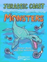
Jurassic Coast Monsters

For children aged 4-12 the book is an introduction to the `Jurassic Coast`. Packed with fascinating facts about fossils and Jurassic Coast creatures, fun activities, and child friendly explanations of how fossils are formed and why the Jurassic Coast is such a scientifically important and special place. Stickers help children to explore the three different environments that make up the fossil record along the coast, through these pages they can discover the different creatures that roamed the area all those millions of years ago. There is also information on where fossils are found along the coast and where best to look for them including SAFE fossil collection based on the fossil collectors code.
RIP - This product is no longer available on our network. It was last seen on 25.09.2019

This page now acts as a permanent archive for this product. Add more information using the comments box below to ensure it can still be found by future generations.

Use our search facility to see if it is available from an alternative contributor.
  • External links may include paid for promotion
  • Availability: Out Of Stock
  • Supplier: Stanfords
  • SKU: 9780954484590
Availability: In Stock
£2.99

Product Description

For children aged 4-12 the book is an introduction to the ` Jurassic Coast`. Packed with fascinating facts about fossils & Jurassic Coast creatures, fun activities, & child friendly explanations of how fossils are formed & why the Jurassic Coast is such a scientifically important & special place. Stickers help children to explore the three different environments that make up the fossil record along the coast, through these pages they can discover the different creatures that roamed the area all those millions of years ago. There is also information on where fossils are found along the coast & where best to look for them including SAFE fossil collection based on the fossil collectors code.

Reviews/Comments

Add New

Intelligent Comparison

Oooops!
We couldn't find anything!
Perhaps this product's unique.... Or perhaps we are still looking for comparisons!
Click to bump this page and we'll hurry up.

Price History

Vouchers

No voucher codes found.
Do you know a voucher code for this product or supplier? Add it to Insights for others to use.

Facebook

Jargon Buster

Fun - Something that provides amusement or enterainment
Children - A young life form within the early stages of physical development,

Supplier Information

Stanfords
Stanfords was established in 1853 and opened their iconic Covent Garden flagship store in 1901. They have become the top retailer of maps, travel books and accessories in the UK and arguably offer the largest selection of maps and travel books worldwide. Famous names such as Captain Robert Falcon Scott, Ranulph Fiennes and Michael Palin have purchased from Stanfords. They now have a shop in Bristol and both stores together with other venues operate a calendar of events including talks, book signings and exhibitions. As a specialist map retailer, the map selection is comprehensive and includes road maps, street maps and walking maps from worldwide destinations, as well as a selection of world atlases and wall maps. Books include travel guides and travel literature. Stanfords also stock globes, from miniatures made of blue marble to magnificent floor-standing globes. The website features a selection of interesting articles on travel topics.
Page Updated: 2023-11-12 20:15:36

Community Generated Product Tags

Oh No! The productWIKI community hasn't generated any tags for this product yet!
Menu