
 United Kingdom
 France
 Germany
 Netherlands
 Sweden
 USA
USA
 Italy
Italy
 Spain
Spain
More From Contributor


Jordan Reise Know-How
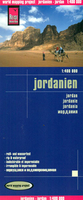
Jordan at 1:400, 000 on an indexed, waterproof and tear-resistant road map with topographic and tourist information, published by Reise Know-How as part of their highly acclaimed World Mapping Project. The map is double-sided, with a generous overlap between the sides, to provide the best balance between a good scale and a convenient size sheet. Coverage extends northwards to Damascus and part of the West Bank is included with Jerusalem and Ramallah. All place names are in the Latin alphabet; names of larger towns are also shown in Arabic.The country’s topography is presented by altitude colouring with spot heights, names of mountain ranges and passes, salt pans, seasonal rivers and lakes, etc. Road network includes unsurfaced local roads and tracks, indicating driving distances
on main and secondary roads and border crossings. Railways lines are included and local airfields are marked. Symbols highlight various places of interest, including UNESCO World Heritage sites, mosques and churches, selected hotels, national parks and nature reserves, hot springs, viewpoints, etc. The map also shows internal administrative boundaries with names of the provinces. Latitude and longitude lines are drawn at15’ intervals. Extensive index of localities has a separate list of places of interest. Map legend includes English.
on main and secondary roads and border crossings. Railways lines are included and local airfields are marked. Symbols highlight various places of interest, including UNESCO World Heritage sites, mosques and churches, selected hotels, national parks and nature reserves, hot springs, viewpoints, etc. The map also shows internal administrative boundaries with names of the provinces. Latitude and longitude lines are drawn at15’ intervals. Extensive index of localities has a separate list of places of interest. Map legend includes English.

Product Description
Reviews/Comments
Add New
Vouchers
No voucher codes found.
Do you know a voucher code for this product or supplier? Add it to Insights for others to use.
Do you know a voucher code for this product or supplier? Add it to Insights for others to use.
 Denmark